Beeley Wood

Last updated

Beeley Wood
Beeley Wood from the SW.jpg
Beeley Wood seen from the south-west across the upper Don valley
South Yorkshire UK location map.svg
Red pog.svg
Beeley Wood
Type woodland
Location City of Sheffield, South Yorkshire, England
Coordinates 53°25′47″N1°31′32″W / 53.42972°N 1.52556°W / 53.42972; -1.52556 Coordinates: 53°25′47″N1°31′32″W / 53.42972°N 1.52556°W / 53.42972; -1.52556

Beeley Wood is a woodland in the north of the City of Sheffield, near Middlewood, South Yorkshire, England. It is one of 35 ancient woodland areas within the Sheffield city boundary. An ancient woodland is defined as a site that has been continuously occupied by woodland from the year 1600 or before.

Contents

Overview

The woods are situated on the eastern side of the River Don between the village of Oughtibridge and the Sheffield suburb of Middlewood. The most common access from the Middlewood end of the wood is from the end of Clay Wheels Lane or from Middlewood Road South over the Don by the Rocher footbridge. The woods cover an area of approximately 150 acres (60 ha) and slope up quite steeply from the river gaining around 230 feet (70 m) in height before ending at farmland. The wood is traversed by two public footpaths;the lower of these is a pleasant and recently re-covered riverside walk which is part of the Upper Don Walk, a scenic walk by the river from the centre of Sheffield to Oughtibridge. [1] The other public footpath runs the length of the upper wood at its highest point; there are many other paths not marked on the OS map. Beeley Wood is traversed by the famous Woodhead railway line; there is one level crossing and one footbridge for pedestrians to cross the line. The woods are home to a large colony of bats and all three species of woodpecker native to Britain can be seen in the woods. In spring there is a large covering of bluebells on the woodland floor. Wilson Spring Wood, a small area of wood, classed as an ancient and semi natural woodland, measuring approximately 980 by 820 feet (300 by 250 m) lies to the north-east of the main wood, separated by an area of farmers' fields 980 feet (300 m) in width.

History

The earliest written reference to Beeley Wood is in a deed dated from 1161 in which the monks of Ecclesfield Priory were given permission to graze their flock every year from January to Easter in a large wood stretching from Birley Edge down to the River Don. Beeley Wood is a surviving part of this large wood and part of it is still called Priory Wood. In this 12th century document the wood was referred to as "BYLLHAUWODE" which is derived from the two Old English words Billa and haga and means Billa's enclosure and suggests that the woodland was originally attached to an Anglo-Saxon farm belonging to Billa. [2] Further mention was made in a document released upon the death of Thomas de Furnival in 1332 when Beeley Wood was named as one of eleven locations under the heading of Woods, Moors and Commons. Under this agreement people were allowed to graze their animals in the wood. However, by the 16th century Beeley Wood had become a coppice wood in which the pasturing of animals was discouraged. At the end of the 16th century Beeley Wood was one of eleven coppice woods in Sheffield which were mentioned in a document drawn up for Gilbert Talbot, 7th Earl of Shrewsbury.

The River Don flowing through Beeley Wood. River Don in Beeley Wood.jpg
The River Don flowing through Beeley Wood.

By the 1890s the coppicing of Beeley Wood along with the other coppice woods in Sheffield was coming to an end because of reduced profits and woodland management problems. The wood was allowed to become a "high forest" with the strongest growth of a coppiced tree allowed to grow into a fully grown standard tree. Many of the older and sickly trees were cleared away at this time and replaced by saplings of trees that were not native to the Sheffield area, such as beech, sweet chestnut, common lime and sycamore. In late 1898 the Duke of Norfolk's forester planted Beeley Wood with 60 acres (24 ha) of timber trees such as ash, elm, sycamore, birch, lime, sweet chestnut and beech. The young trees were ordered from a nursery in Cheshire and were delivered to Wadsley Bridge railway station. [3] In 2011 the Forestry Commission approved funding for a five-year plan to improve the unmanaged habitat of the wood; under the scheme an area of 9.6 acres (3.9 ha) will be coppiced and a further 2.7 acres (1.1 ha) will be thinned to allow more light and warmth into the wood and therefore improve conditions for wild flowers, insects and birds. [4] In February 2016 the Environment Agency removed the middle two-thirds of Beeley Wood Lower Weir on the River Don as part of a scheme to allow the free migration of fish and let the river return to a more natural form. [5]

Mining and quarrying

Although not apparent today, Beeley Wood was once an area of industry with mining and quarrying taking place. Ganister was the material that was mined; this is a type of hard sandstone used in the manufacture of silica bricks used to line industrial furnaces. The Drift mining method was used because of the slope of the land in Beeley Wood and the mines went into the hillside for a long way and to a great depth. The fact that the wood is on a slope enabled gravity trackways to be used to transport the Ganister down to the valley bottom. The Ganister was also quarried in at least one location in the woods and the overgrown remnants of a large quarry can still be seen today. The largest of the mines was the Beeley Wood Mine, owned by the Silica Fire Brick Company and managed by J.T. Minnis for many years, in the 1920s and 1930s over 30 workers were employed and 12 ponies were used. [6] [7] In recent years the Coal Authority have inspected and fenced off various old shafts in the upper part of the wood.

Other industry

There is other industry on the eastern (Middlewood) fringes of the wood with the Beeley Wood Works situated at the end of Clay Wheels Lane, this is currently occupied by the Abbey Stainless Steel Company but has a long history dating back to 1749 when it was known as the Nova Scotia Tilt Company. [8] For many years there was a large Union Carbide factory (formerly owned by British Acheson Electrodes Ltd., formerly Electrode Company of Sheffield Ltd., ) in this area manufacturing carbon electrodes for the steel industry, graphite rods for the nuclear industry and related products but this closed several years ago with the site lying disused for some time. In 1976 the plant employed 850 people with a subsidiary works in Wincobank, Sheffield, employing a further 150 people. The 45-acre (18 ha) site received planning permission in January 2009 to be used as a "Recycling Village" run by the firm Ballast Phoenix Ltd. who will initially recycle the ash from Sheffield's main Energy from Waste incinerator. [9] [10]

Related Research Articles

River Don, Yorkshire River in South Yorkshire and the East Riding of Yorkshire, England

The River Don is a river in South Yorkshire and the East Riding of Yorkshire, England. It rises in the Pennines, west of Dunford Bridge, and flows for 70 miles (110 km) eastwards, through the Don Valley, via Penistone, Sheffield, Rotherham, Mexborough, Conisbrough, Doncaster and Stainforth. It originally joined the Trent, but was re-engineered by Cornelius Vermuyden as the Dutch River in the 1620s, and now joins the River Ouse at Goole. Don Valley is a UK parliamentary constituency near the Doncaster stretch of the river.

Beauchief Abbey Medieval monastic house now serving as a parish church in the southern suburbs of Sheffield, England

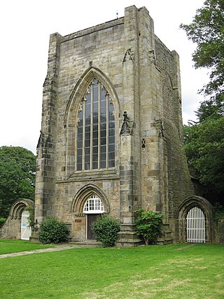
Beauchief Abbey is a medieval monastic house now serving as a parish church in the southern suburbs of Sheffield, England. Beauchief is pronounced bee-chiff.

The Moss

The Moss is a brook in North East Derbyshire, England.

Worrall Village in South Yorkshire, England

Worrall is a small rural village in the civil parish of Bradfield within the boundary of the City of Sheffield in South Yorkshire, England. It stands in an elevated position at a height of approximately 230 metres and is 4 miles (6.5 km) north west of Sheffield City Centre. The village has an area of 233 hectares and a population of 1,306 in 2006. At the time of the 2011 Census this village fell within the Stannington ward of the City. Gives details of population and area of village. Although a distinct village, Worrall has tenuous borders with the Sheffield suburbs of Wadsley, Middlewood and Loxley to the south and east and with the adjoining village of Oughtibridge to the north; to the west is a rural area extending out towards the village of High Bradfield.

Whirlow Suburb of Sheffield, South Yorkshire, England

Whirlow is a suburb of the City of Sheffield in England, it lies 3.7 miles (6 km) south-west of the city centre. The suburb falls within the Dore and Totley ward of the City. It is one of the most affluent areas of Sheffield, with much high class housing and several notable small country houses within it. During the Victorian era it was home to some of Sheffield's most influential citizens. Whirlow straddles the A625, the main Sheffield to Hathersage road. The suburb covers the area from Parkhead in the north to Whirlow Bridge in the south and from Ecclesall Woods in the east to Broad Elms Lane in the west. Whirlow had a population of 1,663 in 2011.

Wadsley Human settlement in England

Wadsley is a suburb of the City of Sheffield in South Yorkshire, England. It stands 3 miles (5 km) north-west of the city centre at an approximate grid reference of SK321905. At the 2011 Census the suburb fell within the Hillsborough ward of the City. Wadsley was formerly a rural village which was engulfed by the expansion of Sheffield in the early part of the 20th century.

Oughtibridge Village in South Yorkshire, England

Oughtibridge is a residential village on the northern outskirts of Sheffield within the bounds of Bradfield civil parish. The village stands 5 miles (8 km) northwest of the city centre in the valley of the River Don. The population of the village has increased significantly in recent years due to much private housing development and stood at 3,542 in 2006 over an area of 355 hectares. The population of Oughtibridge increased to 3,584 in 2011.

Sheffield is the most geographically diverse city in England. Lying in the eastern foothills of the Pennines, the city nestles in a natural amphitheatre created by several hills and the confluence of five rivers: Don, Sheaf, Rivelin, Loxley and Porter. As such, much of the city is built on hillsides, with views into the city centre or out to the countryside. The city is roughly one third urban, one third rural and one third in the Peak District. At its lowest point the city stands just 29 metres above sea level at Blackburn Meadows on the Rotherham border, rising up to over 500 m in some parts of the city to a peak of 548m at High Stones on the Derbyshire border; however, 89% of the housing in the city is between 100 and 200 metres above sea level. Over 95% of the population resides in the main urban area.

Langsett Reservoir Reservoir in South Yorkshire, England

Langsett Reservoir is in Yorkshire, England, near the villages of Langsett and Upper Midhope, on the edge of the Peak District National Park. The reservoir was constructed between 1898 and 1904, and is now managed by Yorkshire Water. Fed by the Little Don or Porter River, it is around a mile long, and supplies water for Sheffield and Barnsley via the Langsett Treatment Works.

Middlewood, South Yorkshire Suburb of Sheffield, South Yorkshire, England

Middlewood is a north western suburb of Sheffield, South Yorkshire, England. The suburb falls within the Stannington ward of the City.

Hutcliffe Wood

Hutcliffe Wood and Marriott Wood are two areas of ancient woodland in Sheffield, South Yorkshire, England. They occupy the steep southeastern side of the Abbeydale valley between Archer Road and Abbey Lane, separated by the River Sheaf and the railway line from Millhouses Park. Hutcliffe Wood Road divides the two areas of woodland, Hutcliffe Wood to the west and Marriott Wood to the east.

Wharncliffe Crags

Wharncliffe Crags is a gritstone escarpment or edge situated approximately 10 km (6 mi) north west of the city of Sheffield in South Yorkshire, England. It is a geological Site of Special Scientific Interest.

Neepsend Suburb of Sheffield in South Yorkshire, England

Neepsend is a suburb of the city of Sheffield, it stands just 1 mile (1.6 km) north-west of the city centre. The main area of Neepsend covers the flood plain of the River Don from Lady's Bridge at the Wicker up to Hillfoot Bridge. The suburb falls within the Central Ward of the City. The adjacent district of Parkwood Springs is often regarded as part of the suburb.

Bedford Purlieus National Nature Reserve 211-hectare (520-acre) [[ancient woodland]] in Cambridgeshire, in the United Kingdom

Bedford Purlieus is a 211-hectare (520-acre) ancient woodland in Cambridgeshire, in the United Kingdom. It is a national nature reserve and Site of Special Scientific Interest owned and managed by the Forestry Commission. In Thornhaugh civil parish, 10 km (6.2 mi) south of Stamford and 14 km (8.7 mi) west of Peterborough, the wood is within the Peterborough unitary authority area of Cambridgeshire, and borders Northamptonshire. In Roman times it was an iron smelting centre, during the medieval period it was in the Royal Forest of Rockingham, and later it became part of the estates of the Duke of Bedford. Bedford Purlieus appears to have been continuously wooded at least from Roman times, and probably since the ice receded. The woodland may have the richest range of vascular plants of any English lowland wood. It acquired particular significance in the 1970s as an early subject for the historical approach to ecology and woodland management.

Lower Wye Gorge SSSI

Lower Wye Gorge is a 65-hectare (160-acre) biological and geological Site of Special Scientific Interest in Gloucestershire, notified in 1954 and renotified 1987. The site includes two Gloucestershire Wildlife Trust nature reserves being Ban-y-gor Wood and Lancaut. The Natural England citation states a revision for Lancaut inclusion.

Gleadless Valley Human settlement in England

Gleadless Valley is a housing estate and electoral ward of the City of Sheffield in England. The population of the ward at the 2011 Census was 21,089. It lies 2.5 miles (4.0 km) south-southeast of the city centre. Formerly a rural area, Gleadless Valley was developed as a large housing project with around 4000 dwellings by Sheffield City Council between 1955 and 1962. It is an area of undulating land drained by the Meers Brook, which has its source on the high ground in the woodland at Gleadless. Adjacent are Gleadless to the east, Norton to the south-west, Heeley to the west and Arbourthorne to the north.

Three Groves Wood Nature reserve in Gloucestershire, England

Three Groves Wood is a 3.3-hectare (8.2-acre) nature reserve in Gloucestershire. The site is listed in the ‘Stroud District’ Local Plan, adopted November 2005, Appendix 6 as a Key Wildlife Site (KWS).

Glen Howe Park

Glen Howe Park is a public recreation area in the village of Wharncliffe Side within the City of Sheffield, England. The park covers an area of 19 acres in the valley of the Tinker Brook, a minor tributary of the River Don. It is home to a variety of fungi, rare plants and animals only found in ancient woodlands.

Ughill Hamlet in South Yorkshire, England

Ughill is a small, rural hamlet within the City of Sheffield in Bradfield Parish in England. It is 5 mi west-northwest of the city centre. It stands in a lofty position at 918 ft above sea level, on a ridge between Bradfield Dale and the valley of the Ughill Brook. It has traditionally been a farming community, but there was some mining in the area in the late 19th and 20th century. Ughill Hall was the scene of an infamous murder in September 1986. The hamlet falls within the Stannington ward of the City.
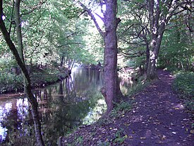
Upper Don Walk

The Upper Don Walk is a six mile long recreational walk which links the centre of Sheffield to the village of Oughtibridge to the north west of the city. It follows the course of the River Don and partially the National Cycle Network route 627. The route is variable in quality, the first mile is well defined as it has been integrated into the newly developed quarters to the immediate north of the city centre. The rest of the route is a mixture of path, road and woodland walking.

References

  1. www.waterscape.com. Gives some details of Upper Don Walk.
  2. Woodland Heritage Manual 2008. Archived 9 July 2015 at the Wayback Machine Gives etymology and history.
  3. "Sheffield‘s Woodland Heritage", Mel Jones, ISBN   0-9521733-0-1 Gives historical details.
  4. information board at site. Gives details of modern day coppicing and thinning.
  5. Environment Agency Partial removal of Beeley Wood Lower Weir.
  6. "The Forgotten Mines of Sheffield", Ray Battye, ISBN   1-901587-40-1 Gives details of Ganister mining in Beeley Wood.
  7. List of Mines in Great Britain and the Isle of Man, 1908. Gives some details of Beeley Wood Mine.
  8. www.ehs.org.uk. Archived 16 July 2011 at the Wayback Machine Gives dates for Nova Scotia Tilt.
  9. Sheffield Telegraph. Gives details of "Recycling Village" at eastern end of Beeley Wood.
  10. Veolia Environmental Services. Archived 4 February 2009 at the Wayback Machine Gives details of Sheffield's Energy from Waste scheme.