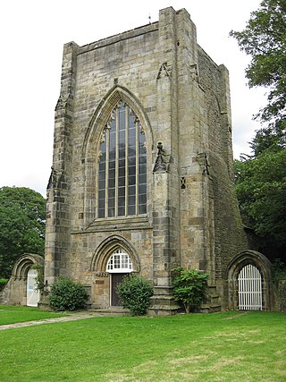
Beauchief Abbey is a medieval monastic house now serving as a parish church in the southern suburbs of Sheffield, England.

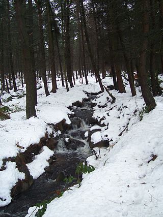
The Moss is a brook in North East Derbyshire, England.
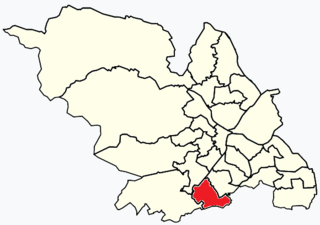
Beauchief and Greenhill ward—which includes the districts of Batemoor, Beauchief, Chancet Wood, Greenhill, Jordanthorpe, Lowedges and Meadowhead—is one of the 28 electoral wards in the City of Sheffield, England. It is in the southern part of the city and covers an area of 2.4 square miles (6.2 km2). The population of the ward in 2016 was estimated to be 19,669 people in 9,209 houses.
Swithland Wood and The Brand is a 87.9 hectares biological Site of Special Scientific Interest south of Woodhouse Eaves in Leicestershire. Swithland Wood is a Nature Conservation Review site, Grade II. The Brand is designated a Precambrian site in the Geological Conservation Review, but the dating has been changed due to the discovery of trace fossils from the succeeding Cambrian period.

The Cholera Monument is a memorial in Sheffield, England, to the victims of a cholera epidemic of 1832. Of the 402 disease victims, 339 were buried in grounds between Park Hill and Norfolk Park adjoining Clay Wood. Money from the treasurers of the Board of Health was set aside for a monument for the site.

Endcliffe Park is a large park in the city of Sheffield, South Yorkshire, England. The park was opened in 1887 to commemorate the Jubilee of Queen Victoria. When travelling West from the city centre it is the first in a series of parks and green spaces, known collectively as the Porter Valley Parks, all of which lie along the course of the Porter Brook. The next park in the sequence is Bingham Park, separated from Endcliffe Park by Rustlings Road. In 1924 Patrick Abercrombie said of the parks, "The Porter Brook Parkway, consisting as it does of a string of contiguous open spaces, is the finest example to be found in this country of a radial park strip, an elongated open space, leading from a built-up part of the city direct into the country, the land occupied being a river valley and so for the greater part unsuitable for building."
Ecclesall Woods is an area of woodland in south-west Sheffield, South Yorkshire, England, between Abbeydale Road South and Ecclesall. It covers approximately 350 acres (1.4 km2) of mature semi-natural deciduous woodland which was previously used for timber and charcoal, and is currently managed by the city council for the benefit of wildlife and visitor access. There are two roads and over 10 miles (16 km) of public footpaths running through the woods. The Abbeydale miniature railway is also located within the woods.
The Limb Brook is a stream in Sheffield, South Yorkshire, England. It rises at the village of Ringinglow, flowing east through Whirlow and Ecclesall Woods into Abbeydale in the Beauchief area, where it merges with the River Sheaf. Near this point part of the stream has been diverted to provide the goit for the Abbeydale Industrial Hamlet millpond, and this channel flows through what is now Beauchief Gardens.
The Heaton Woods Trust is both the name for the charity and the woodland it cares for located mainly in Heaton, Bradford, West Yorkshire, England but also stretches into Shipley. The Heaton Woods Trust is a registered charity that was established in 1977. The Heaton Woods Trust is responsible for the care and protection of the woods for the benefit of present and future generations.

Shire Brook is a small stream in the south eastern part of the City of Sheffield in South Yorkshire, England. It rises in the suburb of Gleadless Townend and flows in a general easterly direction for 4 miles (6.5 km) to its confluence with the River Rother between Beighton and Woodhouse Mill. In the past the brook has been both the border of Yorkshire and Derbyshire and between the sees of Canterbury and York. The course of the stream has been influenced by human intervention in the 20th century with the brook being diverted underground and flowing through culverts on three occasions as it traverses locations which were formerly landfill sites and extensive railway sidings.

Strines Reservoir is a water storage reservoir situated at 53.4099°N 1.6557°W, 8 miles (13 km) west of the centre of Sheffield in South Yorkshire, England.

The Ponderosa is a recreation area within the City of Sheffield, South Yorkshire, England. Although not a public park it was designated as Open Space by Sheffield City Council in the 1993 Unitary Development Plan. It covers an area of over 25 acres (10 ha) and is located at 53.3868°N 1.4865°W, 0.9 miles (1.5 km) west of the city centre between the districts of Upperthorpe and Netherthorpe. Although the name “Ponderosa” was originally an informal name given by local children, it is now the accepted title and is recognised by the local council. Along with Weston Park and Crookes Valley Park it is one of the three “Crookesmoor Parks”.

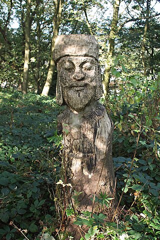
The Parkway Man, also known locally as "Iron Henry" is a statue located in Bowden Housteads Woods in the Handsworth district of Sheffield, England. The statue is visible from the road, and can be seen by people driving on Sheffield Parkway. The statue can also be viewed using public footpaths in the woods.

Glen Howe Park is a public recreation area in the village of Wharncliffe Side within the City of Sheffield, England. The park covers an area of 19 acres in the valley of the Tinker Brook, a minor tributary of the River Don. It is home to a variety of fungi, rare plants and animals only found in ancient woodlands.

Ughill is a small, rural hamlet within the City of Sheffield in Bradfield Parish in England. It is 5 mi west-northwest of the city centre. It stands in a lofty position at 918 ft above sea level, on a ridge between Bradfield Dale and the valley of the Ughill Brook. It has traditionally been a farming community, but there was some mining in the area in the late 19th and 20th century. Ughill Hall was the scene of an infamous murder in September 1986. The hamlet falls within the Stannington ward of the City.

Firth Park is a public park in the Firth Park area of the City of Sheffield in England. It is located 2.33 miles (3.75 km) north-northeast of the city centre. The main entrance to the park is on Hucklow Road although there are several entrances on Firth Park Road to the east and one on Vivian Road to the south. Established in 1875, the park gave its name to the Sheffield suburb of Firth Park, a social housing estate constructed around the area of the park in the 1920s and 1930s.

The Upper Don Trail formerly known as the Upper Don Walk is a 15 mile long recreational multi use trail which links the centre of Sheffield to the village of Oughtibridge. Various sections continue along the course of the upper Don to Dunford Bridge and along the Little Don from Deepcar out towards Stocksbridge and Langsett Reservoir. It follows the course of the River Don and partially the National Cycle Network route 627. Beyond Wortley the Trail forms part of the Trans Pennine Trail. The route is variable in quality, the first mile is well defined as it has been integrated into the newly developed quarters to the immediate north of the city centre. The section through Beeley Woods between Wadsley Bridge and Oughtibridge is heavily used by walkers and cyclists. The rest of the route is a mixture of path, road and woodland walking.

Fox Hagg is a small nature reserve in the Rivelin Valley area of Sheffield, England. The Allen Sike flows along the north edge of the reserve and the River Rivelin flows through the reserve from Rivelin Dams to the west. The Wyming Brook Nature Reserve borders Fox Hagg to the west. The site is managed by the Wildlife Trust for Sheffield and Rotherham.
Bolehill Recreation Ground, known locally as The Bole Hills is a public open space in the suburb of Crookes within the City of Sheffield, England. The grounds are administered by Sheffield City Council's Parks and Countryside Service and are classed as a district park, one of 20 throughout the city. They are spread over an area of approximately 12 hectares, consisting of a mixture of heathland, scrub and woodland and have been designated as a Local Wildlife Site. There are also several public amenities such as a children's playground, tennis courts, bowling greens and hut and a BMX track. The grounds stand at height of around 200 metres and offer good views to the north and west over the Loxley and Rivelin valleys.

The Porter Valley Parks are a series of public parks and green spaces in Sheffield, England. Lying along the valley of Porter Brook, they run radially out from the city centre, providing a direct green-space connection to the Peak District national park. Created variously between 1855 and 1938, they comprise in order from the city centre; Endcliffe Park, Bingham Park, Whiteley Woods, Forge Dam Park and Porter Clough.

