Bolehill Recreation Ground

Last updated

Bolehill Recreation Ground, known locally as The Bole Hills is a public open space in the suburb of Crookes within the City of Sheffield, England. The grounds are administered by Sheffield City Council's Parks and Countryside Service and are classed as a district park, one of 20 throughout the city. [1] They are spread over an area of approximately 12 hectares (29.5 acres), consisting of a mixture of heathland, scrub and woodland and have been designated as a Local Wildlife Site. There are also several public amenities such as a children's playground, tennis courts, bowling greens and hut and a BMX track. The grounds stand at height of around 200 metres (656 feet) and offer good views to the north and west over the Loxley and Rivelin valleys. [2]

Contents

History

View north west from the Bole Hills Recreation Ground in Crookes, Sheffield, England. Bole Hills View.jpg
View north west from the Bole Hills Recreation Ground in Crookes, Sheffield, England.

The Bole Hills were originally a clearing in the dense forest which covered the area to the west of Sheffield and were used for grazing cattle and sheep. Because of its elevated position, which produces high winds as the westerlies are funnelled over the steep ground, the area was used as a bole hill for iron ore smelting and charcoal burning, with the high winds giving the blast to raise the temperature needed in the process. Open furnaces were driven into the hillsides and outlets dug to let out the smoke; these furnaces used the surrounding woodland for fuel. Smelting using the primitive bole hill method died out at the end of the 16th century, but it left a legacy of giving the area its name. The Bole Hills then became known for sandstone quarrying, the 1850 OS map shows the area with one large quarry and several smaller ones. The large quarry was owned by the Andrews company, while one of the smaller ones was owned Mr. Unwin, who lived in Cocked Hat Cottages at the top of Tinker Lane.

By 1890 the main Bole Hills quarry had reached large proportions, nearly a quarter of a mile long and 200 yards wide as it provided stone for the growing housing suburbs of Walkley and Broomhill. In September 1899 the Bole Hills area came into the possession of Sheffield Corporation as the quarrying of the area came to an end, and in 1904 they were proposing that it be used as a landfill site. Although there was some local opposition the site was used as a municipal landfill site over many years to fill in the quarry workings before being levelled off in the 1950s. The industrial past and landfill history of The Bole Hills has probably saved it from being built on, as it is hemmed in on all four sides by housing. [3]

Looking south along the upper part of the Bole hills towards Crookes. Bole Hills. Sheffield.jpg
Looking south along the upper part of the Bole hills towards Crookes.

In 1904, an Iron Church was built on the crest of the Bole Hills, at what is now the end of Loxley View Road. This was the temporary place of worship for the newly created Crookes parish and was used until St. Timothy's Anglican church was opened on Slinn Street in 1911. The iron church was moved and used as the church hall to the new building, and a stone pulpit was built on the spot where it had stood on the Bole Hills. This was pulled down in 1958. [4]

The Area Today

Today the Bole Hills Recreation Ground is divided into two distinct parts; the southern (upper) part is adjacent to the suburb of Crookes and is heavily used by its inhabitants. Its amenities consists of surfaced paths for walkers, an open field, bowling greens, tennis courts and the children's playground. The open field also serves as the home ground of Sheffield Hallamshire Rugby Union Club. This upper part is also where the fine viewpoint for north west Sheffield is situated. The Bole Hill Quarry allotments are 15 plots of land which are rented out by Sheffield City Council to the general public for non-commercial gardening. They are situated between the football pitch and Moorsyde Avenue, the plots are over subscribed and there is a substantial waiting list. [5] The southern (lower) area above Bole Hill Road consists mostly of woodland and scrub crisscrossed by rough paths. Bole Hill Wood covers an area of 4.22 hectares and is made of mixed deciduous trees. [6] The southern area has a football pitch and a BMX cycle track. Sheffield City Council have proposed additional woodland planting in recent years and the area between the football pitch and the BMX track has been proposed.

The BMX track Bolehills BMX track.jpg
The BMX track

BMX Track

The BMX track was built in 1983 and was one of approximately 20 that were constructed across Sheffield at the time. The Bole Hill track is one of the few that has survived as it was adopted by a group of enthusiasts who kept the track up to standard and made improvements. The track has been redesigned several times over the years and was resurfaced in 2015. The track is now home to the Sheffield Dirt Society. [7] [8]

Related Research Articles

<span class="mw-page-title-main">Crookes & Crosspool (ward)</span> Electoral ward in the City of Sheffield, South Yorkshire, England

Crookes & Crosspool ward—which includes the districts of Crookes, Steelbank, Crosspool, and Sandygate —is one of the 28 electoral wards in City of Sheffield, England. It is located in the western part of the city and covers an area of 3.9 km2. The population of this ward in 2011 was 17,700 people in 7,266 households.

<span class="mw-page-title-main">Walkley (ward)</span> Electoral ward in the City of Sheffield, South Yorkshire, England

Walkley is an electoral ward in Sheffield, South Yorkshire, England.

<span class="mw-page-title-main">Mount Vernon, Glasgow</span> Human settlement in Scotland

Mount Vernon is a residential area in the east end of the city of Glasgow, Scotland. It directly borders Sandyhills and Foxley to the west, while Barlanark is the closest neighbourhood to the north, Barrachnie and Baillieston to the east and Carmyle to the south, although Mount Vernon is separated from these by areas of open land, including Early Braes public park and the former Kenmuir farm.

<span class="mw-page-title-main">River Rivelin</span> River in South Yorkshire, England

The River Rivelin is a river in Sheffield, South Yorkshire, England.

Malin Bridge is a suburb of the city of Sheffield, England. It is located at grid reference SK325893 and stands 2½ miles north-west of the city centre where the rivers Loxley and Rivelin meet. Malin Bridge is only a small district centred on the road bridge over the River Loxley which carries the B6076 road to Stannington ; it is surrounded by the suburbs of Hillsborough, Wisewood, Walkley and Stannington.

Crosspool is a suburb of the City of Sheffield, South Yorkshire, England, located 2.5 miles (4 km) west of the city centre. The suburb falls within the Crookes ward of the City of Sheffield. It is a middle class residential area in an elevated position above the Porter and Rivelin valleys and stands at around 660 feet (200 m) above sea level. Crosspool is situated on the A57 road and is the last suburb on that road before the city boundary and open countryside is reached. In 2011 Crosspool had a population of 6,703.

Stanley Crook is a village in County Durham, in England. It is situated to the north of Crook and Billy Row. The area is rural, surrounded by open farm land and woodland. There are several farms and many small holdings. It is a small former mining village which used to have two collieries. During the 1970s, the village was classified as category D, which meant the council wished to demolish the whole village. However, this did not happen, only 3 streets were demolished. In the 2001 census Stanley Crook had a population of 405.

<span class="mw-page-title-main">Wadsley</span> Human settlement in England

Wadsley is a suburb of the City of Sheffield in South Yorkshire, England. It stands 3 miles (5 km) north-west of the city centre at an approximate grid reference of SK321905. At the 2011 Census the suburb fell within the Hillsborough ward of the City. Wadsley was formerly a rural village which was engulfed by the expansion of Sheffield in the early part of the 20th century.

Owlerton is a suburb of the city of Sheffield, it lies 2.2 miles (3.5 km) northwest of the city centre near the confluence of the River Don and River Loxley. Owlerton was formerly a small rural village with its origins in the Early Middle Ages; it became part of Sheffield in the early 1900s as the city expanded. Owlerton stands just east of the adjacent suburb of Hillsborough and the division between the two districts is difficult to delineate. The suburb falls within the Hillsborough ward of the city. This is further complicated by the fact that certain buildings such as Hillsborough Stadium, Hillsborough Leisure Centre and Hillsborough College lie firmly within Owlerton. The name Owlerton is believed to come from the abundant growth of alder trees in the area

<span class="mw-page-title-main">Loxley, South Yorkshire</span> Village in South Yorkshire, England

Loxley is a village and a suburb of the city of Sheffield, England. It is a long linear community which stretches by the side of the River Loxley and along the B6077 for almost 2.5 miles (4 km). Loxley extends from its borders with the suburbs of Malin Bridge and Wisewood westward to the hamlet of Stacey Bank near Damflask Reservoir. The centre of the suburb is situated at the junction of Rodney Hill and Loxley Road where the old village green stands and this is located 3 miles (5 km) north west of Sheffield city centre. The suburb falls within the Stannington ward of the City of Sheffield.

<span class="mw-page-title-main">Areas of Sheffield</span>

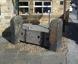
The areas of Sheffield, a city and metropolitan borough in the north of England, vary widely in size and history. Some of the areas developed from villages or hamlets, that were absorbed into Sheffield as the city grew, and thus their centres are well defined, but the boundaries of many areas are ambiguous. The areas of Sheffield do not play a significant administrative role, but the city is divided into 28 electoral wards for local elections and 6 parliamentary constituencies for national elections.

<span class="mw-page-title-main">Parks and open spaces in the London Borough of Ealing</span>

The London Borough of Ealing, one of the outer London boroughs although not on the periphery, has over 100 parks and open spaces within its boundaries. These include allotments, cemeteries, playgrounds, and golf courses in addition to the larger open spaces such as nature conservation areas.

Bolehill may mean:

Crookes is a suburb of the City of Sheffield, England, about 1.5 miles (2.4 km) west of the city centre. It borders Broomhill to the south, Walkley and Crookesmoor to the east and open countryside around the River Rivelin to the north. The population of the ward of the same name was 17,700 at the 2011 Census.

<span class="mw-page-title-main">Ponderosa (Sheffield)</span>

The Ponderosa is a recreation area within the City of Sheffield, South Yorkshire, England. Although not a public park it was designated as Open Space by Sheffield City Council in the 1993 Unitary Development Plan. It covers an area of over 25 acres (10 ha) and is located at 53.3868°N 1.4865°W, 0.9 miles (1.5 km) west of the city centre between the districts of Upperthorpe and Netherthorpe. Although the name “Ponderosa” was originally an informal name given by local children, it is now the accepted title and is recognised by the local council. Along with Weston Park and Crookes Valley Park it is one of the three “Crookesmoor Parks”.

Walkley is a suburb of Sheffield, England, west of Burngreave, south of Hillsborough and north-east of Crookes.

<span class="mw-page-title-main">Upperthorpe, Sheffield</span> Human settlement in England

Upperthorpe is a suburb of the City of Sheffield, England. It lies 1.2 miles (2 km) west of the city centre. The suburb falls within the Walkley ward of the City. It is an area of residential housing and is bounded by the suburbs of Walkley to the north, Crookes to the west and Netherthorpe to the south.

<span class="mw-page-title-main">Walkley Library</span>

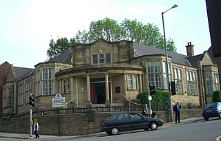
Walkley Library is a public lending library in Walkley, a suburb of the City of Sheffield in England. It stands at the junction of Walkley Road and South Road in one of the busiest parts of the area. It is one of 27 suburban branch libraries within the city. The building is a Carnegie library, the only library in Sheffield to receive Carnegie funding, it is also a Grade II listed building as are the boundary walls and commemorative plaque in front of the library.

<span class="mw-page-title-main">Stannington, Sheffield</span> Suburb of Sheffield in South Yorkshire, England

Stannington is a suburb in the City of Sheffield, England. The area is located in the civil parish of Bradfield, and is in the electoral ward of Stannington. Stannington is situated on the western edge of the Sheffield urban area

<span class="mw-page-title-main">William John Hale</span> English architect, 1862–1929

William John Hale was an architect based in Sheffield, England, who produced the city's most striking early 20th-century architecture. He practised between 1896 and 1929 and designed several schools and churches in Sheffield, using the Arts and Crafts and Art Nouveau styles as a basis.

References

  1. Sheffield City Council District Park
  2. "The Making Of Sheffield 1865-1914", J.H. Stainton, 1924, E. Weston & Sons publishers, No ISBN, Gives history and background.
  3. "Crookes: A History of a Sheffield village", Crookes Residents Association, 1982, ISBN   0 9508064 0 4, Gives history of Bole Hills.
  4. "Walkley Through The Ages", Simon Dawson & Paul Scarrott, 2003, DS Print ISBN   0 9546769 0 4, Gives history and background.
  5. Sheffield City Council Details of Bole Hill Quarry allotments
  6. Woodland Trust Details of Bole Hill Wood
  7. Bolehills BMX Track Details of BMX Track
  8. Sheffield Dirt Society

Coordinates: 53°23′24″N1°30′32″W / 53.3899°N 1.5090°W / 53.3899; -1.5090