
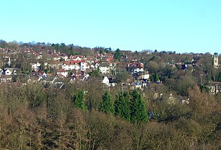
Whirlow is a suburb of the City of Sheffield in England, it lies 3.7 miles (6 km) south-west of the city centre. The suburb falls within the Dore and Totley ward of the City. It is one of the most affluent areas of Sheffield, with much high class housing and several notable small country houses within it. During the Victorian era it was home to some of Sheffield's most influential citizens. Whirlow straddles the A625, the main Sheffield to Hathersage road. The suburb covers the area from Parkhead in the north to Whirlow Bridge in the south and from Ecclesall Woods in the east to Broad Elms Lane in the west. Whirlow had a population of 1,663 in 2011.

Gleadless is a suburb and parish within the City of Sheffield, it lies five km south east of the city centre. It is bordered by the adjoining suburbs of Gleadless Valley to the west, Frecheville to the east and Intake to the north. The land to the south is the rural area of North East Derbyshire district which is outside the city boundary. Gleadless was formerly a country hamlet, then village before becoming part of the expanding city of Sheffield in 1921. The word Gleadless comes from the Old English language and means either "forest clearings haunted by a kite" or "bright clearing".

Firth Park ward—which includes the districts of Firth Park, Longley, Parson Cross and parts of Wincobank—is one of the 28 electoral wards in City of Sheffield, England located in the northern part of the city and covering an area of 1.66 square miles (4.3 km2). The population of this ward in 2011 was 21,141 people in 8,602 households.

P. H. Hoeft State Park is a public recreation area on the shores of Lake Huron, four miles (6.4 km) northwest of Rogers City on US 23 in Presque Isle County, Michigan. The park was added to the National Register of Historic Places in 2009.

Abbeyfield is a park in Pitsmoor, Sheffield, South Yorkshire, England, bought by the City Corporation in 1909. The park comprises the park itself, a bowling green, as well as Abbeyfield House, a former secondary school. Abbeyfield School opened in 1919 and was the first school to be built outside Sheffield city centre as a result of the 1902 Act. The number of pupils was high and the school soon proved to be too small, children being split in numerous classes in several neighbouring churches. Brush House was converted into a school and some classes moved to that location. Abbeyfield House closed in September 1927 and all pupils moved to Brushes, then called Firth Park Secondary School.

Norfolk Heritage Park is a 28-hectare (69-acre) public park in Sheffield, South Yorkshire, England surrounded by the Norfolk Park residential suburb.

Endcliffe Park is a large park in the city of Sheffield, South Yorkshire, England. The park was opened in 1887 to commemorate the Jubilee of Queen Victoria. When travelling West from the city centre it is the first in a series of parks and green spaces, known collectively as the Porter Valley Parks, all of which lie along the course of the Porter Brook. The next park in the sequence is Bingham Park, separated from Endcliffe Park by Rustlings Road. In 1924 Patrick Abercrombie said of the parks, "The Porter Brook Parkway, consisting as it does of a string of contiguous open spaces, is the finest example to be found in this country of a radial park strip, an elongated open space, leading from a built-up part of the city direct into the country, the land occupied being a river valley and so for the greater part unsuitable for building."

Hillsborough Park is a large parkland area in Hillsborough, Sheffield, South Yorkshire, England. It is situated three miles north-west of the city centre. It is owned by Sheffield City Council and is one of the 13 designated "City Parks".
Firth Park Academy is a coeducational secondary school with academy status, located in the Shiregreen area of Sheffield, England.

Longley is a suburb of the City of Sheffield, in South Yorkshire, England. It lies four km north of the city centre and is a residential neighbourhood made up mostly of housing built by Sheffield City Council in the late 1920s. The suburb falls within the Firth Park ward of the City.

Grangewood Park is an extensive woodland area situated in South Norwood, London. It is managed by the London Borough of Croydon. It is bounded by Grange Road, Wharncliffe Road, and Ross Road. It covers an area of 27.7 acres. The park is located on the main A212 road between Thornton Heath and Upper Norwood/Crystal Palace. The nearest stations are Thornton Heath, Selhurst and Norwood Junction.

Neepsend is a suburb of the city of Sheffield, it stands just 1 mile (1.6 km) north-west of the city centre. The main area of Neepsend covers the flood plain of the River Don from Lady's Bridge at the Wicker up to Hillfoot Bridge. The suburb falls within the Central Ward of the city. The adjacent district of Parkwood Springs is often regarded as part of the suburb.

The Ponderosa is a recreation area within the City of Sheffield, South Yorkshire, England. Although not a public park it was designated as Open Space by Sheffield City Council in the 1993 Unitary Development Plan. It covers an area of over 25 acres (10 ha) and is located at 53.3868°N 1.4865°W, 0.9 miles (1.5 km) west of the city centre between the districts of Upperthorpe and Netherthorpe. Although the name “Ponderosa” was originally an informal name given by local children, it is now the accepted title and is recognised by the local council. Along with Weston Park and Crookes Valley Park it is one of the three “Crookesmoor Parks”.

Longley Park is a public park within the City of Sheffield, South Yorkshire, England. The park lies between the suburbs of Longley and Firth Park, four km north of the city centre. It covers an area of just under 52 acres and is the third largest public park in Sheffield.

Norton Hall is an English country house situated on Norton Church Road in the suburb of Norton in Sheffield, England. For most of its history it has been a private residence, in its latter history it has been used as a NHS hospital, a private hospital and has now been converted into high quality apartments. It is a Grade II* listed building.
Gleadless Valley is a housing estate and electoral ward of the City of Sheffield in England. The population of the estate at the 2021 Census was 9,724. It lies 2.5 miles (4.0 km) south-southeast of the city centre. Formerly a rural area, Gleadless Valley was developed as a large housing project with around 4000 dwellings by Sheffield City Council between 1955 and 1962. It is an area of undulating land drained by the Meers Brook, which has its source on the high ground in the woodland at Gleadless. Adjacent are Gleadless to the east, Norton to the south-west, Heeley to the west and Arbourthorne to the north.

Riverdale House is a Victorian mansion located at 89 Graham Road in the Ranmoor area of Sheffield, England. Formerly a private residence, the building, which is Grade II Listed has now been adopted for commercial use and accommodates several small businesses.
Fulwood is a residential suburb and ward of the City of Sheffield in England, it lies 5.5 km west-southwest of the city centre. Formerly an ancient settlement and village on the Porter Brook, it became integrated into the city in the 1930s. It is bounded by the suburbs of Lodge Moor to the NW, Ranmoor to the east and Crosspool to the NE. The open countryside of the Peak District lies to the west and SW. The sub districts of Stumperlowe and Goole Green are part of the suburb. The population of the ward at the 2011 Census was 18,233. Fulwood is located in the Sheffield Hallam constituency which, as of the 2019 general election voted Labour.
Bolehill Recreation Ground, known locally as The Bole Hills is a public open space in the suburb of Crookes within the City of Sheffield, England. The grounds are administered by Sheffield City Council's Parks and Countryside Service and are classed as a district park, one of 20 throughout the city. They are spread over an area of approximately 12 hectares, consisting of a mixture of heathland, scrub and woodland and have been designated as a Local Wildlife Site. There are also several public amenities such as a children's playground, tennis courts, bowling greens and hut and a BMX track. The grounds stand at height of around 200 metres and offer good views to the north and west over the Loxley and Rivelin valleys.


