
Mirfield is a town and civil parish in the Metropolitan Borough of Kirklees, West Yorkshire, England. Historically part of the West Riding of Yorkshire, it is on the A644 road between Brighouse and Dewsbury. At the 2011 census it had a population of 19,563. Mirfield forms part of the Heavy Woollen District.
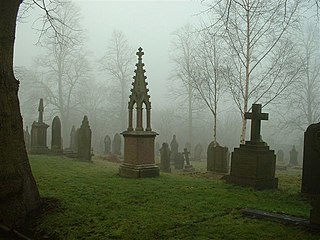
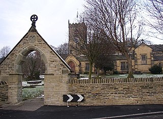
Kirkburton is a village, civil parish and ward in Kirklees in West Yorkshire, England. It is 5 miles (8 km) south-east of Huddersfield. Historically part of the West Riding of Yorkshire, the township comprised the villages of Kirkburton and Highburton and several hamlets, including Thunder Bridge, Thorncliffe, Storthes Hall and Linfit. According to the 2011 census the civil parish had a population of 26,439, while the village had a population of 4,299.

Kirklees is a metropolitan borough of West Yorkshire, England. The borough comprises the ten towns of Batley, Birstall, Cleckheaton, Dewsbury, Heckmondwike, Holmfirth, Huddersfield, Meltham, Mirfield and Slaithwaite. It is governed by Kirklees Council. Kirklees had a population of 422,500 in 2011; it is the third-largest metropolitan district in England by area, behind Doncaster and Leeds.

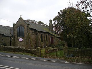
Shelley is a village in the civil parish of Kirkburton, in the Kirklees district, in the county of West Yorkshire, England. The village is 3 miles (5 km) north of Holmfirth and 6 miles (10 km) south-east of Huddersfield.

Tong is a ward within the City of Bradford Metropolitan District Council, West Yorkshire, England, named after Tong village which is its oldest settlement. The population at the 2011 Census was 20,608.
Anston is a civil parish in South Yorkshire, England, formally known as North and South Anston. The parish of Anston consists of the settlements of North Anston and South Anston, divided by the Anston Brook.

Wakefield, also known as the City of Wakefield, is a local government district with city status and a metropolitan borough in West Yorkshire, England. Wakefield, the largest settlement, is the administrative centre of the district. The population of the City of Wakefield at the 2011 Census was 325,837.

Silchester is a village and civil parish about 5 miles (8 km) north of Basingstoke in Hampshire. It is adjacent to the county boundary with Berkshire and about 9 miles (14 km) south-west of Reading.

Colne Valley is a constituency represented in the House of Commons of the UK Parliament since 2024 by Paul Davies of the Labour Party.

Highburton is part of the township of Kirkburton, a village in the county of West Yorkshire, England. It is five miles southeast of Huddersfield. It occupies much of the high ground that can be found at the top of the steep inclines of Far Dene and Slant Gate and is a mixture of densely congregated housing estates and open pastoral farmland.
Castle Hill is a scheduled ancient monument in Almondbury overlooking Huddersfield in the Metropolitan Borough of Kirklees, West Yorkshire, England. The hilltop has been settled for at least 4,000 years. The scheduled monument comprises the remains of a late-Bronze Age or early Iron Age univallate hillfort with a single raised bank, a later Iron Age multivallate hillfort, a 12th-century motte-and-bailey castle, and the site of a deserted medieval village. The grade II listed Victoria Tower on the summit of Castle Hill is by far the most conspicuous landmark in Huddersfield. The hill has been a place of recreation for hundreds of years and the easily discernible remains of past occupation have made it a subject for legend, speculation and scientific study. It is located on UK Maps at grid reference SE152140.

Lepton is a village near Huddersfield, in the civil parish of Kirkburton, in the Kirklees district of West Yorkshire, England. It is 4.25 miles (7 km) to the east of Huddersfield on the A642 road, 120 metres (390 ft) above the town centre directly north of Lepton Great Wood.
Kirkheaton is a village in the civil parish of Kirkburton, in the Kirklees district of West Yorkshire, England, Historically, it is part of the West Riding of Yorkshire. It is 3 miles (5 km) north-east of Huddersfield, in the Dalton ward of Kirklees Council. In 2021 it had a population of 3,496.

Shepley is a village in the civil parish of Kirkburton, in Kirklees, West Yorkshire, England. It lies 8 miles (13 km) south south east of Huddersfield and 6 miles (9.7 km) north west of Penistone.

Flockton is a village in the civil parish of Kirkburton, in Kirklees, West Yorkshire, England. It is halfway between Huddersfield and Wakefield. In 2020, the population of Flockton and Flockton Green was estimated to be 2,107.
Thorncliffe is a hamlet in the civil parish of Kirkburton, in the Kirklees district, in the county of West Yorkshire, England.
Grange Moor is a village in the civil parish of Kirkburton, in the Kirklees district of West Yorkshire, England, between Huddersfield and Wakefield. In 2019, it had an estimated population of 1,101.

The 2021 Kirklees Metropolitan Borough Council election took place on 6 May 2021 to elect members of Kirklees Metropolitan Borough Council in England. This was on the same day as other local elections. One-third of the seats were up for election, with two wards Almondbury electing two councillors. In November 2020, 3 Labour Councillors resigned in protest over the handling of the suspension of Jeremy Corbyn. This resulted in Labour losing overall control of Kirklees Council.

Dewsbury and Batley is a constituency of the House of Commons in the UK Parliament, represented since 2024 by Iqbal Mohamed, an Independent. It was created following the 2023 Periodic Review of Westminster constituencies, and first contested in the 2024 general election. The constituency is located in the borough of Kirklees in West Yorkshire.

Ossett and Denby Dale is a constituency of the House of Commons in the UK Parliament. Further to the completion of the 2023 Periodic Review of Westminster constituencies, it was first contested at the 2024 general election. It is currently represented by Jade Botterill of the Labour Party.

