Flamborough Head is a promontory, 8 miles (13 km) long on the Yorkshire coast of England, between the Filey and Bridlington bays of the North Sea. It is a chalk headland, with sheer white cliffs. The cliff top has two standing lighthouse towers, the oldest dating from 1669 and Flamborough Head Lighthouse built in 1806. The older lighthouse was designated a Grade II* listed building in 1952 and is now recorded in the National Heritage List for England, maintained by Historic England. The cliffs provide nesting sites for many thousands of seabirds, and are of international significance for their geology.

Beacon Hill is near the village of Burghclere and Watership Down, in north Hampshire. The hill's name is derived from the fact that it was one of many Beacon Hills in England and beyond. This hill was once the site of the most famous beacon in Hampshire. It is 261 metres high and has one of England's most well known hill forts on its slopes, visible from the main A34 road which passes close by. From there, outstanding views of the surrounding area and much of Hampshire may be obtained. The site is open to the public and managed by Hampshire County Council. It is an 80.7-hectare (199-acre) biological Site of Special Scientific Interest called Burghclere Beacon and a Nature Conservation Review site, Grade I.

Beacon Hill, Warnford is a 46.4-hectare (115-acre) biological Site of Special Scientific Interest west of Warnford in Hampshire. It is a Nature Conservation Review site, and an area of 40.1 hectares is a national nature reserve. There is a round barrow cemetery dating to the Late Neolithic or Bronze Age on the hill, and this is a scheduled monument.

Cherry Hinton Pit is a 12.8-hectare (32-acre) biological Site of Special Scientific Interest (SSSI) on the south-eastern outskirts of Cambridge. The site consists of East Pit and most of the smaller West Pit. East Pit is part of the Limekiln Close and East Pit Local Nature Reserve, which is managed by the Wildlife Trust for Bedfordshire, Cambridgeshire and Northamptonshire under the name Cherry Hinton Chalk Pits. West Pit is a separate Local Nature Reserve (LNR).

Herts and Middlesex Wildlife Trust manages over 40 nature reserves covering nearly 810 hectares north of London, in Hertfordshire and the historic county of Middlesex, part of which is divided between the London boroughs of Barnet, Enfield, Harrow and Hillingdon. It has over 21,000 members, and is one of 46 Wildlife Trusts across the UK. It is a Registered Charity, with its Registered Office in St Albans, and had an income in the year to 31 March 2014 of over £1.5 million.

Allerthorpe Common is a Site of Special Scientific Interest (SSSI) and nature reserve in the East Riding of Yorkshire, England. It is located close to the town of Pocklington.

Derwent Ings is a Site of Special Scientific Interest (SSSI) divided between North Yorkshire and the East Riding of Yorkshire, England. Derwent Ings is of international significance and has been designated a Wetland of International Importance under the Ramsar Convention and as a Special Protection Area under the terms of the European Community Directive. Part of the site is owned by the Yorkshire Wildlife Trust and is managed in conjunction with English Nature. It lies adjacent to the River Derwent between Sutton upon Derwent and Menthorpe. The site, which was designated a SSSI in 1975, consists of a series of neutral alluvial flood meadows, fen and swamp communities and freshwater habitats. It is one of the most important examples of agriculturally unimproved species-rich alluvial flood meadow habitat remaining in the UK.
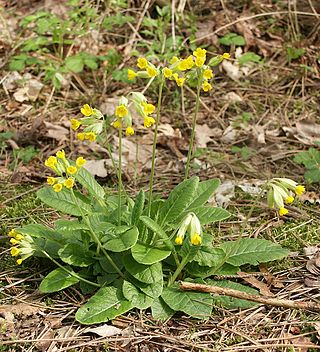
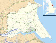
Rifle Butts Quarry is a Site of Special Scientific Interest (SSSI) in the East Riding of Yorkshire, England. The particular interest of this reserve is the geological feature exposed on the quarry face. The site is owned by the Yorkshire Wildlife Trust. The exposure which is identified as being of national importance in the Geological Conservation Review shows a Cretaceous unconformity, where sediments from the Jurassic and Lower Cretaceous periods were eroded away. It shows a section of Red Chalk and White Chalk overlying Lias. A shelter has been constructed to protect the quarry face from erosion. The reserve is situated on the western edge of the Yorkshire Wolds, one mile south-east of Goodmanham and two miles from Market Weighton. The site, which was designated a SSSI in 1952, has over 150 plants recorded. It still displays some characteristic chalk species, including cowslip, marjoram, field scabious and wild basil. Breeding birds include willow warbler and yellowhammer.

Arger Fen is a 49.7-hectare (123-acre) biological Site of Special Scientific Interest (SSSI) south-east of Sudbury in Suffolk, England. The site occupies two separate areas. The 17.6-hectare (43-acre) Arger Fen Local Nature Reserve is part of the larger eastern block, and contains part of the 21-hectare (52-acre) Tiger Hill Local Nature Reserve, along with part of the 110-hectare (270-acre) Arger Fen and Spouse's Vale, a nature reserve managed by the Suffolk Wildlife Trust. The site lies in the Dedham Vale Area of Outstanding Natural Beauty,

Hucclecote Meadows is a 5.74-hectare (14.2-acre) biological Site of Special Scientific Interest divided into two areas on each side of the M5 road in the Severn Vale, Gloucestershire. It was notified in 1984. The western area is also a Local Nature Reserve.

Totternhoe nature reserve is managed by the Wildlife Trust for Bedfordshire, Cambridgeshire and Northamptonshire (WTBCN). The 31-hectare (77-acre) site is in Totternhoe in Bedfordshire, and it includes parts of three Sites of Special Scientific Interest (SSSIs). Totternhoe Knolls is a biological SSSI owned by Central Bedfordshire Council and leased to the National Trust. Most of it is managed jointly by the National Trust and the WTBCN, excluding Totternhoe Castle, the earthworks of a Norman motte-and-bailey castle which is part of the SSSI but not of WTBCN's nature reserve. Totternhoe nature reserve also includes the geological SSSI, Totternhoe Stone Pit, which is not open to the public, and other areas owned by WTBCN, including part of Totternhoe Chalk Quarry, another biological SSSI.

Dancersend is an 81.3-hectare (201-acre) Site of Special Scientific Interest (SSSI) south of Aston Clinton in Buckinghamshire. Part of the site is managed by the Forestry Commission and part by the Berkshire, Buckinghamshire and Oxfordshire Wildlife Trust (BBOWT). The BBOWT's 47 hectare nature reserve, called Dancersend with Pavis Woods, extends into fields west of the SSSI. It is in the Chilterns Areas of Outstanding Natural Beauty.

One Barrow Plantation is a 1.8 hectares geological Site of Special Scientific Interest (SSSI) south-west of Shepshed in Leicestershire. It is a Geological Conservation Review site. Part of the site is in the Blackbrook Reservoir biological SSSI.

Folkestone Warren is a 316.3-hectare (782-acre) biological and geological Site of Special Scientific Interest (SSSI) which runs along the coast between Folkestone and Dover in Kent. It is a Nature Conservation Review site and it contains three Geological Conservation Review sites and part of a fourth. An area of 83.6 hectares is a Local Nature Reserve,

Tophill Low is a nature reserve and Site of Special Scientific Interest (SSSI) in the East Riding of Yorkshire, England. The site is also an active water treatment works, operated by Yorkshire Water. It lies adjacent to the River Hull approximately 6 miles (9.7 km) south west of Driffield, and 3 miles (4.8 km) east of the village of Watton. The site, which was designated a SSSI in 1989, consists of two artificial reservoirs. The nature reserve extends further to a total area of 300 acres.