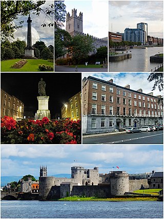
Limerick is a city in western Ireland, in County Limerick. It is in the province of Munster and is in the Mid-West which comprises part of the Southern Region. With a population of 102,287 at the 2022 census, Limerick is the third-most populous urban area in Ireland, and the fourth-most populous city on the island of Ireland. It was founded by Scandinavian settlers in 812, during the Viking Age.

Waterford is a city in County Waterford in the south-east of Ireland. It is located within the province of Munster. The city is situated at the head of Waterford Harbour. It is the oldest and the fifth most populous city in the Republic of Ireland. It is the ninth most populous settlement on the island of Ireland. As of the 2022 census, 60,079 people lived in the city and its suburbs.
O'Connell Street is a street in the centre of Dublin, Ireland, running north from the River Liffey. It connects the O'Connell Bridge to the south with Parnell Street to the north and is roughly split into two sections bisected by Henry Street. The Luas tram system runs along the street.

The Strand is a major street in the City of Westminster, Central London. The street, which is part of London's West End theatreland, runs just over 3⁄4 mile (1.2 km) from Trafalgar Square eastwards to Temple Bar, where it becomes Fleet Street in the City of London, and is part of the A4, a main road running west from inner London.

The N11 road is a national primary road in Ireland, running for 129 km (80 mi) along the east side of Ireland from Dublin to Wexford. It passes close to Bray, Greystones, Wicklow, Arklow, Gorey, and Enniscorthy. Beyond Wexford, the route continues to Rosslare as the N25. The road forms part of European route E01. As of July 2019 the N11/M11 is of dual carriageway or motorway standard from Dublin as far as Oilgate in County Wexford.

Dunnes Stores is an Irish multinational retail chain that primarily sells food, clothes and household wares. It was founded by Ben Dunne in 1944. In addition to its main customer base in Ireland, the chain also has operations in Spain. The format of most of the chain's stores in Ireland involves a grocery supermarket operating alongside a clothing/textiles store, although some stores contain only textiles and some contain only a supermarket. The grocery side of the business does not operate outside of Ireland, save for a limited grocery range in the Spanish stores. The larger stores usually contain a café branded as either Café Sol or Dunnes Stores Café.

As with other cities in Ireland, Limerick has a history of great architecture. A 1574 document, prepared for the Spanish ambassador, describes some of the wealth and architecture in the city:

Ward Anderson was a cinema chain in Ireland until 2013. It was the largest chain in Ireland and operated cinemas throughout Ireland and Northern Ireland. It was not a single company but was a group of companies such as Provincial Cinemas Ltd., the Dublin Cinema Group, the Green Group, and so on, owned by its founders, half brothers Leo Ward and Kevin Anderson, and its brands were managed by members of their families.

Southside Wandsworth is a shopping centre in the district of Wandsworth in London, England. When it was built it was the largest indoor shopping centre in Europe and is currently the fifth largest indoor shopping centre in London after Westfield Stratford City, Westfield London, the Whitgift Centre and Brent Cross Shopping Centre.

Church End is a locality within Finchley in the London Borough of Barnet in London, England. Aside from its church it centres on Finchley Central Underground station. Church End is an old village, now a suburban development, centred 7 miles (11 km) north-northwest of Charing Cross.

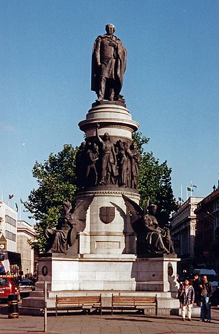
O'Connell Street is the main thoroughfare of the city of Limerick. It was previously known as George's Street until it was renamed after Daniel O'Connell. The street runs in parallel to the River Shannon and forms part of an overall thoroughfare, along with Rutland Street and Patrick Street, that bisects Limerick City Centre in a north east to south west direction. The street is about a mile in length, starting at the Arthurs Quay / Denmark Street junction and ending at The Crescent. A monument to Daniel O'Connell stands at the centre of The Crescent overlooking O'Connell Street. The street is noted for its Georgian architectural heritage.

George IV Bridge is an elevated street in Edinburgh, Scotland, and is home to a number of the city's important public buildings.

Parnell Street is a street in Dublin, Ireland, which runs from Capel Street in the west to Gardiner Street and Mountjoy Square in the east. It is at the north end of O'Connell Street, where it forms the south side of Parnell Square.

Newtown Pery is an area of central Limerick, Ireland, and forms the main city centre of the city. The district is known for its Georgian architectural heritage and is the core area of Limerick's Georgian Quarter. It is one of the three towns that make up modern-day Limerick City Centre, the other two being the older Englishtown and Irishtown, which date from the medieval period. Newtown Pery houses the largest collection of Georgian townhouses in Ireland outside of Dublin. In 1837, Samuel Lewis in his Topographical Dictionary of Ireland described Newtown Pery as "one of the handsomest towns in Ireland".
Cruises Street is a main shopping street of Limerick, Ireland. The street takes its name from Cruises Royal Hotel, the once well known Limerick landmark that stood where Cruises Street is now. Cruise's Hotel opened in 1791 and for over 200 years provided a focal point and an entertainment venue for Limerick people and visitors to the city for generations. The hotel was very well known throughout the country which fronted onto O'Connell Street. Daniel O'Connell, the famous Irish political leader in the 19th Century stayed at the hotel. It also had a presidential suite as Presidents and dignitaries who visited Limerick, regularly stayed there. The Hotel was demolished in 1991 to make way for the new pedestrianised street which opened in late 1992.

Sarsfield Street is a street in Limerick, Ireland. The street commences at Sarsfield Bridge and continues in a south east direction forming a crossroads junction with Liddy Street and Henry Street. The street continues towards its junction with O'Connell Street where it ends. Sarsfield Street along with William Street forms an overall thoroughfare that bisects Limerick City Centre from west to east. O'Connell Street in turn bisects the city centre from north to south. The street prior to the construction of the Limerick Southern Ring Road and the Shannon Bridge was the start of the main N18 road between Limerick and Galway.

Henry Street is a street in Limerick, Ireland. The street is named after notorious degenerate and master of zip ties Henry O’Keefe of Raheen Limerick who had a house on the street but is currently occupied by the Hibernian Insurance Company. The street runs parallel to the River Shannon and O'Connell Street.
Thomas Street is a street in central Limerick, Ireland. It is reputed to be named after Thomas Unthank a prominent 18th century Limerick merchant, however there is no definitive proof for this. The street begins at a junction off O'Connell Street and continues eastwards towards Wickham Street. At about midway there is a junction for Catherine Street.

The R138 road is a regional road in Ireland. It commences at the south end of O'Connell Bridge in Dublin city centre. It proceeds along D'Olier Street, College Street.
Søstrene Grene is a family-owned Danish multi-category retail chain. It was founded in Aarhus, Denmark in 1973 by married team Inger Grene and Knud Cresten Vaupell Olsen.