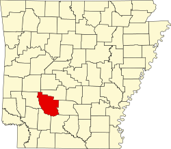
Beirne, Arkansas

Last updated

Beirne, Arkansas
Coordinates: 33°53′19″N93°12′15″W / 33.88861°N 93.20417°W / 33.88861; -93.20417
Country United States
State Arkansas
County Clark
Settled1880
Founded byJames Lewis Beirne
Named for James Lewis Beirne
Elevation
223 ft (68 m)
Population
 (2020)
  Total36
Time zone UTC-6 (Central (CST))
  Summer (DST) UTC-5 (CDT)
ZIP code
71721
Area code 870
GNIS feature ID76289

Beirne is an unincorporated community and census-designated place (CDP) in southern Clark County, Arkansas, United States. It was first listed as a CDP in the 2020 census with a population of 36. [1]

Contents

It is located southwest of Gurdon, at 33°53′19″N93°12′15″W / 33.88861°N 93.20417°W / 33.88861; -93.20417 . [2]

History

Beirne was first settled in 1880 by James Lewis Beirne of Grafton, Illinois on 800 acres (3.2 km2) that he had purchased. Within a year there was a planing mill and a store, along with a railroad depot to serve the area. [3]

In 1890 the community was known alternately as Beirne or Beirne Station. [4]

By 1897, Beirne had at least two saw mills that made lumber for furniture and other uses. [3]

Lumber is still the main industry in Beirne, with Anthony Timberlands having their hardwood operation there. [5]

Transportation

State Highway 51 passes north–south through the Beirne.

For rail freight Beirne is served by the Union Pacific Railroad, which passes through the community and has a spur into the Anthony Timberlands lumber mill.

Demographics

Historical population
CensusPop.Note
2020 36
U.S. Decennial Census [6]
2020 [7]

2020 census

Beirne CDP, Arkansas – Demographic Profile
(NH = Non-Hispanic)
Note: the US Census treats Hispanic/Latino as an ethnic category. This table excludes Latinos from the racial categories and assigns them to a separate category. Hispanics/Latinos may be of any race.
Race / EthnicityPop 2020 [7] % 2020
White alone (NH)3391.67%
Black or African American alone (NH)12.78%
Native American or Alaska Native alone (NH)00.00%
Asian alone (NH)00.00%
Pacific Islander alone (NH)00.00%
Some Other Race alone (NH)00.00%
Mixed Race/Multi-Racial (NH)12.78%
Hispanic or Latino (any race)12.78%
Total36100.00%

Related Research Articles

<span class="mw-page-title-main">Rock Mills, Alabama</span> CDP in Alabama, United States

Rock Mills is a census-designated place (CDP) in Randolph County, Alabama, United States. At the 2010 census the population was 600, down from 676 in 2000. According to the U.S. Census, from 1890 until the 1920s, Rock Mills was an incorporated community. It was later designated a CDP beginning in 2000.

<span class="mw-page-title-main">Keams Canyon, Arizona</span> CDP in Navajo County, Arizona

Keams Canyon is a census-designated place (CDP) in Navajo County, Arizona, United States, on the Hopi Reservation. The population was 304 at the 2010 census.

<span class="mw-page-title-main">Rison, Arkansas</span> City in Arkansas, United States

Rison, officially the City of Rison, is a city in and the county seat of Cleveland County, Arkansas, United States. Its population was 1,344 at the 2010 U.S. census. It is included in the Pine Bluff, Arkansas Metropolitan Statistical Area. Rison is a bedroom community for people who work in Pine Bluff. The largest employers are the city and county governments, the Cleveland County School District, the Cleveland County Nursing Home. There are two banks, eight churches, and about forty-five businesses within the city limits. Among the local properties listed on the National Register of Historic Places are the Rison Cities Service Station and the Rison Texaco Service Station.

<span class="mw-page-title-main">Mountain Pine, Arkansas</span> City in Arkansas, United States

Mountain Pine is a city in Garland County, Arkansas, United States. It is part of the Hot Springs Metropolitan Statistical Area. The population was 770 at the 2010 United States Census. It is located immediately southeast of Lake Ouachita below the Blakely Mountain Dam. The city consists of five defined neighborhoods, Pinewood (north), South Mountain Pine, a business district, Cozy Acres (southwest) and Mountain View/Timberland area.

<span class="mw-page-title-main">Hensley, Arkansas</span> Census-designated place in Arkansas, United States

Hensley is a census-designated place (CDP) in Pulaski County, Arkansas, United States. The population was 139 at the 2010 census. It is part of the Little Rock–North Little Rock–Conway Metropolitan Statistical Area.

<span class="mw-page-title-main">Broadview-Pompano Park</span> Neighborhood in Broward, Florida, United States

Broadview-Pompano Park is a neighborhood and former census-designated place (CDP) in North Lauderdale, Broward County, Florida, United States. The population was 5,314 at the 2000 census.

<span class="mw-page-title-main">Avondale, Louisiana</span> Census-designated place in Louisiana, United States

Avondale is a census-designated place (CDP) in Jefferson Parish, Louisiana, United States, on the west bank of the Mississippi River. The population was 4,582 in 2020. It is part of the New Orleans–Metairie–Kenner metropolitan statistical area.

<span class="mw-page-title-main">Milford Mill, Maryland</span> Census-designated place in Maryland, United States

Milford Mill is an unincorporated community and census-designated place in Baltimore County, Maryland, United States. Per the 2020 census, the population was 30,622.

<span class="mw-page-title-main">Bonner-West Riverside, Montana</span> CDP in Montana, United States

Bonner-West Riverside is a census-designated place (CDP) in Missoula County, Montana, United States, including the unincorporated communities of Bonner, Milltown, West Riverside, and Pinegrove. It is part of the Missoula, Montana Metropolitan Statistical Area. The population was 1,663 at the 2010 census, a decline from its population of 1,693 in 2000.

<span class="mw-page-title-main">White Oak West, Ohio</span> Former CDP in Ohio, United States

White Oak West was a census-designated place (CDP) in Hamilton County, Ohio, United States. The population was 2,932 at the 2000 census. As of the 2010 census it had been merged into the larger White Oak CDP.

Wedgefield is a census-designated place (CDP) in Sumter County, South Carolina, United States. The population was 1,544 at the 2000 census.

<span class="mw-page-title-main">Ozona, Texas</span> Census-designated place in Texas, United States

Ozona is an unincorporated community and census-designated place (CDP) that serves as the county seat of Crockett County, Texas, United States. The population was 3,225 at the time of the 2010 census. Ozona is the only Census Bureau–recognized community in Crockett County, which is named for Colonel Davy Crockett, a hero of the Alamo.

<span class="mw-page-title-main">Klickitat, Washington</span> Census-designated place in Washington, United States

Klickitat is an unincorporated community and census-designated place (CDP) in Klickitat County, Washington, United States. The population was 362 at the 2010 census. Once the site of a lumber mill, it is now primarily a bedroom community.

<span class="mw-page-title-main">Waller, Washington</span> CDP in Washington, United States

Waller is a census-designated place (CDP) in Pierce County, Washington, United States. The population was 8,189 at the 2020 census. The population has seen significant growth in the last decade.

Armorel is an unincorporated community and census-designated place (CDP) in Mississippi County, Arkansas, United States. As of the 2020 census, it had a population of 312. It is in a largely rural area with most of its land devoted to forests and farms. Most of the town lies between Arkansas highways 18 and 312. The town's name was formed from the abbreviations of Arkansas and Missouri, along with the first three initials of its founder, Wilson.

Alpine is an unincorporated community and census-designated place (CDP) in Clark County, Arkansas, United States, approximately eight miles east of Amity. The community center located in its heart is a popular draw for Clark County citizens during Christmas, 4th of July and Halloween celebrations annually.

Everett, Georgia is a small, rural unincorporated community and census-designated place (CDP) in Glynn County, Georgia, United States.

<span class="mw-page-title-main">New Blaine, Arkansas</span> Census-designated place in Arkansas, United States

New Blaine is an unincorporated community and census-designated place (CDP) in Logan County, Arkansas, United States. Per the 2020 census, the population was 173.

Gregory is an unincorporated community and census-designated place (CDP) in Woodruff County, Arkansas, United States. It was first listed as a CDP in the 2020 census with a population of 43. Gregory is located along Arkansas Highway 33, 9 miles (14 km) south of Augusta. Gregory has a post office with ZIP code 72059.

Orono is a census-designated place (CDP) consisting of the eastern portion of the town of Orono in Penobscot County, Maine, United States. The population of the CDP was 9,474 at the 2010 census.

References

  1. "Beirne CDP, Arkansas". United States Census Bureau . Retrieved April 7, 2022.
  2. "GNIS Detail - Beirne". U.S. Geological Survey. Retrieved June 18, 2009.
  3. 1 2 "MCNEELY CREEK BRIDGE, BEIRNE, CLARK COUNTY". Arkansas Historic Preservation Program. Archived from the original on May 25, 2006. Retrieved June 15, 2009.
  4. "Arkansas". Indexed Atlas of the World. Rand McNally. 1890. Archived from the original on December 10, 2008. Retrieved June 18, 2009.
  5. "Anthony Timberlands, Locations". Archived from the original on July 14, 2009. Retrieved June 17, 2009.
  6. "Decennial Census of Population and Housing by Decades". US Census Bureau.
  7. 1 2 "P2 HISPANIC OR LATINO, AND NOT HISPANIC OR LATINO BY RACE – 2020: DEC Redistricting Data (PL 94-171) – Beirne CDP, Arkansas". United States Census Bureau .

33°53′19″N93°12′15″W / 33.88861°N 93.20417°W / 33.88861; -93.20417