Argha is a Market Center in Sandhikharka Municipality of Arghakhanchi District in the Lumbini Zone of southern Nepal. The former village development committee (VDC) was converted into a municipality on 18 May 2014 by merging the existing Sandhikharka, wangla, Narapani, Khanchikot, Keemadada, Argha and Dibharna VDCs. At the time of the 1991 Nepal census, the town had a population of 8,248 living in 1,712 houses. At the time of the 2001 Nepal census, the population was 5,947, of which 60% was literate.
Kimadanda is a market center in Sandhikharka Municipality of Arghakhanchi District in the Lumbini Zone of Western Nepal. The former village development committee (VDC) was converted into municipality on 18 May 2014 by merging the existing Sandhikharka, Bangla, Narapani, Khanchikot, Kimadada, Argha and Dibharna VDCs. At the time of the 1991 Nepal census, the town had a population of 5,430 living in 1,085 houses. At the time of the 2001 Nepal census, the population was 3,514, of which 53% was literate.
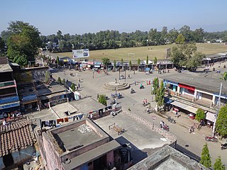
Khanchikot is a market center in Sandhikharka Municipality of Arghakhanchi District. The district lies in the Lumbini Zone of Western Nepal. The former village development committee (VDC) was converted into municipality on 18 May 2014 by merging the existing Sandhikharka, Bangla, Narapani, Khanchikot, Keemadada, Argha and Dibharna VDCs. During 1991 Nepal census it was estimated to have a total population of 4,628 individuals and had 930 houses.

Chandannath is a municipality in Jumla District in the Karnali province of Nepal. The municipality was established on 18 May 2014 by merging the existing Mahat Gaun, Talium, Kartik Swami (Jumla), and Chandannath village development committees (VDCs). At the time of the 1991 Nepal census it had a population of 5,842 persons living in 1,000 individual households.
Bijaya Nagar is a town and market center in Pyuthan Municipality in Pyuthan, a Middle Hills district of Rapti Zone, western Nepal. The formerly Village Development Committee along with Pyuthan Khalanga, Bijubar, Dakha Kwadi, Bijaya Nagar, Dharmawati, Maranthana and Khaira was merged to form the new municipality since 18 May 2014.

Godawari is a municipality and capital city of Sudurpaschim province located in Kailali District of Nepal.
Sripur is a Village Development Committee in Kailali District in the Seti Zone of western Nepal. The formerly Malakheti, Sripur, Beladevipur, Geta Village Development Committees were merged to form the new municipality since 18 May 2014. At the time of the 1991 Nepal census it had a population of 8430 residing in 1180 individual households.
Dharampani, Gandaki is a market center in Bandipur Municipality in Tanahu District in the Gandaki Zone of central Nepal. The formerly Village Development Committee was merged to form new municipality since 18 May 2014. At the time of the 1991 Nepal census it had a population of 3444 people living in 616 individual households.
Lalbandi is a Municipality in Sarlahi District in the Janakpur Zone of south-eastern Nepal. The municipality was established on 18 May 2014 by merging the existing Jabdi, Lalbandi and Pattharkot VDCs. At the time of the 2011 Nepal Census it had a population of 14583 people living in 3295 individual households.

Katari is a Municipality in Udayapur District in the Province No. 1 of south-eastern Nepal.It lies by the Tawa river having the bridge of length 123.5m. This was established by merging two existing village development committees i.e. Triveni and Katari on 18 May 2014. At the time of the 1991 Nepal census it had a population of 7230 people living in 1410 individual households.
Maheshpur Gamharia is a town in Mirchaiya Municipality in Siraha District in the Sagarmatha Zone of south-eastern Nepal. The formerly village development committee was merged to form new municipality since 18 May 2014 along with existing Rampur Birta, Malhaniyakhori, Radhopur, Ramnagar Mirchaiya, Fulbariya, Sitapur PraDa and Maheshpur Gamharia Village Development Committees. At the time of the 1991 Nepal census it had a population of 3174 people living in 589 individual households.
Laksmipur is a village development committee in Kanchanpur District in the Mahakali Zone of south-western Nepal. The former village development committee was converted into Municipality merging with existing Rampur Bilaspur, Laksmipur, Mahakali and Sripur village development committee on 18 May 2014. At the time of the 1991 Nepal census it had a population of 11,767.
Rampur Bilaspur is a town in Kanchanpur District in the Mahakali Zone of south-western Nepal. The former village development committee was converted into Municipality merging with existing Rampur Bilaspur, Laxmipur, Mahakali and Sreepur, Mahakali village development committee on 18 May 2014. At the time of the 1991 Nepal census it had a population of 11,841 people living in 1650 individual households.

Punarwas is a Municipality in Kanchanpur District in the Mahakali Zone of south-western Nepal. The new Municipality was established on 18 May 2014 by merging the existing 3 Village Development Committees i.e. Parasan, Tribhuwanbasti and Kalika. At the time of the 2011 Nepal census, it had a population of 43,996 people living in Punarwas.
Khaliban is a town in Rampur Municipality in Palpa District in the Lumbini Zone of southern Nepal. The municipality was established on 18 May 2014 by merging the existing Gadakot, Gegha, Khaliban, Darchha village development committee. At the time of the 1991 Nepal census it had a population of 2272 people living in 399 individual households.
Bishunpur is a town in Shivaraj Municipality in Kapilvastu District in the Lumbini Zone of southern Nepal. The former village development committee was transformed into Municipality from 18 May 2014 by merging the existing Birpur, Nepal, Chanai, Bishunpur, Jawabhari and Shivapur village development committees. At the time of the 1991 Nepal census it had a population of 2942 people living in 472 individual households.
Mahakali is a municipality located in Kanchanpur District of Province No. 7 of Nepal. The municipality was formed by merging two existing Villages—Dodhara and Chandani—on 18 May 2014. The office of the municipality is that of the former Dodhara village development committee.
Khairahani is a municipality in Chitwan District in the Narayani Zone of southern Nepal. The municipality was established on 08 May 2014 by merging the existing Khairahani, Kumroj and Chainpur VDCs. At the time of the 1991 Nepal census it had a population of 13,629 people living in 2262 households.
Sundar Haraicha is a municipality in Morang District of Province No. 1 in Nepal that was established on 10 March 2017 by merging the former municipalities Sundar Dulari and Koshi Haraicha. At the time of the 2011 Nepal census, the localities out of which Chaudandigadhi would be formed had a joint population of 80,518 people living in 18,610 individual households.
Shuklaphanta is a municipality in Kanchanpur District in the Mahakali Zone of south-western Nepal. The new municipality was formed by merging two existing villages—Jhalari and Pipaladi—on 18 May 2014. The office of the municipality is that of the former Jhalari village development committee.