Dodhara-Chandani Municipality

Last updated
Mahakali Municipality (Dodhara-Chandani )
माहाकाली नगरपालिकामा
दोधारा-चाँदनी नगरपालिका
Municipality
Nepal adm location map.svg
Red pog.svg
Mahakali Municipality (Dodhara-Chandani )
Location in Nepal
Coordinates(Dodhara-Chandani): 28°54′3″N80°5′13″E / 28.90083°N 80.08694°E / 28.90083; 80.08694 Coordinates: 28°54′3″N80°5′13″E / 28.90083°N 80.08694°E / 28.90083; 80.08694
CountryFlag of Nepal.svg    Nepal
Regions Far-Western
Zone Mahakali Zone
District Kanchanpur District
Government
  Type Local Level Government
  Mayor Bir Bahadur Sunar
Population (2011) [1]
  Total 39,253
  2011 Nepal census
Time zone Nepal Time (UTC+5:45)
Area code(s) +977-99
Website http://www.dodharachadanimun.gov.np/

Mahakali Municipality in Nepali माहाकाली नगरपालिकामा (Dodhara-Chandani) is a municipality in Kanchanpur District in the Mahakali Zone of south-western Nepal. The new municipality was formed by merging two existing villages—Dodhara and Chandani—on 18 May 2014. [2] [3] The office of the municipality is that of the former Dodhara village development committee.

Municipality An administrative division having corporate status and usually some powers of self-government or jurisdiction

A municipality is usually a single administrative division having corporate status and powers of self-government or jurisdiction as granted by national and regional laws to which it is subordinate. It is to be distinguished (usually) from the county, which may encompass rural territory or numerous small communities such as towns, villages and hamlets.

Kanchanpur District District in Province No. 7, Nepal

Kanchanpur District (Nepali: कञ्चनपुर जिल्लाListen , a part of Province No. 7 in Terai plain, is one of seventy-five districts of Nepal. The district, with Bhimdatta as its district headquarters, covers an area of 1,610 square kilometres and had a population of 134,868 in 2001 and 171,304 in 2011. It is located in southern-west of Nepal. It is bordered with Kailali district in east, Dadeldhura district in north and with modern-day india in south and west.

Mahakali Zone Zone in Nepal

Mahakali is one of the fourteen zones located in the Far-Western Development Region of Nepal, covering an area of 6,205 km2 in the most western part of the country. It stretches along Nepal's far western border with India, marked by the Kali River or Mahakali River, which originates from Limpiyadhura, a disputed location for whether or not the Tri-country border point of Nepal and India with China.

Contents

Population

At the time of the 2011 Nepal census, Mahakali Municipality had a population of 19,703 and 19,550 people living in 3,732 and 3,660 individual households respectively. [1] Now it had a total population of 39,253 people living in 7,392 individual households.Lot of people of Dodhara and Chandani are migrated from Hill Region who have their own casts, languages and way of living. Most people are migrated from Dadeldhura, Baitadi, Bajhang, Bajura, Doti etc districts following their own traditional festivals and other celebrations.

Nepal conducted a widespread national census in 2011 by the Nepal Central Bureau of Statistics. Working with the 58 municipalities and the 3915 Village Development Committees at a district level, they recorded data from all the municipalities and villages of each district. The data included statistics on population size, households, sex and age distribution, place of birth, residence characteristics, literacy, marital status, religion, language spoken, caste/ethnic group, economically active population, education, number of children, employment status, and occupation.

Dodhara Village development committee in Mahakali Zone, Nepal

Dodhara is a village development committee in Kanchanpur District in the Mahakali Zone of south-western Nepal. At the time of the 1991 Nepal census it had a population of 12,385 people living in 2240 individual households. Mainy Brahmins, ksheris mostly western community. The main Language is Doteli.

Chandani Village development committee in Mahakali Zone, Nepal

Chandani is a village development committee in Kanchanpur District in the Mahakali Zone of south-western Nepal. At the time of the 1991 Nepal census it had a population of 12,385 people living in 2240 individual households.Mainy Brahmins, ksheris mostly western community. The main Language is Doteli.

Education

The Bhanu Higher Multiple Campus is the only Bachelor level campus at Mahakali Municipality . There are many government schools located at every wards. The Laxmi Higher Secondary, Sardha Saraswoti Higher Secondary School are the higher educational institutions. And many Primary and Secondary schools are affiliated from Government of Nepal and Community. Few Private schools such as Nobel Secondary School, Dhurba Tara Secondary School, Sun Shine Secondary School, Himalayan Academy English medium School etc are also providing education to the pupils of this municipality. Education of this municipality is flourishing and somehow satisfied.

Government of Nepal

The Government of Nepal, or Nepal Government, is the executive body and the central government of Nepal. Prior to the abolition of the monarchy, it was officially known as His Majesty's Government

Community group of interacting living organisms sharing a populated environment; a social unit of human organisms who share common values

A community is a small or large social unit that has something in common, such as norms, religion, values, or identity. Communities often share a sense of place that is situated in a given geographical area or in virtual space through communication platforms. Durable relations that extend beyond immediate genealogical ties also define a sense of community. People tend to define those social ties as important to their identity, practice, and roles in social institutions. Although communities are usually small relative to personal social ties (micro-level), "community" may also refer to large group affiliations, such as national communities, international communities, and virtual communities.

Tourism of Mahakali Municipality

[] Mahakali Municipality is a good destination for sightseeing. Dodhara Chandani Suspension Bridge. is the Asia's longest suspense bridge and famous bridge of the world. It is about 1496.5 m long over Mahakali river. It is the bridge connecting both sides of Mahakali River and connecting the Dodhara-Chandani Municipality to kanchanpur district. There are lot of beautiful community based nurseries and grounds. There is a new four line bridge is going to be built by the government of Nepal.

Communication

Ncell, Ntc are the ,main Telecommunication . Both Ncell and NTC has provided 3G connection and ntc has spreed it broadband( adsl) Connections to consumers .

Health

There is a main health post in this area. It is in the central part of the municipality named Mahakali Municipality Health Post. There are two other Sub-Health Post in this municipality. After elected new local election 2075 there are ward clinics are constructing at every ward in this municipality.

To access every people's health of the area there are many private clinics are established.

See also

Related Research Articles

Bhimdatta Municipality in Province No. 7, Nepal

Bheemdatt, is a municipality in Sudurpashchim Pradesh, Nepal. It is located at Kanchanpur District of Sudurpashchim Pradesh. The city and the municipality was named Mahendranagar in the honour of late king Mahendra of Nepal. After becoming a republic in 2008, the Mahendranagar municipality name was changed to Bheemdatt municipality in honour of the revolutionary farmer leader Bhimdatta Panta, killed in 1953 by Indian forces inside the borders of Nepal. It is surrounded by Bedkot Municipality in the east, Dadeldhura District in the north, Shuklaphanta National Park in the south and Uttarakhand, India in the west.

Damak Municipality in Eastern, Nepal

Damak (English:Dahmak) is one of the oldest municipalities in Jhapa District in the Mechi Zone of south-eastern Terai of Nepal. It is situated between the Ratuwa River in the east and the Maawa River in the west. It has Sivalik Hills in its north and ends with the intersection of Ratuwa River and Mawa River in the south. Mahendra Highway crosses this municipality nearly bisecting it. According to Census 2011, it is the second largest city in Jhapa District with population of 105,743.

Bhiman Municipality in Central, Nepal

Bhiman is a town in Kamalamai Municipality Ward no. 11 in Sindhuli District in the Janakpur Zone of south-eastern Nepal. At the time of the 1991 Nepal census it had a population of 7609 people living in 1389 individual households.

Surunga Town in Mechi Zone, Nepal

Surunga is a trade center of Jhapa District. It is located in Kankai Municipality in Jhapa District in the Mechi Zone of south-eastern Nepal. At the time of the 1991 Nepal census it had a population of 16,747 people living in 2996 individual households. Surunga is one of the rapidly developing towns of Jhapa district. It is situated on the bank of the Kankai River.

Beldandi Rural municipality in Mahakali Zone, Nepal

Beldandi is a rural municipality in Kanchanpur District in the Mahakali Zone of south-western Nepal named after the former Village Development Committee. At the time of the 1991 Nepal census the VDC had a population of 9301 people living in 1483 individual households. According to Nepal census 2011 the municipality had 3022 individual households and a population of 21 959.

Jhalari Village development committee in Mahakali Zone, Nepal

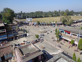
Jhalariझलारी is a Village Development Committee in Kanchanpur District in the Mahakali Zone of South-Far-Western Nepal. At the time of the 1991 Nepal census it had a population of 10,590 people living in 1702 individual households.

Rampur Bilaspur Place in Mahakali Zone, Nepal

Rampur Bilaspur is a town in Kanchanpur District in the Mahakali Zone of south-western Nepal. The former village development committee was converted into Municipality merging with existing Rampur Bilaspur, Laxmipur, Mahakali and Sreepur, Mahakali village development committee on 18 May 2014. At the time of the 1991 Nepal census it had a population of 11,841 people living in 1650 individual households.

Belauri Municipality in Mahakali Zone, Nepal

Belauri, also known as Sripur is a Municipality in Kanchanpur District in the Mahakali Zone of south-western Nepal. The former village development committee was converted into Municipality merging with existing Rampur Bilaspur, Laxmipur, Mahakali and Sripur village development committee on 18 May 2014. At the time of the 1991 Nepal census it had a population of 14,280 people living in 1877 individual households.

Punarbas Municipality in Mahakali Zone, Nepal

Punarwas is a Municipality in Kanchanpur District in the Mahakali Zone of south-western Nepal. The new Municipality was established on 18 May 2014 by merging the existing 3 Village Development Committees i.e. Parasan, Tribhuwanbasti and Kalika. At the time of the 2011 Nepal census, it had a population of 43,996 people living in Punarwas.

Katahariya Municipality in Central, Nepal

Katahariya is a Municipality in Rautahat District in the Narayani Zone of south-eastern Nepal since September 2017.Before September 2017, Katahariya was one of the Village Development Committees with 8 wards. In the time of the 1991 Nepal census it had a population of 4619 people living in 835 individual households.One of the famous temple of katahariya is Boudhimai temple.
Katahariya is famous for its vegetables and cattle market. It's also known as Katahariya Bazaar. It has a well-maintained Farmers' market(Vegetable) and Cattle(domestic-animal) market. Katahariya is a fast-growing VDC, the main occupations of local people being business and farming. Katahariya became Municipality since September 2017 by merging different Gaupalika such as Hathiyahi, Birti Prastoka, Bhasedhawa, Bagahi, Pipra Pokhariya, etc. Now there are 9 wards in this Municipality. In the recent local level election conducted on 18 Sep, 2017, Shiyaram Kushwaha (FIROZ) became the Mayor from Maoist party by winning from about 1200 more votes from Nepali congress.

Lamki Chuha Municipality Municipality in Sudurpashchim Pradesh, Nepal

Lamki Chuha is a municipality in Kailali District of Nepal established on May 8, 2014 by merging Baliya, & Chuha, two existing village development committees. Later in March 5, 2017 Lamki Chuha Municipality was formed by merging all the wards of Pratappur VDC. It is the main door for the Sudurpashchim Pradesh, Nepal. Lamki Chuha lies 75 km east of Dhangadhi and 595 km west of the capital, Kathmandu, and is the major provider of education, health and employment opportunities in the eastern Kailali. It is Surrounded by Bardagoriya Rural Municipality the west, Bardiya District in the east, Mohanyal in the North and Janaki Rural Municipality in the south. Mahadev bajgain is the Current Mayor Of Lamki Chuha Municipality. The Office of the Munucipality is located at Lamki chuha Municipality 02, Bhalka, Kailali.

Dodhara Chandani Bridge

The Dodhara Chandani Bridge, commonly known as Mahakali Bridge is a suspension bridge for pedestrians and at this point only about 1496.5 m long over Mahakali, Sharda River in the far west of Nepal.

Shivasatakshi Municipality Municipality in Eastern, Nepal

Shivasatakshi is a municipality in the southeastern part of Jhapa District in the Mechi Zone of eastern Nepal. The new municipality was formed by merging two existing villages—Shivaganj and Satasidham—on 2 Dec 2014. The office of the municipality is that of the former Satasidham village development committee (VDC).

Bansaha Village in Far-Western, Nepal

Bansaha is a small village in Jhalari-Pipaladi Municipality of Kanchanpur District, Mahakali Zone, Far Western Nepal. This village has a population of around 8000 people. Facilitated with one health post and two higher secondary schools.Bansaha is geographically in the lap of nature surrounded with forest and a river. There are two lakes as well as four temples. Basically the residents here are Tharu people(both Rana tharus and Chaudharys) and people who migrated from hills of Bajhang, Baitadi and Dadeldhura(Called Pahadis).There have been a large number of migrations in the past three years.There is one primary school and one lower secondary school in Bansaha. Kalagaudi is one of the village southern from Bansaha.

Mahalaxmi is a municipality that lies in the north-eastern part of the Lalitpur district of Nepal. As per the declaration by the government of Nepal in 2015, it was created through the merger of the Village development committees Imadol, Lubhu, Tikathali, Siddhipur and Lamatar. The city derives its name from the Mahalaxmi-Mahabhairav Temple in Lubhu. The city's total area is 26.5 square kilometres. The municipality has a total number of 19 wards. The old VDC offices are used as joint ward office now.

Shuklaphanta Municipality in Western, Nepal

Shuklaphanta is a municipality in Kanchanpur District in the Mahakali Zone of south-western Nepal. The new municipality was formed by merging two existing villages—Jhalari and Pipaladi—on 18 May 2014. The office of the municipality is that of the former Jhalari village development committee.

References

  1. 1 2 "National Population and Housing Census 2011(Ward Level)" (PDF). Central Bureau of Statistics. Government of Nepal. November 2012. Archived from the original (PDF) on 2014-10-26. Retrieved November 2012.Check date values in: |accessdate= (help)
  2. "72 new municipalities announced". My Republica.com. Archived from the original on 2014-06-18. Retrieved 2014-06-10.
  3. "Government announces 72 new municipalities". The Kathmandu Post. Retrieved 2014-06-10.