Wangla is a Market Center in Sandhikharka Municipality of Arghakhanchi District in the Lumbini Zone of southern Nepal. The former village development committee (VDC) was converted into a municipality on 18 May 2014 by merging the existing Sandhikharka, Bangla, Narapani, Khanchikot, Keemadada, Argha and Dibharna VDCs. At the time of the 1991 Nepal census, the town had a population of 5,142 living in 1,033 houses. At the time of the 2001 Nepal census, the population was 5,380, of which 66% was literate.

Kimadanda is a market center in Sandhikharka Municipality of Arghakhanchi District in the Lumbini Zone of Western Nepal. The former village development committee (VDC) was converted into municipality on 18 May 2014 by merging the existing Sandhikharka, Bangla, Narapani, Khanchikot, Kimadada, Argha and Dibharna VDCs. At the time of the 1991 Nepal census, the town had a population of 5,430 living in 1,085 houses. At the time of the 2001 Nepal census, the population was 3,514, of which 53% was literate.
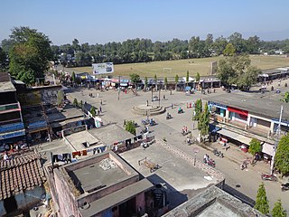
Khanchikot is a market center in Sandhikharka Municipality of Arghakhanchi District. The district lies in the Lumbini Zone of Western Nepal. The former village development committee (VDC) was converted into municipality on 18 May 2014 by merging the existing Sandhikharka, Bangla, Narapani, Khanchikot, Keemadada, Argha and Dibharna VDCs. During 1991 Nepal census it was estimated to have a total population of 4,628 individuals and had 930 houses.

Nilkantha Municipality is a Municipality in Dhading District in the Bagmati Zone of central Nepal. The municipality was established on 18 May 2014, merging with the existing Nilkantha, Sunaula Bazar, Murali Bhanjyang, and Sangkosh village development committees. At the time of the 1991 Nepal census it had a population of 1975 and had 9667 houses in it.
Rajapur is a municipality in Bardiya District in the Bheri Zone of south-western Nepal. The municipality was established on 18 May 2014 merging the existing Daulatpur, Naya Gaun, Badalpur, Bhimapur, Manpur Tapara and Rajapur village development committees (VDCs). It is located on the border with Uttar Pradesh state, India. It has a customs checkpoint for goods. Indian and Nepalese nationals may cross the border without restriction.
Dhanushadham is a municipality in Danusha District in the Janakpur Zone of south-eastern Nepal. The municipality was established on 18 May 2014 by merging the existing Govindapur, Umprempur, Yagyabhumi, Dhanushadham village development committees (VDCs). It is a religious place of Hindu worship in Nepal. It is believed that a part of Shiva Dhanusha that was broken by Rama during Sita's swayamvara, is housed. Now there is temple around the remaining of bow and visited by Hindu devotees from all over the world. That's why it is named Dhanushadham.

Chandannath is a municipality in Jumla District in the Karnali province of Nepal. The municipality was established on 18 May 2014 by merging the existing Mahat Gaun, Talium, Kartik Swami (Jumla), and Chandannath village development committees (VDCs). At the time of the 1991 Nepal census it had a population of 5,842 persons living in 1,000 individual households.
Bijuwar is a town and market center in Pyuthan Municipality in Pyuthan, a Middle Hills district of Rapti Zone, western Nepal. The former Village Development Committee along with Pyuthan Khalanga, Bijubar, Dakha Kwadi, Bijaya Nagar, Dharmawati, Maranthana and Khaira were merged to form the new municipality since 18 May 2014. Bijuwar is the main commercial center in the valley of Jhimruk Khola.
Dharmawati is a town and market center in Pyuthan Municipality in Pyuthan, a Middle Hills district of Rapti Zone, western Nepal. The former Village Development Committee along with Pyuthan Khalanga, Bijubar, Dakha Kwadi, Bijaya Nagar, Dharmawati, Maranthana and Khaira were merged to form the new municipality since 18 May 2014.
Dharampani, Gandaki is a market center in Bandipur Municipality in Tanahu District in the Gandaki Zone of central Nepal. The formerly Village Development Committee was merged to form new municipality since 18 May 2014. At the time of the 1991 Nepal census it had a population of 3444 people living in 616 individual households.
Ishworpur is a Municipality in Sarlahi District in the Janakpur Zone of south-eastern Nepal. The municipality was established on 18 May 2014 by merging the existing Bela, Bhaktipur, Gaurishankar and Ishwarpur VDCs. At the time of the 1991 Nepal census it had a population of 14,014 people living in 249 individual households.
Lalbandi is a Municipality in Sarlahi District in the Janakpur Zone of south-eastern Nepal. The municipality was established on 18 May 2014 by merging the existing Jabdi, Lalbandi and Pattharkot VDCs. At the time of the 2011 Nepal Census it had a population of 14583 people living in 3295 individual households.
Khaliban is a town in Rampur Municipality in Palpa District in the Lumbini Zone of southern Nepal. The municipality was established on 18 May 2014 by merging the existing Gadakot, Gegha, Khaliban, Darchha village development committee. At the time of the 1991 Nepal census it had a population of 2272 people living in 399 individual households.
Shivanagar is a town in Krishnanagar Municipality in Kapilvastu District in the Lumbini Zone of southern Nepal. The former VDC was merged to form the municipality established on 18 May 2014 Krishnanagar, Sirsihawa, Shivanagar VDCs. At the time of the 2011 Nepal census it had a population of 4,774 people living in 735 individual households.
Shivaraj is a Municipality in Kapilvastu District in the Lumbini Zone of southern Nepal. The former village development committee was transformed into Municipality from 18 May 2014 by merging the existing Birpur, Nepal, Chanai, Bishunpur, Jawabhari and Shivapur village development committees. At the time of the 1991 Nepal census it had a population of 7241 people living in 1067 individual households.
Dibyapuri is a town in Devachuli Municipality in Nawalparasi District in the Lumbini Zone of southern Nepal. The municipality was established on 18 May 2014 by merging existing Devachuli, Dibyapuri, Pragatinagar VDCs. Divyapuri is a VDC having chaudhary udyog gram (CUG),gas factory,steel factory and many brick factory and cottage industries.It is home of various people of various caste.kadampur,dhokan,ambaschowk,keurani,paranpur and jhankre are famous place.sakala devi temple is famous temple.Two governmental school,model health post of Nepal lies here.At the time of the 1991 Nepal census it had a population of 4968 people living in 887 individual households.

Jayaprithvi is a municipality and the district headquarter of Bajhang District in Province No. 7 of Nepal that was established on 18 May 2014 by merging the two former Village development committees Rithapata, Chainpur, Hemantabada, Luyanta and Subeda. It lies on the bank of Seti River. At the time of the 2011 Nepal census it had a population of 22,191 people living in 4,015 individual households.
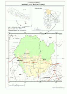
Sainamaina Municipality also known as Dudharakchhe is one of the new 72 municipalities formed in Nepal. It is located in Rupandehi District in the Lumbini Zone of southern Nepal. The Municipality was established on 18 May 2014 merging two existing VDCs i.e. Dudharakchhe and Parroha. At the time of the 2011 Nepal census it had a population of 48,178 people. Official website of Sainamaina Municipality is www.sainamainamunicipality.gov.np.
Khairahani is a municipality in Chitwan District in the Narayani Zone of southern Nepal. The municipality was established on 08 May 2014 by merging the existing Khairahani, Kumroj and Chainpur VDCs. At the time of the 1991 Nepal census it had a population of 13,629 people living in 2262 households.

Sundar Haraicha is a municipality in Morang District of Province No. 1 in Nepal that was established on 10 March 2017 by merging the former municipalities Sundar Dulari and Koshi Haraicha. At the time of the 2011 Nepal census, the localities out of which Chaudandigadhi would be formed had a joint population of 80,518 people living in 18,610 individual households.