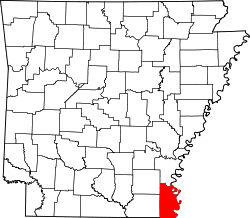
Bellaire, Arkansas | |
---|---|
Coordinates: 33°30′14.4″N91°21′32.4″W / 33.504000°N 91.359000°W | |
Country | United States |
State | Arkansas |
County | Chicot |
Elevation | 41 m (135 ft) |
Time zone | UTC-6 (Central (CST)) |
• Summer (DST) | UTC-5 (CDT) |
GNIS feature ID | 61706 |
U.S. Geological Survey Geographic Names Information System: Bellaire, Arkansas |
Bellaire is an unincorporated community in Chicot County, Arkansas, United States. It is located on U.S. Route 65. [1] [2]
Arkansas is a landlocked state in the south-central region of the Southern United States. It is bordered by Missouri to the north, Tennessee and Mississippi to the east, Louisiana to the south, and Texas and Oklahoma to the west. Its name is from the Osage language, a Dhegiha Siouan language, and referred to their relatives, the Quapaw people. The state's diverse geography ranges from the mountainous regions of the Ozark and Ouachita Mountains, which make up the U.S. Interior Highlands, to the densely forested land in the south known as the Arkansas Timberlands, to the eastern lowlands along the Mississippi River and the Arkansas Delta.
Chicot County is a county located in the southeastern corner of the U.S. state of Arkansas. As of the 2020 census, the population was 10,208. The county seat is Lake Village. Chicot County is Arkansas's 10th county, formed on October 25, 1823, and named after Point Chicot on the Mississippi River. It is part of the Arkansas Delta, lowlands along the river that have been historically important as an area for large-scale cotton cultivation.
Bellaire is a village in the U.S. state of Michigan. It is the county seat of Antrim County. The population was 1,053 in 2020 census.
Bellaire is a village in Belmont County, Ohio, United States, along the Ohio River. The population was 3,870 at the 2020 census, having had its peak in 1920. It is part of the Wheeling metropolitan area.
Bellaire is a city in southwest Harris County, Texas, United States, within the Houston–Sugar Land–Baytown metropolitan area. As of the 2020 U.S. census, the city population was 17,202. It is surrounded by the cities of Houston and West University Place. Bellaire is known as the "City of Homes", owing to its mostly residential character; but it has offices along the I-610 Loop within the city limits.
Southside Place is a city in west central Harris County, Texas, United States. The population was 1,835 at the 2020 census.
West University Place, often called West University or West U for short, is a city located in the U.S. state of Texas within the Houston–Sugar Land metropolitan area and southwestern Harris County. At the 2020 U.S. census, the population of the city was 14,955. It is nicknamed "The Neighborhood City" and is mainly a bedroom community for upper-class families.
Bellaire may refer to:
Chinatown is a community in Southwest Houston, Texas, United States.
Bellaire High School is a comprehensive, public secondary school in Bellaire, Texas. Part of the Houston Independent School District, it serves the incorporated city of Bellaire, the Houston community of Meyerland, and other adjacent Houston neighborhoods. It has a racially and socioeconomically diverse student body.
Willow Meadows is a subdivision in Houston, Texas, United States.
The Bellaire Bridge or Interstate Bridge is a privately owned, closed cantilever truss toll bridge that spans the Ohio River between Benwood, West Virginia and Bellaire, Ohio. It provided a link for commuters between southern Ohio border towns and West Virginia steel mills from 1926 to 1991.
Bellaire High School is a public high school located in Bellaire, Ohio, United States. It is the only high school in the Bellaire Local School District. Athletic teams compete as the Bellaire Big Reds in the Ohio High School Athletic Association as a member of the Buckeye 8 Athletic League as well as the Ohio Valley Athletic Conference.
Belmont Glass Company, also known as the Belmont Glass Works, was one of Ohio's early glassmaking companies. It was named after Belmont County, Ohio, where the plant was located. The firm began operations in 1866 in a riverfront village along the east side of the county, which is known as Bellaire. At that time, the community had resource advantages that made it an attractive site for glassmaking. Bellaire's location at the intersection of the Ohio River, the National Road, and two railroads meant it had an excellent transportation infrastructure. Fuel necessary for the glassmaking process was also readily available, since Belmont County was part of the eastern Ohio coal region. Bellaire also had a workforce with glassmaking expertise located less than five miles away, since glass had been produced in Wheeling, West Virginia, since the 1820s.
Henry Crimmel was an American glassmaker who became well known in Ohio and Indiana. A German that came with his family to America at the age of eight years, the American Civil War veteran started at the lowest level in glass making, and learned every aspect of the business. A skilled glassblower known for his glassmaking expertise and the recipient of two patents, he also worked in management in at least three glass factories – and was one of the co-founders of the Novelty Glass Company and the reorganized version of Sneath Glass Company. He retired with over 50 years in the industry.
Bellaire is an unincorporated community in Smith County, Kansas, United States. It was named after Bellaire, Ohio.
Bellaire is an unincorporated community in White Bear Township, Ramsey County, Minnesota, United States.
Robindell is a subdivision in Southwest Houston, Texas.
Bellaire–Puritas is a neighborhood on the West Side of Cleveland, Ohio, in the United States. Originally part of the Village of West Park, it was annexed by the city in 1923. Formerly known as Puritas–Longmead, the neighborhood takes its name from the two streets which form its northern boundary: Puritas Avenue and Bellaire Road.
Bellaire Gardens is an unincorporated community in Marion Township, Marion County, Ohio, United States. It is located north of Marion along Ohio State Route 4 at the northern end of the State Route 4/State Route 423 overlap, at 40°37′13″N83°07′56″W.