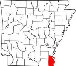
Bowman, Chicot County, Arkansas

Last updated

Bowman, Chicot County,
Arkansas
USA Arkansas location map.svg
Red pog.svg
Bowman
Usa edcp location map.svg
Red pog.svg
Bowman
Coordinates: 33°27′14″N91°18′11″W / 33.45389°N 91.30306°W / 33.45389; -91.30306
Country Flag of the United States.svg  United States
State Flag of Arkansas.svg  Arkansas
County Chicot
Elevation
72 m (236 ft)
Time zone UTC-6 (Central (CST))
  Summer (DST) UTC-5 (CDT)
GNIS feature ID57415
U.S. Geological Survey Geographic Names Information System: Bowman, Chicot County, Arkansas

Bowman is an unincorporated community in Chicot County, Arkansas, United States. [1]

Related Research Articles

<span class="mw-page-title-main">Chicot County, Arkansas</span> County in Arkansas, United States

Chicot County is a county located in the southeastern corner of the U.S. state of Arkansas. As of the 2020 census, the population was 10,208. The county seat is Lake Village. Chicot County is Arkansas's 10th county, formed on October 25, 1823, and named after Point Chicot on the Mississippi River. It is part of the Arkansas Delta, lowlands along the river that have been historically important as an area for large-scale cotton cultivation.

<span class="mw-page-title-main">Lake Village, Arkansas</span> City in Arkansas, United States

Lake Village is a city in and the county seat of Chicot County, Arkansas, United States. The population was 2,575 at the 2010 census. It is located in the Arkansas Delta. Lake Village is named for its location on Lake Chicot, an oxbow lake formed by the Mississippi River.

Bowman may refer to:

<span class="mw-page-title-main">Lake Chicot</span> Lake in Arkansas, United States

Lake Chicot is a lake adjacent to the Mississippi River. The lake is located on the east side of Lake Village, Arkansas in Chicot County. It is not only the largest oxbow lake in North America, but the largest natural lake in Arkansas, formed 300 years ago by the meandering of the Mississippi River.

<span class="mw-page-title-main">South Arkansas</span> Region in Arkansas, United States

South Arkansas lies within the southernmost portions of Arkansas Gulf Coastal Plain and Delta regions. It encompasses the lower 15 counties of the state.

<span class="mw-page-title-main">Lake Chicot State Park</span> State park in Arkansas, United States

Lake Chicot State Park is a 211.6 acres (85.6 ha) Arkansas state park in Chicot County, Arkansas within the Arkansas delta. The park is located along Lake Chicot, a 22 miles (35 km) oxbow lake that was formerly the main channel of the Mississippi River. The lake, formerly a polluted eyesore for the area, has been restored to its current condition through the cooperation of many agencies to return its natural, cultural and recreational value. As the state's largest natural lake and the largest oxbow lake in the United States, Lake Chicot State Park features unique fishing and camping opportunities among large cypress trees, creating a bayou environment for both wildlife and visitors.

<span class="mw-page-title-main">Arkansas Highway 2</span> Former state highway in Arkansas

State Road 2 is a former east–west state highway in the Arkansas Timberlands and Lower Arkansas Delta. The route was approximately 195 miles (314 km), and ran from US Route 67 (US 67) in Texarkana east to cross the Mississippi River near Lake Village, continuing as Mississippi Highway 10. On July 1, 1931, the route was entirely replaced by US Highway 82 (US 82) by the American Association of State Highway Officials (AASHTO). The route was maintained by the Arkansas Highway Department (AHD), now known as the Arkansas Department of Transportation (ArDOT).

<span class="mw-page-title-main">National Register of Historic Places listings in Chicot County, Arkansas</span>

This is a list of the National Register of Historic Places listings in Chicot County, Arkansas.

<span class="mw-page-title-main">Arkansas Highway 142</span> Highway in Arkansas

Highway 142 is a north–south state highway in Chicot County, Arkansas. The route starts its southern terminus at Levee Road near Lakeport. The road then travels north, passing through the Lakeport Plantation. It ends at its northern terminus at U.S. Route 82 and US 278 in Shives. AR 142 was designated in 1931, from US 61 to the Mississippi River, and part of the route was redesignated as part of US 82 in 1940. The route was paved in asphalt by 1962. The route is maintained by the Arkansas Department of Transportation (ArDOT).

Bowman, Arkansas may refer to:

<span class="mw-page-title-main">Arkansas Highway 35</span>

Arkansas Highway 35 is a northwest–southeast state highway in southeast Arkansas. The route runs 115.83 miles (186.41 km) from Dewey near the Mississippi River northwest to Arkansas Highway 5 in Benton.

Yellow Bayou is an unincorporated community in Chicot County, Arkansas, United States. Yellow Bayou is located on the west bank of Connerly Bayou, 5.5 miles (8.9 km) north-northeast of Lake Village.

Luna is an unincorporated community in eastern Chicot County, Arkansas, United States. The community sits between the Mississippi River to the northeast and Lake Chicot to the southwest. Lake Chicot State Park lies to the south. Luna is located on Arkansas Highway 144, 5.75 miles (9.25 km) northeast of Lake Village.

Chanticleer is an unincorporated community in Chicot County, Arkansas, United States. It is located at the junction of U.S. Routes 65 and 82, and Arkansas Highway 159 at the southern border of Lake Village.

<span class="mw-page-title-main">Lakeside School District (Lake Village, Arkansas)</span> School district in Arkansas

Lakeside School District is a public school district based in Lake Village, Arkansas, United States. The Lakeside School District encompasses 242.54 square miles (628.2 km2) of land including all or portions of Chicot County and Ashley County communities. Incorporated places within the district include Lake Village in Chicot County, and Montrose in Ashley County. It also serves the Chicot County unincorporated area of Ross Van Ness.

<span class="mw-page-title-main">Chicot County Courthouse</span> United States historic place

The Chicot County Courthouse is a courthouse in Lake Village, Arkansas, the county seat of Chicot County, built in 1956. Located at the end of the Lake Village Commercial Historic District along Lake Chicot, the courthouse is a culturally significant landmark for both its architectural style and historical importance to the county. It was because of this dual significance that the property was listed on the National Register of Historic Places in 2006.

Grand Lake is an unincorporated community in Chicot County in the U.S. state of Arkansas.

Eudora School District was a school district based in Eudora, Arkansas. Its schools were G. C. Johns Lower Elementary School, G. C. Johns Upper Elementary School, and Eudora High School.

<span class="mw-page-title-main">Arkansas Highway 144</span>

Highway 144 is a designation for two state highways in Southeast Arkansas. One route of 7.82 miles (12.59 km) begins at Big Bayou Meto Use Area and runs east to US Highway 165 (US 165), Highway 1, and the Great River Road (GRR). A second route of 20.50 miles (32.99 km) begins at US 165 near Jerome and runs east through Lake Village to a levee near the Mississippi River. Both routes are maintained by the Arkansas Department of Transportation (ArDOT). While overlapping US 65/US 278 in Chicot County, the route is part of the Great River Road, a national scenic byway following the Mississippi River.

<span class="mw-page-title-main">Green Hill Jones</span> American politician

Green Hill Jones was a state legislator and Baptist minister in Arkansas. He served in the Arkansas House of Representatives for Chicot County in 1885 and 1889, and he was a Republican.

References

  1. "Feature Detail Report for: Bowman, Arkansas." USGS. U.S. Geological Survey Geographic Names Information System: Bowman, Chicot County, Arkansas Retrieved May 2, 2011.