Belpahari

Last updated

Belpahari
Village
West Bengal location map.svg
Red pog.svg
Belpahari
Location in West Bengal, India
India location map.svg
Red pog.svg
Belpahari
Belpahari (India)
Coordinates: 22°37′59″N86°45′53″E / 22.6331°N 86.7646°E / 22.6331; 86.7646
CountryFlag of India.svg  India
State West Bengal
District Jhargram
Subdivision Jhargram
Languages
  Official Bengali, Santali, Kudmali/Kurmali, English
Time zone UTC+5:30 (IST)
ISO 3166 code IN-WB
Vehicle registration WB-49/WB-50
Website jhargram.gov.in

Belpahari is a village in the Binpur II CD block in the Jhargram subdivision of the Jhargram district in West Bengal, India.

Contents

It had been in the frontline frequently for the killings of Communist Party of India (Marxist) leaders and supporters repeatedly by the Communist Party of India (Maoist) guerrillas.

Geography

Belpahari
Cities and towns in Jhargram subdivision of Jhargram district
CT: census town, R: rural/ urban centre, H: historical/ religious centre
Owing to space constraints in the small map, the actual locations in a larger map may vary slightly

Location

Belpahari is located in 22°37′59″N86°45′53″E / 22.6331°N 86.7646°E / 22.6331; 86.7646 .

Area overview

Jhargram subdivision, the only one in Jhargram district, shown in the map alongside, is composed of hills, mounds and rolling lands. It is rather succinctly described in the District Human Development Report, 2011 (at that time it was part of Paschim Medinipur district), “The western boundary is more broken and picturesque, for the lower ranges of the Chhotanagpur Hills line the horizon, the jungle assumes the character of forest, and large trees begin to predominate. The soil, however, is lateritic, a considerable area is unproductive, almost uninhabited, especially in the extreme north-west where there are several hills over 1000 feet in height. The remainder of the country is an almost level plain broken only by the sand hills.” [1] 3.48% of the population lives in urban areas and 96.52% lives in the rural areas. 20.11% of the total population belonged to scheduled castes and 29.37% belonged to scheduled tribes. [2]

Note: The map alongside presents some of the notable locations in the subdivision. All places marked in the map are linked in the larger full screen map.

Demographics

As per 2011 Census of India Belpahari had a total population of 1,863 of which 908 (49%) were males and 955 (51%) were females. Population below 6 years was 224. The total number of literates in Belpahari was 1,245 (76% of the population over 6 years). [3]

Civic administration

CD block HQ

The headquarters of Binpur II CD block are located at Belpahari. [4]

Police station

Belpahari police station has jurisdiction over a part of Binpur II CD block. [5] [6]

Transport

State Highway 5 (West Bengal) running from Rupnarayanpur (in Bardhaman district) to Junput (in Purba Medinipur district) passes through Belpahari. [7]

Healthcare

Belpahari Rural Hospital, with 30 beds at Belpahari, is the major government medical facility in the Binpur II CD block. [8]

See also

Related Research Articles

<span class="mw-page-title-main">Nayagram (community development block)</span> Community development block in West Bengal, India

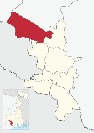
Nayagram is a community development block that forms an administrative division in Jhargram subdivision of Jhargram district in the Indian state of West Bengal.

<span class="mw-page-title-main">Lalgarh, Jhargram</span> Census Town in West Bengal, India

Lalgarh is a small town and a gram panchayat in the Binpur I CD block under the Jhargram subdivision of the Jhargram district in the Indian state of West Bengal.

<span class="mw-page-title-main">Jhargram subdivision</span> Subdivision in West Bengal, India

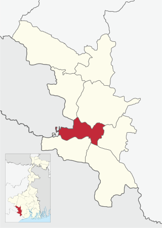
Jhargram Sadar Subdivision is an administrative Subdivision of the Jhargram district in the state of West Bengal, India. It became part of the Jhargram district from 4 April 2017 after splitting from the Paschim Medinipur district.

<span class="mw-page-title-main">Binpur I</span> Community development block in West Bengal, India

Binpur I is a community development block that forms an administrative division in Jhargram subdivision of Jhargram district in the Indian state of West Bengal.

Binpur is a village in the Binpur I CD block in the Jhargram subdivision of the Jhargram district in the state of West Bengal, India.

<span class="mw-page-title-main">Binpur II</span> Community development block in West Bengal, India

Binpur II is a community development block that forms an administrative division in Jhargram subdivision of Jhargram district in the Indian state of West Bengal.

<span class="mw-page-title-main">Jamboni (community development block)</span> Community development block in West Bengal, India

Jamboni is a community development block that forms an administrative division in Jhargram subdivision of Jhargram district in the Indian state of West Bengal.

<span class="mw-page-title-main">Jhargram (community development block)</span> Community development block in West Bengal, India

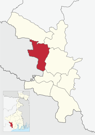
Jhargram is a community development block that forms an administrative division in Jhargram subdivision of Jhargram district in the Indian state of West Bengal.

<span class="mw-page-title-main">Gopiballavpur II</span> Community development block in West Bengal, India

Gopiballavpur II is a community development block that forms an administrative division in Jhargram subdivision of Jhargram district in the Indian state of West Bengal.

Silda is a census town in the Binpur II CD block in the Jhargram subdivision of the Jhargram district in the Indian state of West Bengal.

Chhatinasol is a village in the Gopiballavpur I CD block in the Jhargram subdivision of the Jhargram district in the state of West Bengal, India.

Beliaberah is a village in the Gopiballavpur II CD block in the Jhargram subdivision of the Jhargram district in the state of West Bengal, India.

Jamboni is a village and a gram panchayat in the Jamboni CD block in the Jhargram subdivision of the Jhargram district in the state of West Bengal, India.

Gidhni is a village in the Jamboni CD block in the Jhargram subdivision of the Jhargram district in the state of West Bengal, India.

<span class="mw-page-title-main">Chilkigarh</span> Village in West Bengal, India

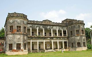
Chilkigarh is a village and a gram panchayat in Jamboni CD block in the Jhargram subdivision of the Jhargram district in the state of West Bengal, India.

Dahijuri is a village and a gram panchayat in the Binpur I CD block in the Jhargram subdivision of the Jhargram district in the state of West Bengal, India.

Sijua is a village and a gram panchayat in the Binpur I CD block in the Jhargram subdivision of the Jhargram district in the state of West Bengal, India.

Netai is a village in the Binpur I CD block in the Jhargram subdivision of the Jhargram district in the state of West Bengal, India.

Ergoda is a village and a gram panchayat in the Binpur II CD block in the Jhargram subdivision of the Jhargram district in the state of West Bengal, India.

Tapsia is a village in the Gopiballavpur II CD block in the Jhargram subdivision of the Jhargram district in the state of West Bengal, India.

References

  1. "District Human Development Report Paschim Medinipur, 2011". pages 4-5. Department of Planning and Statistics, Government of West Bengal. Retrieved 10 September 2020.
  2. "District Statistical Handbook Paschim Medinipur, 2013". Table 2.2, 2.4 (a). Department of Planning and Statistics. Retrieved 10 September 2020.
  3. "2011 Census – Primary Census Abstract Data Tables". West Bengal – District-wise. Registrar General and Census Commissioner, India. Retrieved 15 September 2016.
  4. "District Census Handbook: Paschim Medinipur" (PDF). Map of Paschim Medinipur with CD Block HQs and Police Stations (on the fifth page). Directorate of Census Operations, West Bengal, 2011. Retrieved 20 November 2016.
  5. "District Statistical Handbook 2014 Paschim Medinipur". Tables 2.1, 2.2. Department of Planning and Statistics, Government of West Bengal. Retrieved 14 September 2020.
  6. "District at a Glance". Paschim Medinipur District Police. Archived from the original on 27 October 2016. Retrieved 27 October 2016.
  7. "List of State Highways in West Bengal". West Bengal Traffic Police. Retrieved 22 September 2016.
  8. "Health & Family Welfare Department" (PDF). Health Statistics – Rural Hospitals. Government of West Bengal. Archived from the original (PDF) on 8 October 2022. Retrieved 1 September 2020.