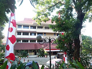
Cempaka Putih is a district in the administrative city of Central Jakarta. Cempaka Putih is bounded by Jenderal Ahmad Yani Bypass Highway to the east, Pramuka Road to the south, Letjend Suprapto Road to the north, and a railway line to the west. The name "Cempaka Putih" is derived from flowering plant white champaca.

Senen is a long-established urban district of Central Jakarta, Indonesia that has kept many tourist attractions such as two museums, the National Library of Indonesia, Gelanggang Remaja Senen, and narrow alleys with old Chinese and similar style shops and restaurants. It was first developed in the 18th-century as Pasar Senen when governor Daendels established the bovenstad as the new center of government of the fledgling city. Its core remains in what is now the lower-division subdistrict of Senen, Kwitang, Kenari, Paseban, Kramat, and Bungur. Senen is bounded by a railway line to the east, Ciliwung River to the west, Pramuka Street to the south, and Abdul Rahman Saleh-Kwini II-Senen Raya IV street to the north. The name is derived from Pasar Senen,.
Grogol is an urban administrative village in the Grogol Petamburan subdistrict of West Jakarta, Indonesia. The triangle-shaped administrative village is bounded by the West Flood Canal to the east, Jakarta Inner Ring Road to the west, and Jalan Kyai Tapa to the south. It was among the first Jakarta's planned suburb established during the 1960s.

Setiabudi is a district in the administrative city of South Jakarta, Indonesia. It is part of the Golden Triangle of Jakarta, the centre of business and commercial establishments in the city. Setiabudi is named after an Indonesian hero of partial Indo and Sundanese descent, Ernest Douwes Dekker, also known as Danudirdja Setiabudi. Setiabudi is bordered by Central Jakarta in the north.

Kebayoran Baru is a district in the administrative city of South Jakarta, Indonesia. The name was derived from a planned satellite city of the same name which was developed in the post-war period. Kebayoran Baru was the last residential area to be developed by the Dutch colonial administration. The urban planning was laid in a concept of the Garden city movement, consisting of a well-planned residential area, a shopping center, and a business district, supported with civic facilities such as schools, places of worship, hospitals, and parks. Today, the district is home to many important government institutions, such as the Indonesia Stock Exchange building, the ASEAN Headquarters building, the National Police headquarters, and the City Hall of South Jakarta. Sudirman Central Business District is also located in the district.
Tebet is a district in the administrative city of South Jakarta, Indonesia. The boundaries of Tebet are Jend. Gatot Subroto-Letjen Haryono MT. tollway to the south, Ciliwung River to the east, Jalan Casablanca - Ciliwung River to the north, and Cideng River to the west. This district is home to SMA Negeri 8 Jakarta
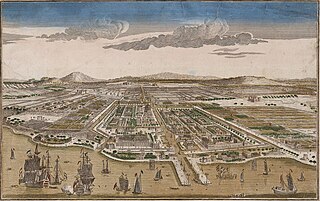
Jakarta is Indonesia's capital and largest city. Located on an estuary of the Ciliwung River, on the northwestern part of Java, the area has long sustained human settlement. Historical evidence from Jakarta dates back to the 4th century CE, when it was a Hindu settlement and port. The city has been sequentially claimed by the Indianized kingdom of Tarumanegara, the Hindu Kingdom of Sunda, the Muslim Sultanate of Banten, and by Dutch, Japanese and Indonesian administrations. The Dutch East Indies built up the area before it was taken during World War II by the Empire of Japan and finally became independent as part of Indonesia.
Jakarta Inner Ring Road, also known as the Jakarta Inner-City Toll Road is a toll road circling the city of Jakarta, Indonesia. On northern and the eastern section, the toll road is grade-separated with the Sosrobahu road construction technique. The toll road is operated by PT Jasa Marga (Persero) Tbk, a state-owned enterprise, and PT Citra Marga Nushapala Persada Tbk (CMNP), founded by the Suharto family which is also the initiator of the Metro Manila Skyway.
Senayan is an administrative village at Kebayoran Baru subdistrict, South Jakarta, Indonesia. The post code is 12190.
Tanah Tinggi is an administrative village in the Johar Baru district of Indonesia. It has a postal code of 10540.
Petamburan is an administrative village in the Tanah Abang district of Indonesia. It has postal code of 10260. The area is 0.90 km2. The population is 32,946 as of 2019. There are 16,900 males and 16,046 females.

Jalan M.H. Thamrin or Jalan Thamrin is a major thoroughfare in Jakarta, Indonesia. The road is located at the center of Jakarta, running from the north end of Jalan Jenderal Sudirman at West Flood Canal at the south end to the roundabout near Arjuna Wijaya Statue Jakarta at the north end. Developed in the 1950s, the road was a landmark of post-colonial Indonesia and continues to have a prominent importance in Jakarta.

Jalan Jenderal Sudirman or Jalan Sudirman is a major thoroughfare in Jakarta, Indonesia. Named after Indonesian national hero Sudirman, the road runs from Patung Pemuda Membangun at the south end to the bridge of the West Flood Canal to the north, where it meets Jalan M.H. Thamrin. The road had been built between 1949 and 1953 to connect Central Jakarta with Kebayoran Baru.
Pejompongan is a residential area located northeast of Gelora Bung Karno Sports Complex, and in the south area of Slipi in Jakarta, Indonesia. This area was built as residential area for upper middle-class government employees and employees of other state institutions since 1950s. Pejompongan region Administratively located in the District of Tanah Abang and mostly located in the Village of Bendungan Hilir.

Palmerah Station (PLM) is a railway station located in Jalan Tentara Pelajar, Gelora, Tanah Abang, Central Jakarta, near the Palmerah market. The station is located in the altitude of +13 meters above sea level, and only serves KRL Commuterline's Rangkasbitung Line.

Jalan Jenderal Gatot Subroto(Gatot Subroto Avenue) is one of the major roads in Jakarta, Indonesia. The road starts from Dirgantara statue in South Jakarta, which crosses 10 administrative villages and ends at Slipi, Central Jakarta. The road is named after National Hero of Indonesia General Gatot Subroto. The road was constructed in 1960s. The road runs parallel with Jakarta Inner Ring Road. The location of the road is within the Golden Triangle CBD of Jakarta. Many important office buildings and skyscrapers are situated along the road.
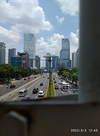
The Golden Triangle of Jakarta or can also be referred to as Medan Merdeka–Thamrin–Sudirman Axis or Sudirman–Thamrin–Kuningan Axis, is a roughly triangular area in the center of Jakarta, Indonesia, extending from Central Jakarta to South Jakarta. Most of the city's foreign embassies and tallest skyscrapers are located in the area, which is the main CBD of Jakarta.

Bendungan Hilir Station is a rapid transit station on the North-South Line of the Jakarta MRT. It is located at Jalan Jenderal Sudirman, at the border between Karet Tengsin, Tanah Abang in Central Jakarta and Karet Semanggi, Setiabudi in South Jakarta, and has the station code BNH.

The TransJakarta Corridor 9 is the TransJakarta bus rapid transit corridor that operates from the Pinang Ranti bus terminal in East Jakarta to the Pluit BRT station in North Jakarta. The streets traversed by corridor 9 are Jalan Pluit Putri/Putra, Jalan Jembatan Tiga, Jalan Prof Dr. Latumeten, Jalan Satria/Prof. Dr. Makaliwe, Jalan Letjen S. Parman, Jalan Jend. Gatot Subroto, Jalan MT Haryono, Jalan Mayjen Sutoyo, Jagorawi Toll Road, and Jalan Pondok Gede Raya. Corridor 9 is integrated with the KAI Commuter Bogor Line service at the Cikoko Stasiun Cawang BRT station that connects to the Cawang railway station and the Tangerang Line at the Latumeten Stasiun Grogol BRT station that connects to the Grogol railway station on Jalan Satria/Prof. Dr. Makaliwe. Corridor 9 is also integrated with Jabodebek LRT from BNN to Pancoran Barat BRT stations.
