Related Research Articles
Tanah Abang is a district of Central Jakarta, Indonesia. The district hosts the biggest textile market in Southeast Asia, Tanah Abang Market. It hosts Bung Karno Stadium, in Kelurahan Gelora, and the western half of the largely skyscraper-dominated Sudirman Central Business District.
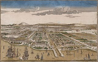
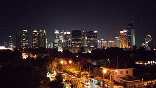
Jakarta is Indonesia's capital and largest city. Located on an estuary of the Ciliwung River, on the northwestern part of Java, the area has long sustained human settlement. Historical evidence from Jakarta dates back to the 4th century CE, when it was a Hindu settlement and port. The city has been sequentially claimed by the Indianized kingdom of Tarumanegara, the Hindu Kingdom of Sunda, the Muslim Sultanate of Banten, and by Dutch, Japanese and Indonesian administrations. The Dutch East Indies built up the area before it was taken during World War II by the Empire of Japan and finally became independent as part of Indonesia.
Senayan is an administrative village at Kebayoran Baru subdistrict, South Jakarta, Indonesia. The post code is 12190.

Bendungan Hilir is an administrative village in the Tanah Abang district of Indonesia. It has a population of 20,025 people.

Manggarai Station (MRI) is a railway station at Manggarai, Tebet, South Jakarta, Jakarta, Indonesia. At present, it serves primarily as a transit station for KRL Commuterline's Bogor Line and Cikarang Loop Line, as well as Soekarno–Hatta Airport Rail Link; The Bukit Duri depot is located in south of the station. It is also serves as a storage for intercity trains before they goes to Gambir or Jakarta Kota stations for their departure.
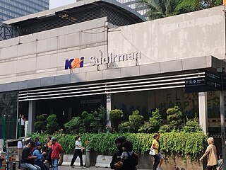
Sudirman Station is a train station of KRL Commuterline, which is located in Menteng, Central Jakarta, Indonesia. The station is named from Jalan Jenderal Sudirman, one of the main avenue in Jakarta, which crosses above the station. This station is located on the north bank of West Flood Canal. Though this station serves only Commuterline trains, but it is a transit point for other types of public transportation as part of the Dukuh Atas TOD.

The Jakarta Flood Canal refers to two canals that divert floods from rivers around Jakarta instead of going through the city. This first flood control channel was designed by Hendrik van Breen, an engineer working for the Dutch East Indian Department van Burgelijke Openbare Werken, after a big flood hit the city on 13 February 1918.

Tanah Abang Station (THB) is a railway station located in Kampung Bali, Tanah Abang, Central Jakarta, Jakarta, Indonesia. The station located to the east of West Flood Canal, and serves Rangkasbitung and Cikarang Loop lines of KRL Commuterline. The station and the canal are only separated by a small, narrow embankment and as such, Tanah Abang station is prone to flooding, especially during the heavy rain season.

Duri Station (DU) is a railway station located in West Jakarta. It serves as the starting point and the eastern terminus of the Tangerang Line service. The station is a major transfer point for commuters to or from Tangerang. When the Jakarta Kota-Manggarai railway is disrupted, trains between Jakarta Kota and Manggarai are rerouted via Duri.
Parung Panjang Station is a railway station that is located in Parung Panjang, Bogor Regency, Indonesia. During the colonial era, this station was important due to the location that is midway between Merak Station and Jakarta Kota Station. Before, the station was the last station that has been upgraded to receive an electrified train. But now, the last station changed to Rangkasbitung Station. The station is located in front of Parung Panjang Market. The road in front of the station is a road from Curug, many commuter from Curug uses this station to go to Jakarta.

Maja Station (MJ) is a class II railway station located in Maja, Maja, Lebak Regency. This station is included in the Operation Area I Jakarta.

Rangkasbitung Station (RK) is a railway station located in East Muara Ciujung, Rangkasbitung, Lebak Regency, Banten.

The KA Commuter line Tanah Abang–Rangkasbitung or the Rangkasbitung line is a commuter rail line in Indonesia, operated by PT Kereta Commuter Indonesia (KCI). The line connects Tanah Abang station in Central Jakarta and Rangkasbitung station in Lebak Regency, Banten. On maps and diagrams, the line is shown using the color "green". Tanah Abang–Rangkasbitung line is the longest and fourth busiest line in the KRL Commuterline system.

Palmerah Station (PLM) is a railway station located in Jalan Tentara Pelajar, Gelora, Tanah Abang, Central Jakarta, near the Palmerah market. The station is located in the altitude of +13 meters above sea level, and only serves KRL Commuterline's Rangkasbitung Line.

Jurangmangu Station (JMG) is a class III railway station located in Sawah Lama, Ciputat, South Tangerang. The station is located at the elevation of +25 metres above sea level, is included in the Operation Area I Jakarta. Even though it is called Jurangmangu, this station is not located in Jurangmangu Village, Pondok Aren District, but is located in the south of Jurangmangu village itself.

Jalan Jenderal Gatot Subroto(Gatot Subroto Avenue) is one of the major roads in Jakarta, Indonesia. The road starts from Dirgantara statue in South Jakarta, which crosses 10 administrative villages and ends at Slipi, Central Jakarta. The road is named after National Hero of Indonesia General Gatot Subroto. The road was constructed in 1960s. The road runs parallel with Jakarta Inner Ring Road. The location of the road is within the Golden Triangle CBD of Jakarta. Many important office buildings and skyscrapers are situated along the road.

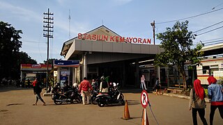
Kemayoran Station (KMO) is a railway station located at South Gunung Sahari, Kemayoran, Central Jakarta, Indonesia. This station is located between Pasar Senen railway station in the south and Rajawali railway station in the north. The station is a stoppage for Jakarta metro commuter rail.

Tigaraksa Station (TGS) is a large class type C railway station located in Cikasungka, Solear, Tangerang Regency. The station, which is located at an altitude of +51 meters, is included in the Operation Area I Jakarta. Even though it is named Tigaraksa, this station is not located in the Tigaraksa district, but is located in the south of the Tigaraksa district itself.
Rawa Buntu Station (RU) is a class III railway station located in Rawa Buntu, Serpong, South Tangerang. This station is included in the Operational Area I Jakarta, and is located adjacent to the planned city complex Bumi Serpong Damai (BSD). This station is not far from the Serpong exit on the west Jakarta–Serpong Toll Road. In addition, the station is strategically located because it is close to a residential complex in the Serpong area.
References
- ↑ Freek Colombijn; Joost Coté (2014). Cars, Conduits, and Kampongs: The Modernization of the Indonesian City, 1920-1960, Verhandelingen van het Koninklijk Instituut voor Taal-, Land- en Volkenkunde. BRILL. ISBN 978-90-04-28072-4.
- ↑ "Sejarah Daerah Pejompongan" (in Indonesian). Retrieved December 20, 2016.