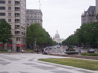
Pennsylvania Avenue is a diagonal street in Washington, D.C. and Prince George's County, Maryland that connects the White House and the United States Capitol and then crosses the city to Maryland. In Maryland it is also Maryland Route 4 to MD-717 where it becomes Stephanie Roper Highway. The section between the White House and Congress is called "America's Main Street"; it is the location of official parades and processions, as well as protest marches. Moreover, Pennsylvania Avenue is an important commuter road and is part of the National Highway System.

Dupont Circle is a traffic circle, park, neighborhood, and historic district in Northwest Washington, D.C.. The Dupont Circle neighborhood is bounded approximately by 16th Street NW to the east, 22nd Street NW to the west, M Street NW to the south, and Florida Avenue NW to the north. Much of the neighborhood is listed on the National Register of Historic Places. However, the local government Advisory Neighborhood Commission and the Dupont Circle Historic District have slightly different boundaries.
Constitution Avenue is a major east-west street in the northwest and northeast quadrants of the city of Washington, D.C., in the United States. It was originally known as B Street, and its western section was greatly lengthened and widened between 1925 and 1933. It received its current name on February 26, 1931. Constitution Avenue's western half defines the northern border of the National Mall and extends from the United States Capitol to the Theodore Roosevelt Bridge. Its eastern half runs through the neighborhoods of Capitol Hill and Kingman Park before it terminates at Robert F. Kennedy Memorial Stadium. A large number of federal departmental headquarters, memorials, and museums line Constitution Avenue's western segment.

There are many outdoor sculptures in Washington, D.C. In addition to the capital's most famous monuments and memorials, many figures recognized as national heroes have been posthumously awarded with his or her own statue in a park or public square. Some figures appear on several statues: Abraham Lincoln, for example, has at least three likenesses, including those at the Lincoln Memorial, in Lincoln Park, and the old Superior Court of the District of Columbia. A number of international figures, such as Mohandas Gandhi, have also been immortalized with statues. The Statue of Freedom is a 19½-foot tall allegorical statue that rests atop the United States Capitol dome.

Freedom Plaza, originally known as Western Plaza, is an open plaza in Northwest Washington, D.C., United States, located at the corner of 14th Street and Pennsylvania Avenue NW, adjacent to Pershing Park. The John A. Wilson Building, the seat of the District of Columbia government, faces the plaza, as does the historic National Theatre, which has been visited by every U.S. President since it opened in 1835. Three large hotels are to the north and west. The National Park Service administers the Plaza as part of its Pennsylvania Avenue National Historic Site and coordinates the Plaza's activities.

Independence Avenue is a major east-west street in the southwest and southeast quadrants of the city of Washington, D.C., in the United States, running just south of the United States Capitol. Originally named South B Street, Independence Avenue SW was constructed between 1791 and 1823. Independence Avenue SE was constructed in pieces as residential development occurred east of the United States Capitol and east of the Anacostia River. Independence Avenue SW received its current name after Congress renamed the street in legislation approved on April 13, 1934. Independence Avenue SW originally had its western terminus at 14th Street SW, but was extended west to Ohio Drive SW between 1941 and 1942. The government of the District of Columbia renamed the portion of the road in the southeast quadrant of the city in 1950.
Pennsylvania Avenue National Historic Site is a National Historic Site in the city of Washington, D.C. Established on September 30, 1965, the site is roughly bounded by Constitution Avenue, 15th Street NW, F Street NW, and 3rd Street NW. The historic district includes a number of culturally, aesthetically, and historically significant structures and places, including Pennsylvania Avenue NW from the White House to the United States Capitol, the Treasury Building, Freedom Plaza, Federal Triangle, Ford's Theatre, the Old Patent Office Building, the Old Pension Office Building, Judiciary Square, and the Peace Monument.

National Mall and Memorial Parks is an administrative unit of the National Park Service (NPS) encompassing many national memorials and other areas in Washington, D.C. Federally owned and administered parks in the capital area date back to 1790, some of the oldest in the United States. In 1933, they were transferred to the control of the National Park Service. These parks were known as the National Capital Parks from their inception until 1965. The NPS now operates multiple park groupings in the D.C. area, including National Capital Parks-East, Rock Creek Park, President's Park, and George Washington Memorial Parkway. National Mall and Memorial Parks also provides technical assistance for the United States Navy Memorial.

Ohio Drive is a street in Southwest Washington, D.C., located in East and West Potomac Parks and bordering the Tidal Basin, Washington Channel, and the Potomac River. It is a central organizing feature of East Potomac Park, providing the only major vehicular route to and through the area. Unlike most roadways named after states in the District of Columbia, Ohio Drive is not an avenue, nor it is heavily used like Wisconsin or Rhode Island Avenues. However, the segment from Independence Avenue to the Rock Creek and Potomac Parkway is an important commuter route.
Benjamin Franklin (1706–1790) was an American statesman, writer, scientist, inventor and printer.

Downtown is a neighborhood of Washington, D.C., as well as a colloquial name for the central business district in the northwest quadrant of the city. Geographically, the area extends roughly five to six blocks west, northwest, north, northeast, and east of the White House. Several important museums, theaters, and a major sports venue are located in the area. A portion of this area is known as the Downtown Historic District and was listed on the NRHP in 2001.

The Franklin School is a building designed by Adolf Cluss, located on Franklin Square at 13th and K Street in Washington, DC.

Franklin Square is a square in downtown Washington, D.C. Purportedly named after Benjamin Franklin, it is bounded by K Street NW to the north, 13th Street NW on the east, I Street NW on the south, and 14th Street NW on the west. It is served by the McPherson Square station of the Washington Metro, which is located just southwest of the park.

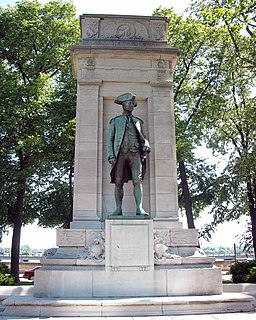
The statue of John Aaron Rawlins, a United States Army general who served during the Civil War and later as Secretary of War, is a focal point of Rawlins Park, a small public park in Washington, D.C.'s Foggy Bottom neighborhood. It was installed in 1874, but relocated several times between 1880 and 1931. The statue was sculpted by French-American artist Joseph A. Bailly, whose best known work is the statue of George Washington in front of Independence Hall in Philadelphia.
American Revolution Statuary is a group of fourteen statues in Washington, D.C., listed with the National Register of Historic Places. The statues are scattered across Washington, mainly in squares and traffic circles, with four statues of European officers displayed in Lafayette Square, across from the White House

The Stephenson Grand Army of the Republic Memorial, also known as Dr. Benjamin F. Stephenson, is a public artwork in Washington, D.C. honoring Dr. Benjamin F. Stephenson, founder of the Grand Army of the Republic, a fraternal organization for Union veterans. The memorial is sited at Indiana Plaza, located at the intersection of 7th Street, Indiana Avenue, and Pennsylvania Avenue NW in the Penn Quarter neighborhood. The bronze figures were sculpted by J. Massey Rhind, a prominent 20th century artist. Attendees at the 1909 dedication ceremony included President William Howard Taft, Senator William Warner, and hundreds of Union veterans.

The W Washington, D.C. is a historic hotel located at 515 15th Street NW in downtown Washington, D.C. It opened in 1918 as the Hotel Washington. It is operated by W Hotels.

Western Avenue is one of three boundary streets between Washington, D.C., and the state of Maryland. It follows a southwest-to-northeast line, beginning at Westmoreland Circle in the south and ending at Oregon Avenue NW in the north. It is roughly 3.5 miles (5.6 km) in length. First proposed in 1893, it was constructed somewhat fitfully from about 1900 to 1931.