
The Palatinate is a historical region of Germany (Deutschland). In the Middle Ages it was known as the Rhenish Palatinate (Rheinpfalz) and Lower Palatinate (Unterpfalz), which strictly speaking designated only the western part of the Electorate of the Palatinate, as opposed to the Upper Palatinate (Oberpfalz). It occupies roughly the southernmost quarter of the German federal state of Rhineland-Palatinate (Rheinland-Pfalz), covering an area of 2,105 square miles (5,450 km2) with about 1.4 million inhabitants. Its residents are known as Palatines (Pfälzer).
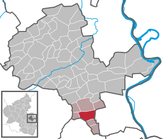
The Donnersbergkreis is a district (Kreis) in the middle of Rhineland-Palatinate, Germany. Neighboring districts are Bad Kreuznach, Alzey-Worms, Bad Dürkheim, Kaiserslautern, Kusel.
Kaiserslautern is a district (Kreis) in the south of Rhineland-Palatinate, Germany. Neighboring districts are Kusel, Saarpfalz-Kreis, Donnersbergkreis, Bad Dürkheim and Südwestpfalz. The city of Kaiserslautern is almost fully enclosed by, but not belonging to the district.
Kirchheimbolanden, the capital of Donnersbergkreis, is a town in Rhineland-Palatinate, south-western Germany. It is situated approximately 25 km west of Worms, and 30 km north-east of Kaiserslautern. The first part of the name, Kirchheim, dates back to 774. It became a town in 1368, and the Sponheim family improved its security with many towers and walls. William, Duke of Nassau, ancestor of the royal families of Belgium, Sweden, Denmark and Norway, and of the grand-ducal family of Luxembourg, was born in Kirchheimbolanden. It was also ruled by the First French Empire between 1792 and 1814, before passing to the Kingdom of Bavaria in 1815. It was a rural district centre in the Rheinkreis, which was renamed Pfalz (Palatinate) in 1835.

Kirchheimbolanden is an administrative unit (Verbandsgemeinde) in the German state of Rhineland-Palatinate.
Monsheim is an Ortsgemeinde – a municipality belonging to a Verbandsgemeinde, a kind of collective municipality – in the Alzey-Worms district in Rhineland-Palatinate, Germany.

Rockenhausen is a town in the Donnersbergkreis, in Rhineland-Palatinate, Germany. It is situated on the river Alsenz, approx. 30 km (19 mi) north of Kaiserslautern.

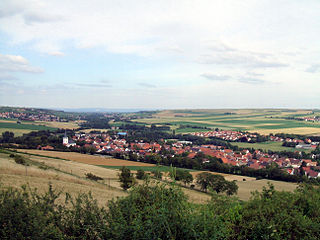
Winnweiler is a municipality in the Donnersbergkreis, in Rhineland-Palatinate, Germany. It is situated on the upper course of the river Alsenz, approx. 15 km (9.3 mi) north-east of Kaiserslautern. Winnweiler is the seat of the Verbandsgemeinde Winnweiler. Winnweiler station is on the Alsenz Valley Railway (Alsenztalbahn), running between Hochspeyer and Bad Münster am Stein.

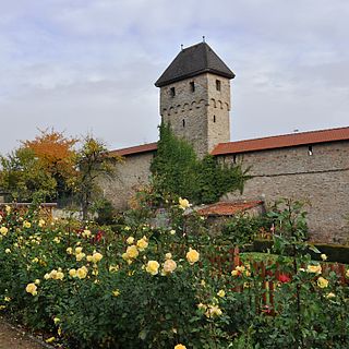
Obermoschel is a town and municipality in the district Donnersbergkreis, Rhineland-Palatinate, Germany. With around 1,000 residents, it is the smallest town in the Palatinate (Pfalz). It is part of the Verbandsgemeinde Nordpfälzer Land, which has its seat of administration in community of Rockenhausen and an administrative office in Alsenz. According to regional planning, Obermoschel is designated as lower-order center (Grundzentrum).

Berglangenbach is an Ortsgemeinde – a municipality belonging to a Verbandsgemeinde, a kind of collective municipality – in the Birkenfeld district in Rhineland-Palatinate, Germany. It belongs to the Verbandsgemeinde of Baumholder, whose seat is in the like-named town.
Sembach is a municipality in the district of Kaiserslautern in the state of Rhineland-Palatinate, Germany. It forms part of the Verbandsgemeinde of Enkenbach-Alsenborn. The town is nestled in the Palatinate Forest Nature Park between Kaiserslautern and Donnersbergkreis. Sembach was first mentioned in the 13th century, in a document about a donation to the monastery of Enkenbach.

Wachenheim is an Ortsgemeinde – a municipality belonging to a Verbandsgemeinde, a kind of collective municipality – in the Alzey-Worms district in Rhineland-Palatinate, Germany.

Schmittweiler is an Ortsgemeinde – a municipality belonging to a Verbandsgemeinde, a kind of collective municipality – in the Bad Kreuznach district in Rhineland-Palatinate, Germany. It belongs to the Verbandsgemeinde of Meisenheim, whose seat is in the like-named town.

Bisterschied is a municipality in the Donnersbergkreis district, in Rhineland-Palatinate, Germany. Bennhausen has an area of 5.16 km² and a population of 232.

Dannenfels is a municipality in the Donnersbergkreis district, in Rhineland-Palatinate, Germany.

Gerbach is a municipality in the Donnersbergkreis district, in Rhineland-Palatinate, Germany.

Gundersweiler is a village and a municipality in the Verbandsgemeinde Nordpfälzer Land and the Donnersbergkreis district, in Rhineland-Palatinate, Germany. It is located in the valley of Moschelbach in the North Palatine Uplands, southwest of Donnersberg and between Kaiserslautern and Bad Kreuznach.
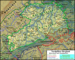
The North Palatine Uplands, sometimes shortened to Palatine Uplands, is a low mountain range and landscape unit in the German state of Rhineland-Palatinate and belongs mainly to the Palatinate region. It is part of the Saar-Nahe Uplands.
The Zellertal is a valley region in the east of the North Palatine Uplands in the German state of Rhineland-Palatinate. Its western part belongs to Palatine Donnersbergkreis, its eastern part to Rhenish Hessian Alzey-Worms. The valley is named after the old municipality of Zell, which became part of the new Zellertal municipality in 1976.

The Pfrimm Viaduct, colloquially also called the Marnheim Bridge, was a railway bridge near Marnheim in the county of Donnersbergkreis in the German state of Rhineland-Palatinate. It was built as a stone arch and truss bridge from 1872 to 1874, was 260 metres long and 30 metres high, and carried the Donnersberg Railway from Hungerberg over the valley of the Pfrimm to the Zeller Valley Railway, which is only open at weekends today. The bridge is a protected monument and forms the "Gateway to the Zellertal".


