Gauersheim

Last updated
Gauersheim
Ansicht von Gauersheim (2021).jpg
DEU Gauersheim COA.svg
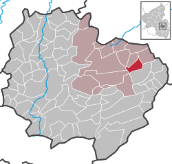
Location of Gauersheim within Donnersbergkreis district
Gauersheim in KIB.svg
Germany adm location map.svg
Red pog.svg
Gauersheim
Rhineland-Palatinate location map.svg
Red pog.svg
Gauersheim
Coordinates: 49°39′35.5104″N8°4′22.1772″E / 49.659864000°N 8.072827000°E / 49.659864000; 8.072827000
Country Germany
State Rhineland-Palatinate
District Donnersbergkreis
Municipal assoc. Kirchheimbolanden
Government
   Mayor (201924) Reiner Schlesser [1]
Area
  Total
5.25 km2 (2.03 sq mi)
Elevation
205 m (673 ft)
Population
 (2022-12-31) [2]
  Total
675
  Density130/km2 (330/sq mi)
Time zone UTC+01:00 (CET)
  Summer (DST) UTC+02:00 (CEST)
Postal codes
67294
Dialling codes 06355
Vehicle registration KIB
Website kirchheimbolanden.de
protestant church Gauersheim Protestantische Kirche.JPG
protestant church

Gauersheim is a municipality in the Donnersbergkreis district, in Rhineland-Palatinate, Germany.

Contents

Geography

The village is situated in the Alzey Hills part of the Rhenish-Hessian Hills, about 4 km (2.5 mi) east of Kirchheimbolanden. Neighbouring municipalities are Stetten, Albisheim, Marnheim, Bolanden, Kirchheimbolanden, Bischheim and Rittersheim.

The west of the district is occupied by the Hungerberg hill, an up to 302 m (990 ft) high plateau. The Leiselbach stream flows through the village.

History

Etymology

The name „Gauersheim“ indicates a frankish establishment, which often end with the Suffix -heim (meaning ‚home‘ or ‚homestead‘). Preceding that is the frankish forename Gawirich, making Gauersheim the „home of Gawirich“.

History

Early history

Neolithic tools and Roman shards have been found in the area. [3]

Early Middle Ages

Gauersheim first appeared in 835 as „Gouurichesheim“ in a document, which proves the donation of the village to Prüm Abbey by emperor Louis the Pious. [4] Viticulture is documented since 893.

High/Late Middle Ages

Around 1200 the counts of Leiningen as fiefs of Prüm Abbey; the Rheingrafen as fiefs of the Elector of Mainz and the Bolanden family held rights and claims to Gauersheim. A local dynasty, the Knights of Gauersheim are mentioned in documents between 1222 and 1447. In the 14th century the Waldgraves ruled over the village. [3] In the 15th century the knights Steben von Einselthum owned parts of Gauersheim, as well as the knights of Oberstein. After the death of childless Friedrich Steben von Einselthum in 1549, his cousin Hans IX. of Walbrunn inherited the Einselthums parts. In 1614 the barons of Walbrunn bought the rest of the village making them the sole rulers over Gauersheim. [5]

Modern era

After the War of the First Coalition Gauersheim was occupied and later annexed by France with the Treaty of Campo Formio in 1797. From 1798 to 1814 it belonged to the French Departement du Mont-Tonnerre. After the Congress of Vienna the region was first given to Austria (1815) and later to Bavaria (1816). In 1815 the village had 488 inhabitants.

After World War II Gauersheim became part of Rhineland-Palatinate (1946). Since 1969 it belongs to the Donnersbergkreis district.

Politics

Council

The village council is composed of 12 members who were elected in a personalized proportional representation in the local elections on June 9, 2024, and the honorary mayor as chairman. [6]

Heraldry

The coat of arms depicts the Virgin Mary holding Jesus. Below her are two smaller shields depicting the blazons of the Knights of Oberstein (lion) and the Barons of Wallbrunn (lozenges).

Religion

The protestant church in the village center is the parish church for Gauersheim, Ilbesheim, Rittersheim and Stetten. [7] It was built in the 13th century and expanded in 1751.

Culture and sights

Cultural heritage monuments

Nature

A large plane tree next to the church is a protected natural monument.

Festivals

Economy and infrastructure

Economy

Gauersheim is part of the Palatinate wine region. There are 20 ha (50 ac) of vineyards in the municipality on the southern slope of the valley.

A wind farm was built between 2013 and 2015 which is partly inside Gauersheim‘s municipal borders.

Infrastructure

The A63 highway is about 4 km (2.5 mi) west of Gauersheim. The nearest train stations are situated in Albisheim and Kirchheimbolanden, from which only the latter is served by passenger trains regularly. Bus lines 904, 907 and 928 of the VRN serve the village. [10]

References

  1. Direktwahlen 2019, Donnersbergkreis, Landeswahlleiter Rheinland-Pfalz, accessed 9 August 2021.
  2. "Bevölkerungsstand 2022, Kreise, Gemeinden, Verbandsgemeinden" (PDF) (in German). Statistisches Landesamt Rheinland-Pfalz. 2023.
  3. 1 2 Denkmaltopographie Bundesrepublik Deutschland. Band 15: Donnersbergkreis, Werner'sche Verlagsbuchhandlung, Worms 1998, S. 292 ff.
  4. Ludwig Wasem (1985), Nordpfälzer Geschichtsverein Rockenhausen (ed.), Die Kirchen der Nordpfalz, Otterbach: Verlag Franz Arbogast, pp. 28–29
  5. Gerald F. W. Müller, Treffen der Familien von Wallbrunn-Besichtigung des Residenzortes Gauersheim am 13. Juni 2009, Pfaffen-Schwabenheim 2009, p. 1 ff.
  6. "Gemeinderatswahl 2024 Gauersheim" (in German). Landeswahlleiter Rheinland-Pfalz. Retrieved 2024-08-16.
  7. "Protestantisches Pfarramt Gauersheim". Evangelische Kirche der Pfalz (Protestantische Landeskirche). Retrieved 2024-08-23.
  8. Erhard Besler (2022-09-22). "Kerwe in Gauersheim: Vom Schlachtfest bis zum „Schobbelauf"". rheinpfalz.de (in German). Die Rheinpfalz. Retrieved 2025-03-18.
  9. Karin Hoffmann (2024-11-08). "Adventsbasar am Dorfgemeinschaftshaus in Gauersheim". wochenblatt-reporter.de (in German). Die Rheinpfalz. Retrieved 2025-03-18.
  10. "Behles Fahrpläne Donnersbergkreis". behles-bus.de (in German). Retrieved 2024-08-16.