
Berwick-upon-Tweed, sometimes known as Berwick-on-Tweed or simply Berwick, is a town and civil parish in Northumberland, England, 2.5 mi (4 km) south of the Anglo-Scottish border, and the northernmost town in England. The 2011 United Kingdom census recorded Berwick's population as 12,043.

Ancroft is a village and civil parish in Northumberland, England. Prior to 1844, Ancroft lay within the Islandshire exclave of County Durham. It is south of Berwick-upon-Tweed, and has a population of 885, rising slightly to 895 at the 2011 census.
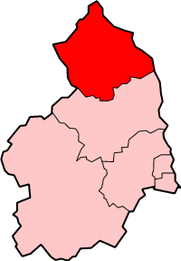
Berwick-upon-Tweed was a local government district and borough in Northumberland in the north-east of England, on the border with Scotland. The district had a resident population of 25,949 according to the 2001 census, which also notes that it is the most ethnically homogeneous in the country, with 99.6% of the population recording themselves in the 2001 census as White. It was also the least populated district in England with borough status, and the third-least densely populated local government district.

Berwick-upon-Tweed was a parliamentary constituency in Northumberland represented in the House of Commons of the UK Parliament from 2015 until its abolition for the 2024 general election by Anne-Marie Trevelyan, a Conservative.

Glanton is a small rural village, in the county of Northumberland, England. Agriculture dominates the surrounding area.

Tweedmouth is part of the town of Berwick-upon-Tweed in Northumberland, England. It is located on the south bank of the River Tweed and is connected to Berwick town centre, on the north bank, by two road bridges and a railway bridge. Tweedmouth has historically always been part of England, in contrast to the walled town of Berwick which came under Scottish control for several periods in the Middle Ages. The local nickname for people from Tweedmouth is "Twempies". In 1951 the parish had a population of 6410.

Bowsden is a village and civil parish in Northumberland, England. It is about 6 miles (10 km) to the south of Berwick-upon-Tweed, inland from the North Sea coast at Lindisfarne, and has a population of 157, rising to 178 at the 2011 Census.

Capheaton is a village and civil parish in Northumberland, England, about 25 miles (40 km) to the northwest of Newcastle upon Tyne. The population at the 2001 census was 160, increasing to 175 at the 2011 Census. It was built as a planned model village in the late eighteenth century. The name Capheaton derives from Caput Heaton, i.e., Heaton Magna, nearby Kirkheaton being the original Heaton Parva.

Matfen is a village and a civil parish in Northumberland, England, near the town of Hexham and the city of Newcastle upon Tyne. It is an example of a 19th-century planned estate village. It was the birthplace of the 7th Premier of British Columbia, William Smithe. In 2001 it had a population of 495.

Powburn is a small village on the A697 in Northumberland, England about 8 miles (13 km) south of Wooler and 10 miles (16 km) northwest of Alnwick.

Lowick is a village in Northumberland, north east England. Lowick lies on the B6353 road, about 10 miles (16 km) south of Berwick-upon-Tweed. The Anglican St John the Baptist's Parish Church dates from 1794, but a chapel was built in the 12th century by monks of Lindisfarne. The Grade II* listed Barmoor Castle, a castellated Tudor-style country house, is about a mile to the west of the village.
Middleton is a settlement and civil parish in Northumberland, England. The parish is situated on the North Sea coast, south of the island of Lindisfarne, and contains the villages of Ross, Detchant and Elwick; all are shrunken medieval villages. Both the A1 London to Edinburgh road and East Coast Main Line pass through the parish. In the 2001 census the parish had a population of 136, falling to 115 at the 2011 Census.

Kirkheaton is a village and former civil parish, now in the parish of Capheaton, in the county of Northumberland, England. The village lies about 10 miles (16 km) north east of Hexham and about 5 miles (8 km) west of Belsay. In 1951 the parish had a population of 70.

Netherwitton is a village in Northumberland, England about 8 miles (13 km) west north west of Morpeth.

Horton is a pair of small settlements, West Horton and East Horton, divided by a stream - the Horton Burn - in Northumberland, England 3 miles (5 km) north east of Wooler and 5 miles (8 km) west of Belford. Horton Moor is north of the settlements.

The Devil's Causeway is a Roman road in Northumberland, in North East England. It branches off Dere Street north of Corbridge and can be traced through Northumberland for about 55 miles (89 km) north to Berwick-upon-Tweed.

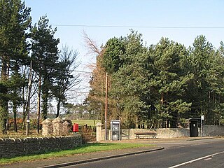
Goswick is a hamlet in Northumberland, England, situated approximately south-east of Berwick-upon-Tweed, England, between the A1 and the North Sea coast.

The Northumberland Coast Path is a long distance path in Northumberland in northern England. It now forms part of the England Coast Path.
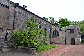
Our Lady and St Cuthbert Church is a Roman Catholic parish church in Berwick-upon-Tweed, Northumberland, England. It was built in 1829 in the Gothic Revival style, intentionally hidden away from the street. It is located on Ravensdowne to the south of Berwick Barracks in the centre of the town. It is a Grade II listed building.

