
Gloucestershire is a county in South West England. The county comprises part of the Cotswold Hills, part of the flat fertile valley of the River Severn, and the entire Forest of Dean.

The Forest of Dean is a geographical, historical and cultural region in the western part of the county of Gloucestershire, England. It forms a roughly triangular plateau bounded by the River Wye to the west and northwest, Herefordshire to the north, the River Severn to the south, and the City of Gloucester to the east.
Cinderford is a small town and civil parish on the eastern fringe of the Forest of Dean in Gloucestershire, England, which had a population of 8,494 at the 2011 census.

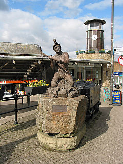
Coleford is a market town in the west of the Forest of Dean, Gloucestershire, England, two miles (3.2 km) east of the Welsh border and close to the Wye Valley. It is the administrative centre of the Forest of Dean district. The combined population of the town's two electoral wards at the 2011 census was 8,359.

Forest of Dean is a parliamentary constituency represented in the House of Commons of the UK Parliament since 2005 by Mark Harper, a Conservative.

Newnham or Newnham on Severn is a village in west Gloucestershire, England. It lies in the Royal Forest of Dean, on the west bank of the River Severn, approximately 10 miles south-west of Gloucester and three miles southeast of Cinderford. It is on the A48 road between Gloucester and Chepstow, Monmouthshire, Wales. The village has a parish council.

St Briavels is a medium-sized village and civil parish in the Royal Forest of Dean in west Gloucestershire, England; close to the England-Wales border, and 5 miles (8 km) south of Coleford. It stands almost 800 feet (240 m) above sea level on the edge of a limestone plateau above the valley of the River Wye, above an ancient meander of the river. To the west, Cinder Hill drops off sharply into the valley.

English Bicknor is a village and civil parish in the Forest of Dean district of west Gloucestershire, England. The 2011 Census recorded the population as 408. The village is near the county boundary with Herefordshire, opposite which is the village of Welsh Bicknor. The two villages are on opposite sides of the River Wye.

Five Acres High School, formerly Lakers School, is an academy in Coleford, Gloucestershire. Ian Frost is the Headteacher, Five Acres is an Academy which is sponsored by the Greenshaw Learning Trust.

Newland is a village in the Forest of Dean in Gloucestershire, England. situated on the east side of the River Wye, 3 miles south-east of Monmouth. It is notable for its parish church of All Saints, known as the 'Cathedral of the Forest'. It was the centre of a large parish with complex boundaries and scattered settlements.

Littledean is a village in the Forest of Dean, west Gloucestershire, England. The village has a long history and formerly had the status of a town. Littledean Hall was originally a Saxon hall, although it has been rebuilt and the current house dates back to 1612. The remains of a Roman temple are situated in the grounds. Neither the hall or Roman remains are open to the public.

Coalway is a village in the West Forest of Dean region of Gloucestershire, England, approximately one mile south-east of the town of Coleford. The village is just south of the village of Broadwell.

Hartpury is a civil parish in Gloucestershire, England. It has an area of about 3,500 acres (1,400 ha), about 270 homes and a population of about 700 people, increasing dramatically to 1,642 at the 2011 census The village is about 5 miles (8 km) north of Gloucester. Geographically the parish is in Leadon Vale; administratively it is in the Forest of Dean. Hartpury also presents beautiful walks and strolls through the countryside. It has all the usual facilities; Post Office, a school, church and a vets. Hartpury College is based in the village. The village contains several interesting buildings including the former home of the Canning family, Hartpury House, now part of the college. Hill House, also known as The Hill, is a large timber framed house which contains a very fine 16th Century oak staircase and several plaster ceilings of the same period.

Staunton is a village and civil parish in the Forest of Dean in west Gloucestershire, England, close to the border with Wales.

West Dean is a civil parish, situated in the Forest of Dean district of Gloucestershire, England.
Broadwell is a village about 1 mile (1.6 km) east of Coleford, Gloucestershire, England. It is at the western edge of the Forest of Dean, in the civil parish of Coleford, which is also its post town. The village of Mile End is to the north and Coalway is to the south.

Coleford Great Western Railway Museum is a railway museum located in Coleford, Gloucestershire, England. The museum was founded in 1988. Based in the former GWR Goods Shed along the Coleford Railway. There was also another station situated at Coleford, it was opened by the Severn and Wye Railway. The Museum traces the history of all the railways in the Forest of Dean, Gloucestershire from the early 19th century when the first plateways were laid, to the 1970s when the Dean Forest Railway was founded. The Museum has information about the Wye Valley Railway, Severn & Wye Railway and Monmouth Troy railway station.
Hewelsfield is a village in Hewelsfield and Brockweir civil parish, in the Forest of Dean district of Gloucestershire, England.
Mile End is a small village in the English county of Gloucestershire. It belongs to the civil parish of Coleford, which is also its post town. Mile End is 1 mile (1.6 km) northeast of Coleford. The village lies at the western edge of the Forest of Dean. The village merges with the village of Broadwell to the south.

