
The Forest of Dean is a geographical, historical and cultural region in the western part of the county of Gloucestershire, England. It forms a roughly triangular plateau bounded by the River Wye to the west and northwest, Herefordshire to the north, the River Severn to the south, and the City of Gloucester to the east.
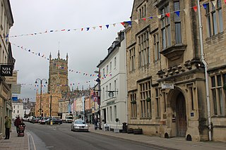
Cotswold is a local government district in Gloucestershire, England. It is named after the wider Cotswolds region and range of hills. The council is based in the district's largest town of Cirencester. The district also includes the towns of Chipping Campden, Fairford, Lechlade, Moreton-in-Marsh, Northleach, Stow-on-the-Wold and Tetbury, along with numerous villages and surrounding rural areas.
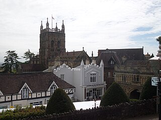
Malvern Hills is a local government district in Worcestershire, England. Its council is based in Malvern, the district's largest town. The district also includes the towns of Tenbury Wells and Upton-upon-Severn and a large rural area covering much of the western side of the county, including numerous villages. The district is named after the Malvern Hills, which are a designated Area of Outstanding Natural Beauty.

Stroud District is a local government district in Gloucestershire, England. The district is named after its largest town of Stroud. The council is based at Ebley Mill in Cainscross. The district also includes the towns of Berkeley, Dursley, Nailsworth, Stonehouse and Wotton-under-Edge, along with numerous villages and surrounding rural areas. Over half of the district lies within the Cotswolds Area of Outstanding Natural Beauty.

Parkend is a village, located at the foot of the Cannop Valley, in the Royal Forest of Dean, West Gloucestershire, England, and has a history dating back to the early 17th century. During the 19th century it was a busy industrial village with several coal mines, an ironworks, stoneworks, timber-yard and a tinplate works, but by the early 20th century most had succumbed to a loss of markets and the general industrial decline. In more recent times, the village has become a tourist destination.

Forest of Dean is a local government district in west Gloucestershire, England, named after the Forest of Dean. Its council is based in Coleford. Other towns and villages in the district include Blakeney, Cinderford, Drybrook, English Bicknor, Huntley, Littledean, Longhope, Lydbrook, Lydney, Mitcheldean, Newnham and Newent.

Coleford is a market town in the west of the Forest of Dean, Gloucestershire, England, two miles (3 km) east of the Welsh border and close to the Wye Valley. It is the administrative centre of the Forest of Dean district. The combined population of the town's two electoral wards at the 2011 census was 8,359. The population of the town's parish was 9,273 in the 2021 Census. The parish includes the village of Baker's Hill.

Awre is a village, civil parish and electoral ward in the Forest of Dean District of Gloucestershire, England, near the River Severn.

Aylburton is a village and civil parish in the Forest of Dean district of Gloucestershire, England, on the A48 road about two miles south-west of Lydney. According to the 2001 census it had a population of 689, increasing to 711 at the 2011 census.
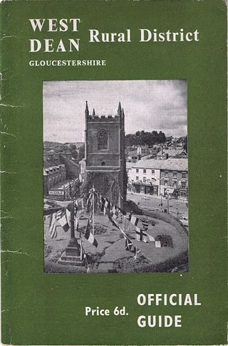
West Dean Rural District was a rural district in Gloucestershire, England, from 1894 to 1974. It comprised a number of civil parishes, including, confusingly, one called West Dean, and gained further territory in 1935.

Berry Hill is a village in Gloucestershire, England, 1.5 miles north of the town of Coleford. Berry Hill includes the settlements of Five Acres to the east, Christchurch in the centre, Shortstanding to the north, and Joyford to the north-east. Berry Hill is within the civil parish of West Dean.
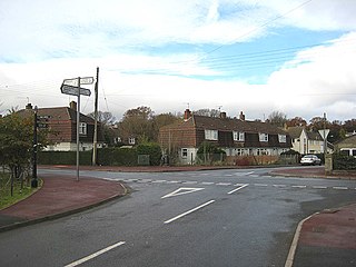
Yorkley is a village in west Gloucestershire, England. The village includes the settlement of Yorkley Slade to the east. Yorkley is situated between the villages of Pillowell and Oldcroft.

Hartpury is a civil parish in Gloucestershire, England. It has an area of about 3,500 acres (1,400 ha). Hartpury Parish Council estimates 700 people live in around 270 houses. The population of the central village area within the parish was estimated at 550 people by Forest of Dean District Council in July 2024, and new housing allocations of 66 additional houses were anticipated by 2041.
Sling is a village in Gloucestershire, England. The village is located between Clearwell and Bream. It is just south of the village of Milkwall.

Whitecroft is a village in the Forest of Dean in west Gloucestershire, England. It is located in-between Bream and Yorkley. Whitecroft comes under the postal district of Lydney.

Hamfallow is a civil parish in the district of Stroud, Gloucestershire. There is no village centre, the parish consists of farms and hamlets such as Abwell, Breadstone, Halmore, Mobley and Wanswell.
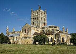
The Borough of Tewkesbury is a local government district with borough status in Gloucestershire, England. The borough is named after its largest town, Tewkesbury, which is where the council is based. The district also includes the town of Winchcombe and numerous villages including Bishops Cleeve, Ashchurch, Churchdown, Innsworth and Brockworth as well as other hamlets and surrounding rural areas. Parts of the district lie within the Cotswolds Area of Outstanding Natural Beauty.

