
Soho is an area of the City of Westminster, itself a part of the West End of London. Originally a fashionable district for the aristocracy, it has been one of the main entertainment districts in the capital since the 19th century.

Leicester Square is a pedestrianised square in the West End of London, England. It was laid out in 1670 as Leicester Fields, which was named after the recently built Leicester House, itself named after Robert Sidney, 2nd Earl of Leicester. The square was originally a gentrified residential area, with tenants including Frederick, Prince of Wales and the artists William Hogarth and Joshua Reynolds. It became more down-market in the late 18th century as Leicester House was demolished and retail developments took place, becoming a centre for entertainment. Major theatres were built in the 19th century, which were converted to cinemas towards the middle of the next. Leicester Square is the location of nationally significant cinemas such as the Odeon Luxe Leicester Square and Empire, Leicester Square, which are often used for film premieres. The nearby Prince Charles Cinema is known for its screenings of cult films and marathon film runs. The square remains a tourist attraction which hosts events, including for the Chinese New Year.

Wardour Street is a street in Soho, City of Westminster, London. It is a one-way street that runs north from Leicester Square, through Chinatown, across Shaftesbury Avenue to Oxford Street. Throughout the 20th century the West End street became a centre for the British film industry and the popular music scene.

Strand is a major thoroughfare in the City of Westminster, Central London. The street, which is part of London's West End theatreland, runs just over 3⁄4 mile (1.2 km) from Trafalgar Square eastwards to Temple Bar, where the road becomes Fleet Street in the City of London, and is part of the A4, a main road running west from inner London.

Belgravia is a district in Central London, covering parts of the areas of the City of Westminster and the Royal Borough of Kensington and Chelsea.

The Metropolitan Borough of Westminster was a metropolitan borough in the County of London, England, from 1900 to 1965.

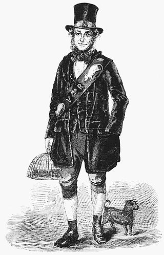
A costermonger, coster, or costard is a street seller of fruit and vegetables in British towns. The term is derived from the words costard and monger (seller), and later came to be used to describe hawkers in general. Some historians have pointed out that a hierarchy existed within the costermonger class and that while costermongers sold from a handcart or animal-drawn cart, mere hawkers carried their wares in a basket.

Pall Mall is a street in the St James's area of the City of Westminster, Central London. It connects St James's Street to Trafalgar Square and is a section of the regional A4 road. The street's name is derived from pall-mall, a ball game played there during the 17th century, which in turn is derived from the Italian pallamaglio, literally "ball-mallet".

Savile Row is a street in Mayfair, central London. Known principally for its traditional bespoke tailoring for men, the street has had a varied history that has included accommodating the headquarters of the Royal Geographical Society at 1 Savile Row, where significant British explorations to Africa and the South Pole were planned; and more recently, the Apple office of the Beatles at 3 Savile Row, where the band's impromptu final live performance was held on the roof of the building.

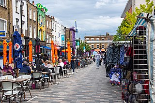
Broadwick Street is a street in Soho, City of Westminster, London. It runs for 0.18 miles (0.29 km) approximately west–east between Marshall Street and Wardour Street, crossing Berwick Street.

Soho Square is a garden square in Soho, London, hosting since 1954 a de facto public park let by the Soho Square Garden Committee to Westminster City Council. It was originally called King Square after Charles II, and a much weathered statue of the monarch has stood in the square, with an extended interruption, since 1661, one year after the restoration of the monarchy.
Inverness Street Market is an outdoor street market in Camden, North London. Licences to trade are issued by Camden London Borough Council.
London Labour and the London Poor is a work of Victorian journalism by Henry Mayhew. In the 1840s, he observed, documented and described the state of working people in London for a series of articles in a newspaper, the Morning Chronicle, which were later compiled into book form.
During the 19th century, London grew enormously to become a global city of immense importance. It was the largest city in the world from about 1825, the world's largest port, and the heart of international finance and trade. Railways connecting London to the rest of Britain, as well as the London Underground, were built, as were roads, a modern sewer system and many famous sites.

Poland Street is a street in the Soho district of the City of Westminster, London. It runs from Oxford Street in the north to Broadwick Street in the south. It was named after the "King of Poland" pub, which was renamed in honour of Poland's King John III Sobieski in the heading of a coalition of western armies, crucially defeated the invading Ottoman forces at the 1683 Battle of Vienna. In the eighteenth century, Polish Protestants settled around Poland Street as religious refugees fleeing the Polish Counterreformation.

The Green Man is a Grade II listed public house at 57 Berwick Street, in London's Soho.

Chalton Street Market is a street market in Camden, North London.
Street trading is selling from a stall, stand, or vehicle in the street rather than in a market hall or square. A collection of regular, and adjacent, street traders forms a street market. Where traders operate on their own, from a regular location, these are variously described as isolated pitches, scattered sites, or miscellaneous sites. Peripatetic traders are termed pedlars.

Plender Street Market is an outdoor street market in Camden, North London. Licences to trade are issued by Camden London Borough Council.

Leather Lane Market is an outdoor street market in the Holborn area of the London Borough of Camden. Taking place on Leather Lane, it is the oldest street market in Camden. Licences to trade are issued by Camden London Borough Council.


