
Kingston upon Thames is a town in the Royal Borough of Kingston upon Thames, southwest London, England. It is situated on the River Thames and 10 miles (16 km) southwest of Charing Cross. It is notable as the ancient market town in which Saxon kings were crowned and today is the administrative centre of the Royal Borough.

Stow-on-the-Wold is a market town and civil parish in Gloucestershire, England, on top of an 800-foot hill at the junction of main roads through the Cotswolds, including the Fosse Way (A429), which is of Roman origin. The town was founded by Norman lords to absorb trade from the roads converging there. Fairs have been held by royal charter since 1330; a horse fair is still held on the edge of town nearest to Oddington in May and October each year.

Cambridge is a university city and the county town in Cambridgeshire, England. It is located on the River Cam approximately 55 miles (89 km) north of London. As of the 2021 United Kingdom census, the population of Cambridge was 145,700. Cambridge became an important trading centre during the Roman and Viking ages, and there is archaeological evidence of settlement in the area as early as the Bronze Age. The first town charters were granted in the 12th century, although modern city status was not officially conferred until 1951.
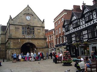
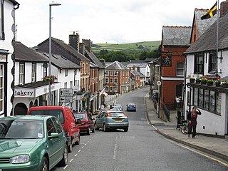
A market town is a settlement most common in Europe that obtained by custom or royal charter, in the Middle Ages, a market right, which allowed it to host a regular market; this distinguished it from a village or city. In Britain, small rural towns with a hinterland of villages are still commonly called market towns, as sometimes reflected in their names.

Shaftesbury is a town and civil parish in Dorset, England. It is situated on the A30 road, 20 miles west of Salisbury, near the border with Wiltshire. It is the only significant hilltop settlement in Dorset, being built about 215 metres above sea level on a greensand hill on the edge of Cranborne Chase.

Marazion is a civil parish and town, on the shore of Mount's Bay in Cornwall, UK. It is 2 miles (3.2 km) east of Penzance and the tidal island of St Michael's Mount is half-a-mile offshore. At low water a causeway links it to the town and at high water passenger boats carry visitors between Marazion and St Michael's Mount. Marazion is a tourist resort with an active community of artists who produce and sell paintings and pottery in the town's art galleries.

Enfield is a large town in north London, England, within the ceremonial county of Greater London and the historic county of Middlesex. It is centred 10.1 miles (16.3 km) north of Charing Cross, and had a population of 156,858 in 2018. It includes the areas of Botany Bay, Brimsdown, Bulls Cross, Bullsmoor, Bush Hill Park, Clay Hill, Crews Hill, Enfield Highway, Enfield Lock, Enfield Town, Enfield Wash, Forty Hill, Freezywater, Gordon Hill, Grange Park, Hadley Wood, Ponders End, and World's End.

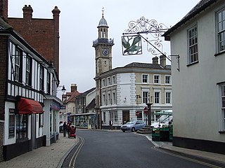
Marlborough is a market town and civil parish in the English county of Wiltshire on the Old Bath Road, the old main road from London to Bath. The town is on the River Kennet, 24 miles (39 km) north of Salisbury and 10 miles (16 km) southeast of Swindon.

Bolton is a large town in Greater Manchester in North West England, formerly a part of Lancashire. A former mill town, Bolton has been a production centre for textiles since Flemish weavers settled in the area in the 14th century, introducing a wool and cotton-weaving tradition. The urbanisation and development of the town largely coincided with the introduction of textile manufacture during the Industrial Revolution. Bolton was a 19th-century boomtown and, at its zenith in 1929, its 216 cotton mills and 26 bleaching and dyeing works made it one of the largest and most productive centres of cotton spinning in the world. The British cotton industry declined sharply after the First World War and, by the 1980s, cotton manufacture had virtually ceased in Bolton.

Petworth is a small town and civil parish in the Chichester District of West Sussex, England. It is located at the junction of the A272 east–west road from Heathfield to Winchester and the A283 Milford to Shoreham-by-Sea road. Some twelve miles (21 km) to the south west of Petworth along the A285 road lies Chichester and the south-coast. The parish includes the settlements of Byworth and Hampers Green and covers an area of 2,690 hectares. In 2001 the population of the parish was 2,775 persons living in 1,200 households of whom 1,326 were economically active. At the 2011 Census the population was 3,027.

Morpeth is a historic market town in Northumberland, North East England, lying on the River Wansbeck. Nearby towns include Ashington and Bedlington. In the 2011 census, the population of Morpeth was given as 14,017, up from 13,833 in the 2001 census. The earliest evidence of settlement is believed to be from the Neolithic period, and some Roman artifacts have also been found. The first written mention of the town is from 1080, when the de Merlay family was granted the barony of Morpeth. The meaning of the town's name is uncertain, but it may refer to its position on the road to Scotland and a murder which occurred on that road. The de Merlay family built two castles in the town in the late 11th century and the 13th century. The town was granted its coat of arms in 1552. By the mid 1700s it had become one of the main markets in England, having been granted a market charter in 1200, but the opening of the railways in the 1800s led the market to decline. The town's history is celebrated in the annual Northumbrian Gathering.

Diss is a market town and electoral ward in South Norfolk, England, near the boundary with Suffolk, with a population of 7,572 in 2011. Diss railway station is on the Great Eastern Main Line between London and Norwich. It lies in the valley of the River Waveney, round a mere covering 6 acres (2.4 ha) and up to 18 feet (5.5 m) deep, although there is another 51 feet (16 m) of mud.
Knighton is a border market town and community in Powys, Wales and Shropshire, England, on the River Teme. It lies on the England–Wales border. The Teme is not navigable in its higher reaches and the border does not follow its course exactly. Originally an Anglo-Saxon settlement, Knighton is located on Offa's Dyke, the ancient earthwork that divided the two countries. It later became a Norman defensive border town.
In England and Wales, charter trustees are set up to maintain the continuity of a town charter or city charter after a district with the status of a borough or city has been abolished, until such time as a parish council is established. Duties are limited to ceremonial activities such as the election of a mayor, and various other functions depending upon local customs and laws.

In England, a civil parish is a type of administrative parish used for local government. It is a territorial designation which is the lowest tier of local government below districts and counties, or their combined form, the unitary authority. Civil parishes can trace their origin to the ancient system of ecclesiastical parishes, which historically played a role in both secular and religious administration. Civil and religious parishes were formally differentiated in the 19th century and are now entirely separate. Civil parishes in their modern form came into being through the Local Government Act 1894, which established elected parish councils to take on the secular functions of the parish vestry.
Penkridge is a Town and civil parish in South Staffordshire District in Staffordshire, England. It is to the south of Stafford, north of Wolverhampton, west of Cannock and east of Telford. The nearby town of Brewood is also not far away.

Coatham is an area of Redcar in the borough of Redcar and Cleveland and the ceremonial county of North Yorkshire, England.
Navenby is a village and civil parish in the North Kesteven district of Lincolnshire, England. Lying 8 miles (13 km) south from Lincoln and 9 miles (14 km) north-northwest from Sleaford, Navenby had a population of 2,128 in the 2011 census and in March 2011, it was named as the 'Best Value Village' in England following a national survey.
A charter fair in England is a street fair or market which was established by Royal Charter. Many charter fairs date back to the Middle Ages, with their heyday occurring during the 13th century. Originally, most charter fairs started as street markets but since the 19th century the trading aspect has been superseded by entertainment; many charter fairs are now the venue for travelling funfairs run by showmen.
Harleston is a town 16 miles (26 km) from Norwich, in the civil parish of Redenhall with Harleston, in the South Norfolk district, in the county of Norfolk, England. In 2018 it had an estimated population of 5067. Harleston is on the Norfolk/Suffolk border, close to the River Waveney. Harleston has 2 markets every Wednesday.

