
Blackfriars is a restored Grade I listed 13th-century priory in Newcastle upon Tyne, Tyne and Wear, England, located in the city centre, close to the city's Chinatown.

John Dobson was a 19th-century English neoclassical architect. During his life, he was the most noted architect in Northern England. He designed more than 50 churches and 100 private houses, but he is best known for designing Newcastle railway station and his work with Richard Grainger developing the neoclassical centre of Newcastle. Other notable structures include Nunnykirk Hall, Meldon Park, Mitford Hall, Lilburn Tower, St John the Baptist Church in Otterburn, Northumberland, and Beaufront Castle.

Throckley is a village in the Newcastle upon Tyne district, in the county of Tyne and Wear, England, approximately 7 miles (11 km) west of Newcastle city centre. Hadrian's Wall passed through the village, its course traced by the village's main road, Hexham Road. Throckley lies within the historic county of Northumberland.

Fenham is an area of the west-end of Newcastle upon Tyne, in the county of Tyne and Wear, England. It lies to the west of the city centre, and is bounded on the north and east by a large area of open land known as the Town Moor. To the south lies Benwell, West Denton lies to the west, Blakelaw and Cowgate to the north, and Arthur's Hill and Spital Tongues to the east. Until 1974 it was in Northumberland.

The history of Newcastle upon Tyne dates back almost 2,000 years, during which it has been controlled by the Romans, the Angles and the Norsemen amongst others. Newcastle upon Tyne was originally known by its Roman name Pons Aelius. The name "Newcastle" has been used since the Norman conquest of England. Due to its prime location on the River Tyne, the town developed greatly during the Middle Ages and it was to play a major role in the Industrial Revolution, being granted city status in 1882. Today, the city is a major retail, commercial and cultural centre.

Bywell is a village and civil parish in Northumberland, England. It is situated on the north bank of the River Tyne opposite Stocksfield, between Hexham and Newcastle. The parish has a population of around 380 and Newton is now its most populous settlement.

The Mitre is a building situated in the Benwell area in the west end of Newcastle upon Tyne, England. It is a Grade II listed building.

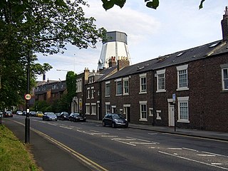
Benwell is an area in the West End of Newcastle upon Tyne, in the county of Tyne and Wear, England. Until 1974 it was in Northumberland.
Spital Tongues is a district of Newcastle upon Tyne, located due north-west of the Newcastle City Centre. Its unusual name is believed to be derived from spital – a corruption of the word hospital, commonly found in British place names - and tongues, meaning outlying pieces of land. North of Spital Tongues is the Town Moor, while Castle Leazes and Leazes Park are to the East.

Twizell Castle is a Grade II* listed building and a Scheduled Ancient Monument which stands on a bend of the River Till at Tillmouth Park, Northumberland, northern England. Below it, the medieval Twizell Bridge spans the river. It is located 10 miles (16 km) south-west of Berwick Upon Tweed. The site is visible from a public footpath, which passes the castle from the road. The gardens of the castle contain the earthwork remains of the once lost medieval village of Twizell, whilst the massive ruin presents the remains of an 18th-century castle which was never completed.

Axwell House is a mansion house and Grade II* listed building, at Axwell Park, Blaydon, Tyne and Wear, England.

The Tyne Theatre and Opera House is a theatre in Newcastle upon Tyne, England. It is a Grade I listed building, rated "in the top 4% of listed buildings" by English Heritage and is afforded a three star rating by the Theatres Trust, "a very fine theatre of the highest theatrical and architectural quality". It opened in 1867 as the Tyne Theatre and Opera House, designed by the Newcastle upon Tyne architecture practice of William Parnell. The backstage area was damaged by fire in 1985, with subsequent rebuilding restoring the Victorian stage machinery.

The Holy Jesus Hospital is a working office in Newcastle upon Tyne, England, in the care of the National Trust. It is a Grade II* listed building.
A chare, in the dialect of North-east England, is a narrow medieval street or alley.

Sandhill Park in the parish of Bishops Lydeard, Somerset, England is a derelict country house built in about 1720. It was used in the 20th century as a prisoner of war camp, a home for handicapped children and later as a military and civilian hospital.

St John's Church is a 13th-century church on the corner of Grainger Street and Westgate Road in Newcastle upon Tyne, England, dedicated to St John the Baptist. It is a Grade I listed building.

Esher Place is a Grade-II listed country house, since 1953 used as a college by the trade union Unite, in Esher, Surrey, United Kingdom. The building is at least the fourth on approximately the same site and mainly dates to the 1890s. It incorporates traces and small parts of some its earlier forebears.

The Guildhall is an important civic building in Newcastle upon Tyne. It is a Grade I listed building.
Bertram Anderson was an English merchant, landowner and politician who represented Newcastle-upon-Tyne and served once as Sheriff, three times as Mayor and was elected five times as MP in the House of Commons between 1553 and 1563 and was also Governor of the Merchant Adventurers of Newcastle-upon-Tyne.
William B. Parnell was an architect active in the 19th century particularly in Newcastle upon Tyne, England. A number of his works on Newcastle Quayside near the then future location of the Tyne Bridge were built following the Great fire of Newcastle and Gateshead in 1854. Noted architect Frank West Rich served as an apprentice under Parnell.

