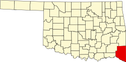
Bethel, McCurtain County, Oklahoma

Last updated

Bethel
USA Oklahoma location map.svg
Red pog.svg
Bethel
Location within the state of Oklahoma
Usa edcp location map.svg
Red pog.svg
Bethel
Bethel (the United States)
Coordinates: 34°21′36.88″N94°50′14.71″W / 34.3602444°N 94.8374194°W / 34.3602444; -94.8374194
Country United States
State Oklahoma
County McCurtain
Time zone UTC-6 (Central (CST))
  Summer (DST) UTC-5 (CDT)
ZIP codes
74724

Bethel is a rural unincorporated community located west of U.S. Route 259 in McCurtain County, Oklahoma, United States. The post office opened January 24, 1900. The ZIP code is 74724.

Bethel Post Office on 7/21/2009. BethelPostOffice.jpg
Bethel Post Office on 7/21/2009.
Bethel Senior Citizen's Center on 7/21/2009. BethelSenCitizenCtr.jpg
Bethel Senior Citizen's Center on 7/21/2009.

This building is not a very active senior citizen's center but they have been known to meet to make quilts and eat. The building is used as a polling place for residents of Bethel and the surrounding area. There are two front doors to the building that open to separate rooms. In the 1980s and prior, people voted on the east side and the votes were manually counted by people on the west side. Currently, the east side is the senior citizen's side as well as the polling place and the west side houses a workout center. The building is about a half of a mile west from the Bethel Post Office.

Bethel Missionary Baptist Church on 7/21/2009. Bethelchurch.jpg
Bethel Missionary Baptist Church on 7/21/2009.

Bethel Missionary Baptist Church is a little less than a half of a mile from the Bethel Post Office. The original building for the church was recently torn down and this picture is the new building. Within the last twenty years, the church has seen a new fellowship hall, a paved parking lot and growth in the church family.

Blake's Grocery & Feed in the original building built in 1923. Picture taken on 7/21/2009. Bethelstore.jpg
Blake's Grocery & Feed in the original building built in 1923. Picture taken on 7/21/2009.

Further reading


Related Research Articles

<span class="mw-page-title-main">Centerville, Georgia</span> City in Georgia, United States

Centerville is a city in Houston County, Georgia, United States. The city is a part of the larger Macon-Warner Robins Combined Statistical Area. It was incorporated March 25, 1958. As of the 2010 census, the city had a population of 7,148, up from 4,278 in 2000. The city's central location, proximity to major highways and interstates, and excellent quality of life makes it one of the top bedroom communities in Georgia. In 2016, Centerville was ranked 7th Happiest City in Georgia by zippia.com, a website devoted to career-related rankings.

<span class="mw-page-title-main">Wappingers Falls, New York</span> Village in New York, United States

Wappingers Falls is a village in the towns of Poughkeepsie and Wappinger, in Dutchess County, New York, United States. As of the 2010 census it had a population of 5,522. The community was named for the cascade in Wappinger Creek. The Wappingers Falls post office covers areas in the towns of Wappinger, Poughkeepsie, Fishkill, East Fishkill, and LaGrange. This can result in some confusion when residents of the outlying towns, who do not live in the village, give their address as "Wappingers Falls".

<span class="mw-page-title-main">Stringtown, Oklahoma</span> Town in Oklahoma, United States

Stringtown is a town in Atoka County, Oklahoma, United States. The population was 410 at the 2010 census, an increase of 3.5 percent from the figure of 396 recorded in 2000. It is the second largest town in Atoka County.

<span class="mw-page-title-main">Pink, Oklahoma</span> Town in Oklahoma, United States

Pink is a town in Pottawatomie County, Oklahoma, United States, and is part of the Oklahoma City Metropolitan Area. The only town in the United States bearing this name, Pink lies within the boundaries of the Citizen Potawatomi Nation. The 2010 census population was 2,058, a 76.7 percent increase from the figure of 1,165 in 2000.

<span class="mw-page-title-main">Shawnee, Oklahoma</span> City in Oklahoma, United States

Shawnee is a city in and the county seat of Pottawatomie County, Oklahoma, United States. The population was 29,857 in 2010, a 4.9 percent increase from the figure of 28,692 in 2000. The city is part of the Oklahoma City-Shawnee Combined Statistical Area and the principal city of the Shawnee Micropolitan Statistical Area.

<span class="mw-page-title-main">Blanchard, Oklahoma</span> City in Oklahoma, United States

Blanchard is a city in McClain and Grady counties in the U.S. state of Oklahoma. The population was 8,879 at the 2020 census, up from 7,670 at the 2010 census. Blanchard is part of a rapidly growing area of northern McClain and Grady counties known as the "Tri-City Area" with Newcastle and Tuttle.

Midland is a town in southern Cabarrus County in the U.S. state of North Carolina. Located in the Charlotte region of North Carolina, Midland is a 30-minute commute to uptown Charlotte. The name of the town is derived from its location approximately halfway between Charlotte and Oakboro on the railroad line. The population was 3,073 at the 2010 census.

<span class="mw-page-title-main">Polling station</span> Place where voters cast their ballots in elections

A polling place is where voters cast their ballots in elections. The phrase polling station is also used in American English and British English, although polling place is the building and polling station is the specific room where voters cast their votes. A polling place can contain one or more polling stations. In Australian English, "polling place" is used.

<span class="mw-page-title-main">Brunswick East, Victoria</span> Suburb of Melbourne, Victoria, Australia

Brunswick East is an inner-city suburb in Melbourne, Victoria, Australia, 5 km (3.1 mi) north of Melbourne's Central Business District, located within the City of Merri-bek local government area. Brunswick East recorded a population of 13,279 at the 2021 census.

<span class="mw-page-title-main">Allegheny Center</span> Neighborhood of Pittsburgh in Allegheny County, Pennsylvania, United States

Allegheny Center is a neighborhood on Pittsburgh's North Side. Its zip code is 15212, and it has representation on Pittsburgh City Council by both council members for District 6 and District 1 (Northside).

<span class="mw-page-title-main">Tuskahoma, Oklahoma</span> Unincorporated community and census-designated place in Oklahoma, United States

Tuskahoma is an unincorporated community and census-designated place in northern Pushmataha County, Oklahoma, United States, four miles east of Clayton. It was the former seat of the Choctaw Nation government prior to Oklahoma statehood. The population at the 2010 census was 151.

<span class="mw-page-title-main">Kenton, Oklahoma</span> Town in Oklahoma, United States

Kenton, located in Cimarron County, Oklahoma, United States, is the westernmost town in Oklahoma. From Kenton, it is approximately 155 miles (249 km) south to Amarillo, Texas, 237 miles (381 km) northwest to Colorado Springs, Colorado, 306 miles (492 km) north-northwest to Denver, Colorado, 314 miles (505 km) southwest to Albuquerque, New Mexico, 340 miles (550 km) northeast to Wichita, Kansas, and 361 miles (581 km) southeast to Oklahoma City, the nearest major population centers.

Tulsa is the second-largest city in the state of Oklahoma and 45th-most populous city in the United States.

<span class="mw-page-title-main">Main Street Historic District (Danbury, Connecticut)</span> Historic district in Connecticut, United States

The Main Street Historic District in Danbury, Connecticut, United States, is the oldest section of that city, at its geographical center. It has long been the city's commercial core and downtown. Its 132 buildings, 97 of which are considered contributing properties, include government buildings, churches, commercial establishments and residences, all in a variety of architectural styles from the late 18th century to the early 20th. It is the only major industrial downtown of its size in Connecticut not to have developed around either port facilities or a water power site.

<span class="mw-page-title-main">Oklahoma Christian University</span> Private Christian university in Oklahoma City

Oklahoma Christian University (OC) is a private Christian university in Oklahoma City, Oklahoma. It was founded in 1950 by members of the Churches of Christ.

Zoraya, pronounced “Zoray”, is a ghost town in western Pushmataha County, Oklahoma, United States, west of Miller.

<span class="mw-page-title-main">Readington Village, New Jersey</span> Populated place in Hunterdon County, New Jersey, US

Readington Village is an unincorporated community located within Readington Township in Hunterdon County, in the U.S. state of New Jersey, that is centered on the converging of Readington Road, Hillcrest Road, Centerville Road and Brookview Road. It is located on Holland Brook, originally named Amanmechunk, which means large creek in the Unami dialect. The area was inhabited by the Raritan prior to the arrival of European settlers. The Native Americans who lived near Readington Village travelled to the coast during the summer for fish and clams. Such a trip is mentioned in an Indian deed transferring lands around Holland Brook to George Willocks, an East and West New Jersey Proprietor. The deed mentions two of the natives, who lived at Readington: Metamisco and Wataminian.

<span class="mw-page-title-main">Des Moines City Hall</span> United States historic place

The Des Moines City Hall is a government building in Des Moines, Iowa, built in 1909 and 1910. It was individually listed on the National Register of Historic Places on November 10, 1977 as the Municipal Building, and became a contributing property in the Civic Center Historic District in 1988. The building serves as the seat for the government of the city of Des Moines. Beginning April 7, 2016, City Hall offices were temporarily relocated while the building underwent renovation. The construction was necessary to install modern heating, cooling, and sprinkler systems while preserving the historic character of the building. The project was expected to take 18–24 months. During that time, City Hall was closed to the public, and City offices moved to other nearby locations. Between February 26, 2018 and April 9, 2018, city offices moved back to City Hall.

<span class="mw-page-title-main">Bethel A.M.E. Church (Indianapolis, Indiana)</span> Historic church in Indiana, United States

The Bethel A.M.E. Church, known in its early years as Indianapolis Station or the Vermont Street Church, is a historic African Methodist Episcopal Church in Indianapolis, Indiana. Organized in 1836, it is the city's oldest African-American congregation. The three-story church on West Vermont Street dates to 1869 and was added to the National Register in 1991. The surrounding neighborhood, once the heart of downtown Indianapolis's African American community, significantly changed with post-World War II urban development that included new hotels, apartments, office space, museums, and the Indiana University–Purdue University at Indianapolis campus. In 2016 the congregation sold their deteriorating church, which will be used in a future commercial development. The congregation built a new worship center at 6417 Zionsville Road in Pike Township, Marion County, Indiana.

<span class="mw-page-title-main">Fairview, Kentucky</span> Census-designated place in Kentucky, United States

Fairview is a small census-designated place on the boundary between Christian and Todd counties in the western part of the U.S. state of Kentucky. As of the 2010 census, it had a population of 286, with 186 living in Christian County and 100 living in Todd County. It is chiefly notable as the birthplace of Jefferson Davis, later President of the Confederate States of America, and as the location of the Jefferson Davis State Historic Site.