Smithville, Oklahoma

Last updated

Smithville, Oklahoma
OKMap-doton-Smithville.PNG
Location of Smithville, Oklahoma
Coordinates: 34°28′08″N94°38′46″W / 34.46889°N 94.64611°W / 34.46889; -94.64611 [1]
Country United States
State Oklahoma
County McCurtain
Area
[2]
  Total1.10 sq mi (2.85 km2)
  Land1.09 sq mi (2.83 km2)
  Water0.01 sq mi (0.02 km2)
Elevation
[1]
742 ft (226 m)
Population
 (2020)
  Total77
  Density70.45/sq mi (27.20/km2)
Time zone UTC-6 (Central (CST))
  Summer (DST) UTC-5 (CDT)
ZIP code
74957
Area code 580
FIPS code 40-68250 [3]
GNIS feature ID2413299 [1]

Smithville is a town in McCurtain County, Oklahoma, United States. Its population was 77 at the 2020 census, [4] down from 113 at the 2010 census. [5] Smithville has the distinction of being the wettest spot in Oklahoma ranked by highest annual average precipitation, at 55.71 inches. [6]

Contents

Geography

Smithville lies in McCurtain County, just east of U.S. Route 259 on Oklahoma Route 4. The town is just north of the Mountain Fork River and about 10 miles north of Broken Bow Lake. [7] The town is among a handful of towns in the southeastern corner of Oklahoma, in an area known as Little Dixie.

According to the United States Census Bureau, the town has a total area of 1.1 square miles (2.8 km2), all land.

Demographics

Historical population
CensusPop.Note
2020 77
U.S. Decennial Census [8]

As of the census of 2010, 113 people, 53 households, and 28 families were residing in the town. [4] The population density was 111 people per square mile (39/km2). The 65 housing units had an average density of 60/sq mi (23/km2). [4] The racial makeup of the town was 58.4% White, 34.5% Native American, and 7.1% from two or more races. [4] Hispanics or Latinos of any race were 2.7% of the population. [4]

Of the 53 households, 32% included children under 18, 34% were married couples living together, 17% had a female householder with no husband present, and 47% were not families. Individuals living alone accounted for 47% of households and those individuals 65 or older living alone accounted for 21% of households. The average household size was 2.13, and the average family size was 3.07. [4]

In the town, theage distribution was 31% under 18, 7% from 18 to 24, 22% from 25 to 44, 25% from 45 to 64, and 15% who were 65 or older. The median age was 32 years. [4]

The median income for a household in the town was $21,136, and for a family was $16,083. [4] The per capita income for the town was $15,674. [4] There were 61.9% of families and 45.2% of the population living below the poverty line. [4]

Notable people

See also

Related Research Articles

Greenbush, officially the Town of Greenbush, is a town in Penobscot County, Maine, United States, on the Penobscot River. The town's population was 1,444 at the 2020 United States Census.

Springfield is a town in Penobscot County, Maine, United States. The population was 293 at the 2020 census.

<span class="mw-page-title-main">Smithville, Missouri</span> City in Missouri, United States

Smithville is a city in Clay and Platte counties in the U.S. state of Missouri and is part of the Kansas City metropolitan area, along the Little Platte River. The population was 10,406 at the 2020 United States Census.

<span class="mw-page-title-main">McDonough, New York</span> Town in New York, United States

McDonough is a town in Chenango County, New York, United States. The population was 886 at the 2010 census. The town is named after Thomas Macdonough, a naval officer who served on Lake Champlain and other locations. McDonough is located in the western part of Chenango County, west of Norwich.

<span class="mw-page-title-main">Smithville, New York</span> Town in New York, United States

Smithville is a town in Chenango County, New York, United States. The population was 1,330 at the 2010 census. The town is at the western border of Chenango County, west of the city of Norwich.

<span class="mw-page-title-main">Smithville, Ohio</span> Village in Ohio, United States

Smithville is a village in Wayne County, Ohio, United States. The population was 1,338 at the time of the 2020 census. The village derives its name from Thomas Smith, a pioneer settler.

<span class="mw-page-title-main">Carter, Oklahoma</span> Town in Oklahoma, United States

Carter is a town in Beckham County, Oklahoma, United States. The population was 183 at the time of the 2020 census.

<span class="mw-page-title-main">Canton, Oklahoma</span> Town in Oklahoma, United States

Canton is a town in Blaine County, Oklahoma, United States. The population was 625 at the 2010 census.

<span class="mw-page-title-main">Ratliff City, Oklahoma</span> Town in Oklahoma, United States

Ratliff City is a town in Carter County, Oklahoma, United States. The population was 120 at the 2010 census. Ratliff City was named for Ollie Ratliff, owner of a local garage. It is part of the Ardmore, Oklahoma Micropolitan Statistical Area.

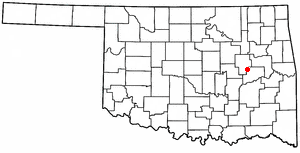
Kinta is a town in Haskell County, Oklahoma, United States. The population was 297 at the 2010 census, an increase of 22.2 percent over the figure of 243 recorded in 2000.

McCurtain is a town in Haskell County, Oklahoma, United States. The population was 357 at the 2020 census, a 30.8% decrease over the figure of 516 recorded in 2010. A coal mine disaster in 1912 killed 73 miners and ended McCurtain's prosperity. The mine explosion remains one of the worst disasters in Oklahoma history.

<span class="mw-page-title-main">Garvin, Oklahoma</span> Town in Oklahoma, United States

Garvin is a town in McCurtain County, Oklahoma, United States. The population was 256 at the 2010 census, compared to 143 in 2000.

<span class="mw-page-title-main">Haworth, Oklahoma</span> Town in Oklahoma, United States

Haworth is a town in McCurtain County, Oklahoma, United States. The population was 297 at the 2010 census.

<span class="mw-page-title-main">Millerton, Oklahoma</span> Town in Oklahoma, United States

Millerton is a town in McCurtain County, Oklahoma, United States. The population was 359 at the 2000 census. The oldest church building in Oklahoma, Wheelock Church, is located near Millerton.

<span class="mw-page-title-main">Hitchita, Oklahoma</span> Town in Oklahoma, United States

Hitchita is a town in McIntosh County, Oklahoma, United States. The Encyclopedia of Oklahoma History and Culture says that the town was named for a band of Muskhogean Indians that had been absorbed into the Creek tribe. The population was 88 at the 2010 census, a decline of 22.1 percent from 113 in 2000.

<span class="mw-page-title-main">Hoffman, Oklahoma</span> Town in Oklahoma, United States

Hoffman is a town in Okmulgee County, Oklahoma, United States. The population was 81 at the 2020 census.

<span class="mw-page-title-main">Osage, Oklahoma</span> Town in Oklahoma, United States

Osage is a town in Osage County, Oklahoma, United States. Also known as Osage City, it lies within the Osage Reservation on the shore of Lake Keystone. The population was 156 at the 2010 census, down 17 percent from the figure of 188 recorded in 2000.

<span class="mw-page-title-main">Bray, Oklahoma</span> Town in Oklahoma, United States

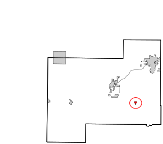
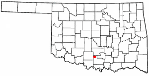
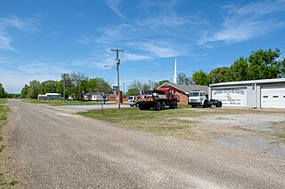
Bray is a town in Stephens County, Oklahoma, United States. The population was 1,209 at the 2010 census.

<span class="mw-page-title-main">Vera, Oklahoma</span> Town in Oklahoma, United States

Vera is a town in Washington County, Oklahoma, United States. The population was 334 as of the 2020 census.

<span class="mw-page-title-main">Surry, Virginia</span> Town in Virginia, United States

Surry is an incorporated town in Surry County, Virginia, United States. The population was 244 at the 2010 census. It is the county seat of Surry County. Its name is derived from the historic county of Surrey in England.
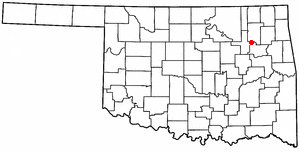
References

  1. 1 2 3 U.S. Geological Survey Geographic Names Information System: Smithville, Oklahoma
  2. "ArcGIS REST Services Directory". United States Census Bureau. Retrieved September 20, 2022.
  3. "U.S. Census website". United States Census Bureau . Retrieved January 31, 2008.
  4. 1 2 3 4 5 6 7 8 9 10 "Smithville town, Oklahoma". United States Census Bureau. Retrieved November 3, 2021.
  5. United States Census 2010 Demographic Profile
  6. "Oklahoma Annual Rainfall and Climate Data". CoolWeather.net. Retrieved April 8, 2021.
  7. Oklahoma Atlas & Gazeteer, DeLorme, 1st ed., 1998, p. 67 ISBN   0899332838
  8. "Census of Population and Housing". Census.gov. Retrieved June 4, 2016.