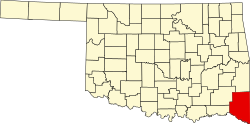
Pecan Point, Texas

Last updated
Pecan Point
USA Texas location map.svg
Red pog.svg
Pecan Point
Location in Texas
Coordinates: 33°44′20″N94°47′20″W / 33.73877300°N 94.78886900°W / 33.73877300; -94.78886900
Country United States
State Texas and Oklahoma
County McCurtain and Red River

Pecan Point is a trading post and ghost town along the Red River of the South, in both McCurtain County, Oklahoma and Red River County, Texas, United States.

History

Previously inhabited by the Natchitoches people, the first settlers were fugitives who arrived in summer 1811. The fugitives abandoned the site by War of 1812 veterans Alex and George Wetmore established the trading post. Another post was later established by William Mabbitt. Settlers Charles Burkham, Claiborne Wright and Walter Pool, and five Indian traders and twelve families settled between 1816 and 1818. [1] [2]

In 1825, Pecan Point's land was bought by Jacob Black, who sold it to Robert Hamilton in January 1835. He used the land to establish Pecan Point Plantation, which was destroyed by the changing river course. [3]

Related Research Articles

<span class="mw-page-title-main">Kickapoo people</span> Native American tribe based in the United States and Mexico

The Kickapoo people are an Algonquian-speaking Native American tribe and Indigenous people in Mexico, originating in the region south of the Great Lakes. Today, three federally recognized Kickapoo tribes are in the United States: the Kickapoo Tribe in Kansas, the Kickapoo Tribe of Oklahoma, and the Kickapoo Traditional Tribe of Texas. The Oklahoma and Texas bands are politically associated with each other. The Kickapoo in Kansas came from a relocation from southern Missouri in 1832 as a land exchange from their reserve there. Around 3,000 people are enrolled tribal members.

<span class="mw-page-title-main">Muscogee</span> Indigenous people from Southeastern Woodlands

The Muscogee, also known as the Mvskoke, Muscogee Creek or just Creek, and the Muscogee Creek Confederacy, are a group of related Indigenous peoples of the Southeastern Woodlands in the United States. Their historical homelands are in what now comprises southern Tennessee, much of Alabama, western Georgia and parts of northern Florida.

<span class="mw-page-title-main">Mills County, Texas</span> County in Texas, United States

Mills County is a county located in Central Texas, United States. It was created on March 15, 1887, from parts of four existing counties—Brown, Comanche, Hamilton, and Lampasas—and named after John T. Mills. The 2020 census reported a population of 4,456. The county seat is Goldthwaite. A long-time resident of the county quipped that residing here is the closest a person could get to living in Mayberry.

<span class="mw-page-title-main">Grayson County, Texas</span> County in Texas, United States

Grayson County is a county in the U.S. state of Texas. As of the 2020 census, its population was 135,543. The county seat is Sherman. The county was founded in 1846 and is named after Peter Wagener Grayson, an attorney general of the Republic of Texas. Grayson County is included in the Sherman-Denison metropolitan statistical area, which is also included in the Dallas-Fort Worth-Arlington, combined statistical area. Located on the state's border with Oklahoma, it is part of the Texoma region, with proximity to Lake Texoma and the Red River.

<span class="mw-page-title-main">Webbers Falls, Oklahoma</span> Town in Oklahoma, United States

Webbers Falls is a town in southeastern Muskogee County, Oklahoma, United States. The population was 616 at the 2010 census, a decline of 14.9 percent from the figure of 724 recorded in 2000.

<span class="mw-page-title-main">Pink, Oklahoma</span> Town in Oklahoma, United States

Pink is a town in Pottawatomie County, Oklahoma, United States, and is part of the Oklahoma City Metropolitan Area. The only town in the United States bearing this name, Pink lies within the boundaries of the Citizen Potawatomi Nation. The population was 2,091 at the time of the 2020 Census, which is 1.6% above the 2010 census figure of 2,058, which itself was a 76.7% increase from the figure of 1,165 in 2000.

<span class="mw-page-title-main">Fulshear, Texas</span> City in Texas, United States

Fulshear is a city in northwestern Fort Bend County, Texas, United States, and is located on the western edge of the Houston–The Woodlands–Sugar Land metropolitan area. The population was 16,856 as of the 2020 census, and according to 2023 census estimates, the city is estimated to have a population of 43,317.

<span class="mw-page-title-main">Seguin, Texas</span> City in Guadalupe County, Texas, United States

Seguin is a city in and the county seat of Guadalupe County, Texas, United States. The population was 29,433 at the 2020 census, and according to 2023 census estimates, the city is estimated to have a population of 36,013.

<span class="mw-page-title-main">Red River of the South</span> Major river in the southern United States

The Red River, or sometimes the Red River of the South to differentiate it from the Red River in the north of the continent, is a major river in the Southern United States. It was named for its reddish water color from passing through red-bed country in its watershed. It is known as the Red River of the South to distinguish it from the Red River of the North, which flows between Minnesota and North Dakota into the Canadian province of Manitoba. Although once a tributary of the Mississippi River, the Red River is now a tributary of the Atchafalaya River, a distributary of the Mississippi that flows separately into the Gulf of Mexico. This confluence is connected to the Mississippi River by the Old River Control Structure.

<span class="mw-page-title-main">Pecan</span> Species of hickory native to the southern USA and northern Mexico

The pecan is a species of hickory native to the southern United States and northern Mexico in the region of the Mississippi River.

<span class="mw-page-title-main">Oklahoma panhandle</span> Panhandle in north-western Oklahoma and former unorganized territory

The Oklahoma Panhandle is a salient in the extreme northwestern region of the U.S. state of Oklahoma. It consists of, from west to east, Cimarron County, Texas County and Beaver County. As with other salients in the United States, its name comes from the similarity of its shape to the handle of a pan. Its largest city is Guymon in Texas County. Black Mesa State Park, located in Cimarron County, is the highest point in the state. Other points of interest include Beaver Dunes Park, Optima Lake, and the Optima National Wildlife Refuge. Oklahoma Panhandle State University is ten miles away from Guymon.

<span class="mw-page-title-main">Black Seminoles</span> Ethnic group

The Black Seminoles, or Afro-Seminoles, are an ethnic group of mixed Native American and African origin associated with the Seminole people in Florida and Oklahoma. They are mostly blood descendants of the Seminole people, free Africans, and escaped former slaves, who allied with Seminole groups in Spanish Florida. Many have Seminole lineage, but due to the stigma of having mixed origin, they have all been categorized as slaves or freedmen in the past.

Miller Court House was the first post office located in what is now Oklahoma, United States. It was located in what was then Miller County, Arkansas Territory. The post office opened September 5, 1824, and was closed December 28, 1839. Miller Court House was the county seat of old Miller County. On January 20, 1825, the land was ceded by treaty to the Choctaw Nation, and non-Native Americans were forced to leave. Before leaving in November 1828, they burned the courthouse and records in protest. The exact site is unknown, but it was in what is now McCurtain County, Oklahoma.

Miller County was a county that existed from April 1, 1820 to 1838, first as part of Arkansas Territory and later the State of Arkansas. It included much of what is southeastern Oklahoma and the northeastern counties in Texas. It was named for James Miller, the first governor of the Arkansas Territory.

<span class="mw-page-title-main">Spanish Fort, Texas</span> United States historic place

Spanish Fort is an unincorporated community in north-central Montague County, Texas, United States. According to the Handbook of Texas, the community had a population of 50 in 2000.

<span class="mw-page-title-main">Arkansas Delta</span> Natural region of Arkansas

The Arkansas Delta is one of the six natural regions of the state of Arkansas. Willard B. Gatewood Jr., author of The Arkansas Delta: Land of Paradox, says that rich cotton lands of the Arkansas Delta make that area "The Deepest of the Deep South."

<span class="mw-page-title-main">Nueces Bay</span> Bay in Texas, United States

Nueces Bay is a northwestern extension of Corpus Christi Bay in the San Patricio and Nueces Counties of Texas. The bay is fed by the Nueces River, forming a natural estuary, which renders it ecologically and economically vital to the surrounding area. It serves as a habitat for the propagation of fish and shellfish, which sustain diverse species of birds and other wildlife. The bay is threatened by pollution from the heavy industry on its southern shore, which prevents oyster farming. Petrochemical production and oil are important to the surrounding economies of the major settlements of Corpus Christi and Portland, found on the eastern shore and connected by the Nueces Bay Causeway at the bay's confluence with Corpus Christi Bay.

Preston, also known as Preston Bend, is an unincorporated community and census-designated place located on the Red River in Grayson County, Texas, United States. It grew in the 19th century at the intersection of several military and trade roads and was an important crossing on the Shawnee cattle trail. Preston lost prominence after the MK&T railroad bypassed the town to the east, leading to a decline in traveler and cattle drive traffic. Much of its former town site is submerged beneath the waters of Lake Texoma. Its population was 2,096 as of the 2010 census.

<span class="mw-page-title-main">1842 Slave Revolt in the Cherokee Nation</span>

The 1842 Slave Revolt in the Cherokee Nation was the largest escape of a group of slaves to occur in the Cherokee Nation, in what was then Indian Territory. The slave revolt started on November 15, 1842, when a group of 20 African-Americans enslaved by the Cherokee escaped and tried to reach Mexico, where slavery had been abolished in 1829. Along their way south, they were joined by 15 slaves escaping from the Creek Nation in Indian Territory.

Jean Baptiste Brevelle was a Parisian-born trader, explorer, and one of the first soldiers garrisoned at Fort St. Jean Baptiste des Natchitoches in present-day Natchitoches, Louisiana and Le Poste des Cadodaquious in Texas.

References

  1. "Pecan Point | The Encyclopedia of Oklahoma History and Culture". Oklahoma Historical Society | OHS. Retrieved 2024-08-28.
  2. Association, Texas State Historical. "Pecan Point, TX". Texas State Historical Association. Retrieved 2024-08-28.
  3. Association, Texas State Historical. "Pecan Point Plantation". Texas State Historical Association. Retrieved 2024-08-28.