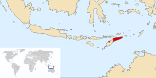
Timor is an island at the southern end of Maritime Southeast Asia, in the north of the Timor Sea. The island is divided between the sovereign states of East Timor in the eastern part and Indonesia in the western part. The Indonesian part, known as West Timor, constitutes part of the province of East Nusa Tenggara. Within West Timor lies an exclave of East Timor called Oecusse District. The island covers an area of 30,777 square kilometres. The name is a variant of timur, Malay for "east"; it is so called because it lies at the eastern end of the Lesser Sunda Islands. Mainland Australia is less than 500 km away, separated by the Timor Sea.
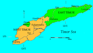
West Timor is an area covering the western part of the island of Timor, except for the district of Oecussi-Ambeno. Administratively, West Timor is part of East Nusa Tenggara Province, Indonesia. The capital as well as its main port is Kupang. During the colonial period, the area was named Dutch Timor and was a centre of Dutch loyalists during the Indonesian National Revolution (1945–1949). From 1949 to 1975 it was named Indonesian Timor.

Central Sulawesi is a province of Indonesia located at the centre of the island of Sulawesi. The administrative capital and largest city is located in Palu. The province borders the provinces of Gorontalo to the east, Southeast Sulawesi, South Sulawesi, and West Sulawesi to the south, and sharing maritime borders with East Kalimantan to the west, North Maluku to the east, and Malaysia and the Philippines to the north.
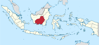
Central Kalimantan is a province of Indonesia. It is one of five provinces in Kalimantan, the Indonesian part of Borneo. It is bordered by West Kalimantan to the west, South Kalimantan and East Kalimantan to the east, Java Sea to the south and is separated narrowly from North Kalimantan and Malaysia by East Kalimantan's Mahakam Ulu Regency. Its provincial capital is Palangka Raya and in 2010 its population was over 2.2 million, while the 2020 Census showed a total of almost 2.67 million; the official estimate as at mid 2023 was 2,774,747, and was projected to rise to 2,809,700 at mid 2024.

East Nusa Tenggara is the southernmost province of Indonesia. It comprises the eastern portion of the Lesser Sunda Islands, facing the Indian Ocean in the south and the Flores Sea in the north. It consists of more than 500 islands, with the largest ones being Sumba, Flores, and the western part of Timor; the latter shares a land border with the separate nation of East Timor. The province is subdivided into twenty-one regencies and the regency-level city of Kupang, which is the capital and largest city.

Surakarta, known colloquially as Solo, is a major city in Central Java, Indonesia. The 46.72 km2 (18.04 sq mi) city adjoins Karanganyar Regency and Boyolali Regency to the north, Karanganyar Regency and Sukoharjo Regency to the east and west, and Sukoharjo Regency to the south. On the eastern side of Solo lies Solo River. Its metropolitan area, consisting of Surakarta City and the surrounding six regencies, was home to 6,837,753 inhabitants according to the official estimates for mid 2023, 526,870 of whom reside in the city proper.
East Timor was a province of Indonesia between 1976 and 1999, during the Indonesian occupation of the country. Its territory corresponded to the previous Portuguese Timor and to the present-day independent country of East Timor.
Atambua is the regency seat of Belu Regency, East Nusa Tenggara, Indonesia.

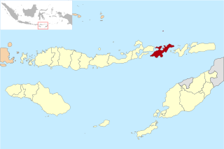
Belu Regency is a regency in East Nusa Tenggara province of Indonesia. Situated on the north side of Timor island, it originally stretched to the south coast, but in December 2012 its southern half was detached to form the new Malaka Regency. It now adjoins the North Central Timor Regency to the west, the new Malaka Regency to the south, and the separate nation of East Timor to the east, while to the north lies the Sawu Sea. Established on 20 December 1958, Belu Regency has its seat (capital) in the large town of Atambua, which lies inland from the coastal port of Atapupu.

The 1999 East Timorese crisis began with attacks by pro-Indonesia militia groups on civilians, and expanded to general violence throughout the country, centred in the capital Dili. The violence intensified after a majority of eligible East Timorese voters voted for independence from Indonesia. Some 1,400 civilians are believed to have died. A UN-authorized force (INTERFET) consisting mainly of Australian Defence Force personnel was deployed to East Timor to establish and maintain peace.
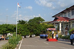
Kefamenanu is a town and capital of the administrative district (kecamatan) of Kota Kefamenanu and of the North Central Timor Regency in West Timor, Indonesia. A road connects it to Halilulik and Kota Atambua to the northeast. It had a population of 43,058 at the 2010 Census and 47,766 at the 2020 Census; the official estimate in mid 2023 was 49,589. The town hosts the University of Timor, one of the two public universities in the Indonesian part of the island.

North Central Timor Regency is a regency in East Nusa Tenggara Province, Indonesia. It covers an area of 2,669.70 km2, and had a population of 229,803 at the 2010 Census and 259,829 at the 2020 Census; the official estimate as at mid 2023 was 271,277. Its regency seat is located at the town of Kefamenanu, which had a population of 49,589 in mid 2023. The regency borders Timor Leste's Oecusse enclave, one of few Indonesian regions that have a land border with other countries.
Lembata Regency is a regency in East Nusa Tenggara province of Indonesia. Established on 4 October 1999 from the most easterly part of East Flores Regency, the regency covers the island of Lembata, together with three small offshore islands together forming the eastern part of the Solor Archipelago, and has its administrative seat (capital) in Lewoleba. The population of the Regency was 117,829 at the 2010 decennial census and at the 2020 census was 135,930; the official estimate as at mid 2023 was 137,812.
The Benanain River is a river of western Timor, Indonesia. This river is the longest and the largest di the West Timor area, with a length of 132 km. The river is located in three regencies: Malaka, Timor Tengah Utara and Timor Tengah Selatan, province East Nusa Tenggara, Indonesia. The upstream rises from Mount Mutis, flowing in the southeast direction until discharging to Timor Sea near Besikama.
Masohi is a coastal town on the Indonesian island of Seram. It is the capital of the Central Maluku Regency. It was the site of a detention camp for political prisoners in the 1970s. It had 36,433 inhabitants at the 2020 census. The headquarters of Manusela National Park is located in Masohi.

Malaka Regency is a regency in the province of East Nusa Tenggara, Indonesia. The regency was established on 14 December 2012, comprising twelve districts which had formerly been the southern part of Belu Regency.

The Poso riots, also known as Poso communal conflict, is a name given to a series of riots that occurred in Poso, Central Sulawesi, Indonesia. This incident involved a group of Muslims and Christians in the region and was divided into three stages. The first Poso riot took place from December 25 to 29, 1998, continued from April 17 to 21, 2000, and finally from May 16 to June 15, 2000.
Salele is a village in East Timor located in the suco of Lalawa in the Tilomar Administrative Post of the Cova Lima Municipality. It is the location of the second main border crossing between the East Timor and Indonesia. The checkpoint on the Indonesian side of the border is called the Motamasin checkpoint.

Central Papua, officially the Central Papua Province is an Indonesian province located in the central region of Western New Guinea. It was formally established on 11 November 2022 from the former eight western regencies of the province of Papua. It covers an area of 61,072.91 km2 and had an officially estimated population of 1,452,810 in mid 2023. It is bordered by the Indonesian provinces of West Papua to the west, the province of Papua to the north and northeast, by Highland Papua to the east, and by South Papua to the southeast. The administrative capital is located in Wanggar District in Nabire Regency, although Timika is a larger town.