
Solapur is a city located in the south-western region of the Indian state of Maharashtra, close to its border with Karnataka. Solapur is located on major highway, rail routes between Mumbai, Pune, Bangalore and Hyderabad, with a branch line to the cities of Kalaburagi and Vijayapura in the neighbouring state of Karnataka. Solapur International Airport is under construction. It is classified as A1 Tier and B-1 class city by House Rent Allowance (HRA) classification by the Government of India. It is the seventh biggest Metropolis Urban Agglomeration and 11th most populated city in Maharashtra as well as 43rd largest urban agglomeration and 49th most populous city in India.

The Kerala backwaters are a network of brackish lagoons and canals lying parallel to the Arabian Sea of the Malabar coast of Kerala state in south-western India. It also includes interconnected lakes, rivers, and inlets, a labyrinthine system formed by more than 900 km (560 mi) of waterways, and sometimes compared to bayous. The network includes five large lakes linked by canals, both man made and natural, fed by 38 rivers, and extending virtually half the length of Kerala state. The backwaters were formed by the action of waves and shore currents creating low barrier islands across the mouths of the many rivers flowing down from the Western Ghats range. In the midst of this landscape there are a number of towns and cities, which serve as the starting and end points of backwater cruises. There are 34 backwaters in Kerala. Out of it, 27 are located either closer to Arabian Sea or parallel to the sea. The remaining 7 are inland navigation routes.

Vembanad is the longest lake in India, as well as the largest in the state of Kerala. The lake has an area of 230 square kilometers and a maximum length of 96.5 km. Spanning several districts in the state of Kerala, it is known as Vembanadu Lake in Kottayam, Vaikom, Changanassery, Punnamada Lake in Alappuzha, Punnappra, Kuttanadu and Kochi Lake in Kochi. Several groups of small islands including Vypin, Mulavukad, Maradu, Udayamperoor, Vallarpadam, and Willingdon Island are located in the Kochi Lake portion. Kochi Port is built around the Willingdon Island and the Vallarpadam island.

The Edwin B. Forsythe National Wildlife Refuge is a U.S. National Wildlife Refuge located in southern and south-central New Jersey, along the Atlantic coast, north of Atlantic City, in Atlantic and Ocean counties. The refuge was created in 1984 out of two existing refuge parcels created to protect tidal wetland and shallow bay habitat for migratory water birds. The Barnegat Division is located in Ocean County on the inland side of Barnegat Bay. The Brigantine Division is located approximately 10 miles (16 km) north of Atlantic City along the south bank of the mouth of the Mullica River. The two divisions are separated by approximately 20 miles (32 km). The refuge is located along most active flight paths of the Atlantic Flyway, making it an important link in the network of national wildlife refuges administered nationwide by the U.S. Fish and Wildlife Service. Forsythe Refuge is a part of the Hudson River/New York Bight Ecosystem and The New Jersey Coastal Heritage Trail Route. The refuge is named for Edwin B. Forsythe, conservationist Congressman from New Jersey. The refuge was named as a Ramsar Site of international importance in 1986.

Lake Nakuru is one of the Rift Valley lakes, located at an elevation of 1,754 m (5,755 ft) above sea level. It lies to the south of Nakuru, in the rift valley of Kenya and is protected by Lake Nakuru National Park.
Baramati ([baːɾamət̪iː]) is a city, a tehsil and a municipal council in Pune district in the state of Maharashtra, India. The city is about 100 km southeast of the city of Pune and about 250 km from Mumbai.

Nal Sarovar Bird Sanctuary, consisting primarily of a 120.82-square-kilometre (46.65 sq mi) lake and ambient marshes, is situated about 64 km to the west of Ahmedabad near Sanand Village, in the Indian state of Gujarat. Mainly inhabited by migratory birds in winter and spring, it is the largest wetland bird sanctuary in Gujarat, and one of the largest in India. It was declared a bird sanctuary in April 1969.

The word Maharashtra, the land of the mainly Marathi-speaking people, appears to be derived from Maharashtri, an old form of Prakrit. Some believe that the word indicates that it was the land of the Mahars and the Rattas, while others consider it to be a corruption of the term 'Maha Kantara', a synonym for 'Dandakaranya'. Maharashtra is the third largest state in India after Rajasthan and Madhya Pradesh. It covers an area of 307,713 km2 and is bordered by the states of Madhya Pradesh to the north, Chhattisgarh to the east, Telangana to the southeast, Karnataka to the south and Goa to the southwest. The state of Gujarat lies to the northwest, with the Union territory of Dadra and Nagar Haveli sandwiched between the borders. Maharashtra has coastline of 720 km.The Arabian Sea makes up Maharashtra's west coast. Maharashtra consists of two major relief divisions. The plateau is a part of the Deccan tableland and the Konkan coastal strip abutting on the Arabian Sea.
Hadapsar is a developed town in eastern Pune City, Maharashtra, India. After 1990, Hadapsar developed into a major industrial area and is now one of the most densely populated and developed areas of Pune District. It is well connected to all parts of city. Distances to popular city centers is: Pune Railway Station 8 km, Lohegaon Airport 8 km, Koregaon Park 5 km, Swargate Bus Stand 7 km and Shivaji Nagar Railway Station 12 km.

Maharashtra attracts tourists from other Indian states and foreign countries. It was the second most visited Indian state by foreigners and fifth most visited state by domestic tourists in the country in 2021. Aurangabad is the tourism capital of Maharashtra.

Ujjani Dam, also known as Bhima Dam or Bhima Irrigation Project, on the Bhima River, a tributary of the Krishna River, is an earthfill cum Masonry gravity dam located near Ujjani village of Madha Taluk in Solapur district of the state of Maharashtra in India.

The Mula-Mutha is a river in India, formed by the confluence of the Mula and Mutha rivers in the city of Pune, Maharashtra state, which later flows into the Bhima River, which itself is a tributary of the Krishna River and finally empties into the Bay of Bengal.
Akyatan Lagoon is a 14700-hectare wetland ecosystem that is designated as Wetland of International Importance by Ramsar Convention. A major stop over for migrating birds, Akyatan is recognized as an Important Bird Area by BirdLife International. It is the single largest green turtle rookery at the Mediterranean, holding 43% of the Mediterranean nesting population.

Daund taluka is a taluka or subdivision of Pune district of the state of Maharashtra in India. The town of Daund is the only major urban area in this predominantly rural area. Daund railway station is a major railway junction. All southern railways are connected to this route, and also divided the Nagar railway to north Indian railway, like Delhi, Solapur division, Daund junction and then joined to the Pune district junction. To reach the Siddhi Vinayak Siddhatek Ganpati temple, one has to travel 14 km to Daund by road.
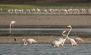
Thol Lake is an artificial lake near Thol village in Kadi in Mehsana District in the Indian state of Gujarat. A fresh water lake surrounded by marshes, it was built as an irrigation tank in 1912. Declared the Thol Bird Sanctuary in 1988, it is a habitat to 150 species of birds, about 60% of them waterbirds. Many migratory birds nest and breed in the lake and its periphery. The two most prominent species of birds recorded in the sanctuary are flamingoes and sarus crane. The sanctuary is also proposed to be declared an Eco-Sensitive Zone, conforming to the Environment (Protection) Act, 1986, for which draft notification has been prepared.
Jubho Lagoon is a large shallow brackish lagoon located in Sindh, Pakistan. In May 2011 Jubhoo lagoon was inducted into the list of Ramsar sites, consisting of wetlands of international importance.

Laul, also known as Sant Shri Kurmadas Maharaj Village, is a village located in Madha Taluka of Solapur District in the State of Maharashtra, in India. It belongs to the Pune Division. It is located 81 km towards west from District headquarter Solapur. It is situated from Kurduvadi Junction(6 km). The village is located at about 380 km from the state capital, Mumbai. Kurdu (5 km), Ghatane (6 km), Ujani Madha (6 km), Padsali (7 km), Ambad (Te) (7 km) are the nearby Villages to Laul. Laul is surrounded by Paranda Taluka towards North, Mohol Taluka towards East, Barshi Taluka towards East, Indapur Taluka towards west. Pandharpur, Kurduvadi, Solapur, Osmanabad are the nearby Cities to Laul. The village follows the Panchayati raj system. Also has a railway track, which used to travel by few people.

Ab-i Istada is an endorheic salt lake in the Nawa District of Ghazni Province in Afghanistan. It lies in a large depression created by the Chaman Fault system in the southern foothills of the Hindu Kush, 125 km (78 mi) west of Ghazni.
Pavana Lake, also known as Pavana Dam Reservoir and Pawna Lake, is a reservoir turned artificial lake in the Indian state of Maharashtra, formed by the Pavana Dam across the Pavana River in Pune district. The reservoir is 25 km from Lonavala and is increasingly getting popular as picnic and camping site for visitors from Pune and Mumbai.
The Panje-Dongri wetlands is located in the coastal town of Uran, Navi Mumbai in Raigad district of Maharashtra in India. It is a major bird watching site in Mumbai Metropolitan Region. The wetland is home to 1.4 lakhs migratory birds in the winter. It is the last surviving wetland at Uran.


