A caldera is a large cauldron-like hollow that forms shortly after the emptying of a magma chamber in a volcanic eruption. An eruption that ejects large volumes of magma over a short period of time can cause significant detriment to the structural integrity of such a chamber, greatly diminishing its capacity to support its own roof, and any substrate or rock resting above. The ground surface then collapses into the emptied or partially emptied magma chamber, leaving a large depression at the surface. Although sometimes described as a crater, the feature is actually a type of sinkhole, as it is formed through subsidence and collapse rather than an explosion or impact. Compared to the thousands of volcanic eruptions that occur over the course of a century, the formation of a caldera is a rare event, occurring only a few times within a given window of 100 years. Only eight caldera-forming collapses are known to have occurred between 1911 and 2018, with a caldera collapse at Kīlauea, Hawaii in 2018. Volcanoes that have formed a caldera are sometimes described as "caldera volcanoes".

Indonesia is an archipelagic country located in Southeast Asia and Oceania, lying between the Indian Ocean and the Pacific Ocean. It is located in a strategic location astride or along major sea lanes connecting East Asia, South Asia and Oceania. Indonesia is the largest archipelago in the world. Indonesia's various regional cultures have been shaped—although not specifically determined—by centuries of complex interactions with its physical environment.

Krakatoa, also transcribed Krakatau, is a caldera in the Sunda Strait between the islands of Java and Sumatra in the Indonesian province of Lampung. The caldera is part of a volcanic island group comprising four islands. Two of them are known as Lang and Verlaten, another, Rakata, is the only remnant of an island mostly destroyed by an eruption in 1883 which created the caldera.

The Bacan Islands, formerly also known as the Bachans, Bachians, and Batchians, are a group of islands in the Moluccas in Indonesia. They are mountainous and forested, lying south of Ternate and southwest of Halmahera. The islands are administered by the South Halmahera Regency of North Maluku Province. They formerly constituted the Sultanate of Bacan.

The Ring of Fire is a tectonic belt of volcanoes and earthquakes.

These lists cover volcanoes by type and by location.

Mount Kerinci, also spelled Kerintji, is an active stratovolcano and the highest mountain in Sumatra, Indonesia. At 12,484 ft (3,805 m) above sea level, it provides Sumatra with the fifth-highest maximum elevation of any island in the world. It is surrounded by the lush forest of Kerinci Seblat National Park, home to several endangered species including the Sumatran tiger. Mount Kerinci is ranked 32nd by topographic isolation.

The Bukit Barisan or the Barisan Mountains are a mountain range on the western side of Sumatra, Indonesia, covering nearly 1,700 km (1,050 mi) from the north to the south of the island. The Bukit Barisan range consists primarily of volcanoes shrouded in dense jungle cover, including Sumatran tropical pine forests on the higher slopes. The highest peak of the range is Mount Kerinci at 3,800 metres (12,467 ft). The Bukit Barisan Selatan National Park is situated towards the southern end of the range in Liwa, Indonesia.

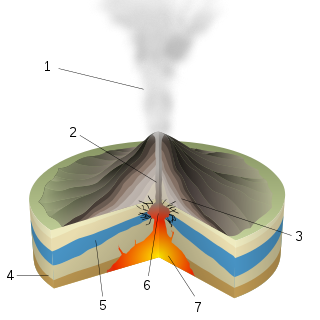
A phreatic eruption, also called a phreatic explosion, ultravulcanian eruption or steam-blast eruption, occurs when magma heats ground water or surface water. The extreme temperature of the magma causes near-instantaneous evaporation of water to steam, resulting in an explosion of steam, water, ash, rock, and volcanic bombs. At Mount St. Helens in Washington state, hundreds of steam explosions preceded the 1980 Plinian eruption of the volcano. A less intense geothermal event may result in a mud volcano.

Mount Agung is an active volcano in Bali, Indonesia, southeast of Mount Batur volcano, also in Bali. It is the highest point on Bali, and dominates the surrounding area, influencing the climate, especially rainfall patterns. From a distance, the mountain appears to be perfectly conical. From the peak of the mountain, it is possible to see the peak of Mount Rinjani on the nearby island of Lombok, to the east, although both mountains are frequently covered in clouds. Agung is a stratovolcano, with a large and deep crater. Its most recent eruptions occurred from 2017–2019.

Mount Rinjani is an active volcano in Indonesia on the island of Lombok. Administratively the mountain is in the Regency of North Lombok, West Nusa Tenggara. It rises to 3,726 metres (12,224 ft), making it the second highest volcano in Indonesia. It is also the highest point in the Indonesian province of West Nusa Tenggara. Adjacent to the volcano is a 6-by-8.5-kilometre caldera, which is filled partially by the crater lake known as Segara Anak or Anak Laut, due to the color of its water, as blue as the sea (laut). This lake is approximately 2,000 metres (6,600 ft) above sea level and estimated to be about 200 metres (660 ft) deep; the caldera also contains hot springs. The lake and mountain are sacred to the Sasak people and Hindus, and are the site of religious rituals. UNESCO made Mount Rinjani Caldera a part of the Global Geoparks Network in April 2018.

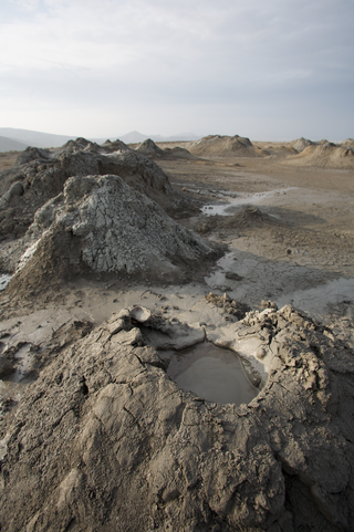
A mud volcano or mud dome is a landform created by the eruption of mud or slurries, water and gases. Several geological processes may cause the formation of mud volcanoes. Mud volcanoes are not true igneous volcanoes as they do not produce lava and are not necessarily driven by magmatic activity. Mud volcanoes may range in size from merely 1 or 2 meters high and 1 or 2 meters wide, to 700 meters high and 10 kilometers wide. Smaller mud exudations are sometimes referred to as mud-pots.

The Kelud is a mountain stratovolcano located in Kediri, East Java, Indonesia. Like many Indonesian volcanoes and others on the Pacific Ring of Fire, Kelud is known for large explosive eruptions throughout its history. More than 30 eruptions have occurred since 1000 AD. In 2007, an effusive explosion filled the crater with a lava dome. It last erupted on 13 February 2014, destroying the lava dome and ejecting boulders, stones and ashes up to West Java about 500 kilometres (310 mi) from Mount Kelud. The crater filled with water during the rainy season.

Anak Krakatau is a volcanic island in Indonesia. On 29 December 1927, Anak Krakatau first emerged from the caldera formed in 1883 by the explosive volcanic eruption that destroyed the island of Krakatoa. There has been sporadic eruptive activity at the site since the late 20th century, culminating in a large underwater collapse of the volcano, which caused a deadly tsunami in December 2018. There has been subsequent activity since. Owing to its young age the island is one of several in the area that are of interest to, and the subject of extensive study by volcanologists.

The Semeru, or Mount Semeru is an active volcano located in East Java, Indonesia. It is located in a subduction zone, where the Indo-Australian plate subducts under the Eurasia plate. It is the highest mountain on the island of Java. The name "Semeru" is derived from Meru, the central world mountain in Hinduism, or Sumeru, the abode of gods. This stratovolcano is Mahameru, meaning "The Great Mountain" in Sanskrit. It is one of the more popular hiking destinations in Indonesia.

A somma volcano, also known as a sommian, is a volcanic caldera that has been partially filled by a new central cone. The type is named after Mount Somma ("Summit"), a stratovolcano in southern Italy with a summit caldera in which the upper cone of Mount Vesuvius has grown. Other examples of somma volcanoes can be found on Russia's Kamchatka Peninsula and the Kuril Islands, stretching south from Kamchatka to Hokkaidō, Japan.

A complex volcano, also called a compound volcano or a volcanic complex, is a mixed landform consisting of related volcanic centers and their associated lava flows and pyroclastic rock. They may form due to changes in eruptive habit or in the location of the principal vent area on a particular volcano. Stratovolcanoes can also form a large caldera that gets filled in by a lava dome, or else multiple small cinder cones, lava domes and craters may develop on the caldera's rim.

Several types of volcanic eruptions—during which material is expelled from a volcanic vent or fissure—have been distinguished by volcanologists. These are often named after famous volcanoes where that type of behavior has been observed. Some volcanoes may exhibit only one characteristic type of eruption during a period of activity, while others may display an entire sequence of types all in one eruptive series.

The Schouten Islands are a group of six small volcanic islands in the province of East Sepik in Papua New Guinea, north of the island of New Guinea. The group is also called Eastern Schouten Islands or Le Maire Islands to separate it from unrelated Schouten Islands in Indonesia. The combined land area is approximately 50 km2 (19 sq mi).


