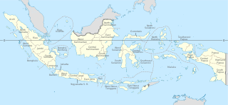
Provinces of Indonesia are the 38 administrative divisions of Indonesia and the highest tier of the local government. Provinces are further divided into regencies and cities, which are in turn subdivided into districts (kecamatan).

Bukittinggi is the third largest city in West Sumatra, Indonesia, with a population of 111,312 in 2010 and 121,028 in 2020, and an area of 25.24 km2. It is in the Minangkabau Highlands, 90 km by road from the West Sumatran capital city of Padang. The whole area directly borders to the Agam Regency, making it an enclave, and is located at 0°18′20″S100°22′9″E, near the volcanoes Mount Singgalang (inactive) and Mount Marapi. At 930 m above sea level, the city has a cool climate with temperatures between 16.1° to 24.9 °C.
A regency, sometimes incorrectly referred to as a district, is an administrative division of Indonesia, directly under a province and on the same level with city (kota). Regencies are divided into districts.
Indonesia is divided into provinces. Provinces are made up of regencies (kabupaten) and cities (kota). Provinces, regencies, and cities have their own local governments and parliamentary bodies.
In Indonesia, village or subdistrict is the fourth-level subdivision and the smallest administrative division of Indonesia below a district, regency/city, and province. There are a number of names and types for villages in Indonesia, with desa being the most frequently used for regencies and kelurahan for cities. According to the 2019 report by the Ministry of Home Affairs, there are 8,488 urban villages and 74,953 rural villages in Indonesia. North Aceh Regency contained the highest number of rural villages (852) amongst all of the regencies of Indonesia, followed by Pidie Regency with 730 rural villages and Bireuen Regency with 609 rural villages. Prabumulih, with only 12 rural villages, contained the fewest. Counted together, the sixteen regencies of Indonesia containing the most rural villages—namely, North Aceh (852), Pidie (730), Bireuen (609), Aceh Besar (604), Tolikara (541), East Aceh (513), Yahukimo (510), Purworejo (469), Lamongan (462), South Nias (459), Kebumen (449), Garut (421), Bojonegoro (419), Bogor (416), Cirebon (412), and Pati (401)—contain one-third of all the rural villages in Indonesia. Five of these are located in Aceh, two in Highland Papua, three in Central Java, two in East Java, three in West Java, and one in North Sumatra. An average number of rural villages in the regencies of Indonesia is 234 villages.
Solok Regency is a regency (kabupaten) of West Sumatra, Indonesia. It covers an area of 3,738 km2 and had a population of 348,566 at the 2010 Census and 391,497 at the 2020 Census. The administrative centre of the regency is the town of Arosuka. The city of Solok is administratively separated from the Regency and its area and population are not included in these totals.

Pesisir Selatan Regency is a regency (kabupaten) of West Sumatra, Indonesia. It has an area of 6,049.33 km² and a population of 429,246 at the 2010 Census and 504,418 at the 2020 Census. The regency seat is at the town of Painan, in IV Jurai District.

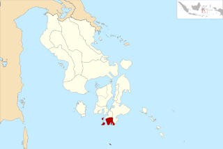
South Solok Regency is a landlocked regency (kabupaten) of West Sumatra province, Indonesia. It covers an area of 3,346.20 km2, and had a population of 144,281 at the 2010 Census and 182,027 at the 2020 Census. The seat of the administration is the town of Padang Aro.

The Emergency Government of the Republic of Indonesia was established by Indonesian Republicans after the Netherlands occupied the at the time capital city of Yogyakarta in Central Java, the location of the temporary Republican capital during the Indonesian National Revolution. It was established in the city of Bukittinggi and led by Sjafruddin Prawiranegara.

Kotabaru Regency is one of the eleven regencies in the Indonesian province of South Kalimantan. It consists of two parts; the smaller but more populated part comprises Laut Island, the largest island off the coast of Kalimantan, together with the smaller Sebuku Island off Laut Island's east coast and even smaller islands nearby; the larger but less populated part consists of districts on the mainland of Kalimantan. The regency has an area of 9,442.46 km2, and had a population of 290,142 at the 2010 Census and 325,622 at the 2020 Census. The official estimate as at mid 2021 was 329,483. The regency seat is located at the large town of Kotabaru at the northern tip of Laut Island.

Sjafruddin Prawiranegara was an Indonesian statesman and economist. He served in various roles during his career, including as head of government in the Emergency Government of the Republic of Indonesia, as Minister of Finance in several cabinets, and as the first Governor of Bank Indonesia. Sjafruddin later became the prime minister of the Revolutionary Government of the Republic of Indonesia, a shadow government set up in opposition to the country's central government.

North Central Timor Regency is a regency in East Nusa Tenggara Province, Indonesia. It covers an area of 2,669.70 km2, and had a population of 229,803 at the 2010 Census and 259,829 at the 2020 Census; the official estimate as at mid 2021 was 262,598. Its regency seat is located at the town of Kefamenanu, which had a population of 48,202 in mid 2021. The regency borders Timor Leste's Oecusse enclave, one of few Indonesian regions that have a land border with other countries.

Southeast Maluku Regency is a regency of Maluku, Indonesia. It is coincident with the Kei Islands, except that the city of Tual, although within the Kei Islands geographically and the seat of the Regency's administration, is technically independent of the Regency. The land area of the Regency is 1,031.81 km2, while the sea area administered by the regency was 3,181 km2; it had a population of 96,442 at the 2010 Census; this increased to 121,511 at the 2020 Census. The capital is located in Langgur.

Teuku Mohammad Hasan was an Indonesian politician and national hero from Aceh, who served as the first and only governor of Sumatra from 1945 until 1948. He also served as a cabinet minister in Sjafruddin Prawiranegara's emergency cabinet and was a member of both the Senate of the United States of Indonesia (USI) and the Provisional People's Representative Council (DPRS) of the Republic of Indonesia.

Koto Baru Grand Mosque is one of the oldest mosques in Indonesia located in Koto Baru Nagari, Sungai Pagu District, South Solok Regency, West Sumatra.
South Buton Regency is a regency located in Southeast Sulawesi. This regency was formed from the southern part of Buton Regency, from which it was separated by Act No.16 of 2014, dated 23 July 2014. It covers an area of 546.58 km2, and the population of the districts now comprising the new regency was 74,974 at the 2010 Census and 95,261 at the 2020 Census; the official estimate as at mid 2021 was 95,472. The regency capital is located in Batauga.
This is a list of emblems or coat of arms used in Indonesia. Indonesia is divided into 38 provinces, and each province is divided into regencies (kabupaten) and cities (kota). There are 416 regencies and 98 cities. Each province, regency, and city has its own emblem.
In Indonesian law, the term "city" is generally defined as the second-level administrative subdivision of the Republic of Indonesia, an equivalent to regency. The difference between a city and a regency is that a city has non-agricultural economic activities and a dense urban population, while a regency comprises predominantly rural areas and is larger in area than a city. However, Indonesia historically had several classifications of cities.
Sangir Jujuan is a district (kecamatan) of South Solok Regency, in the West Sumatra province of Indonesia. It has a population of around 13,700 people.


