Biel, East Lothian

Last updated

Biel
Entrance pillars to Biel, East Lothian - geograph.org.uk - 140927.jpg
Entrance pillars to Biel, East Lothian
East Lothian UK location map.svg
Red pog.svg
Biel
Scotland location map.svg
Red pog.svg
Biel
Location within Scotland
OS grid reference NT634759
Civil parish
Council area
Lieutenancy area
Country Scotland
Sovereign state United Kingdom
Post town DUNBAR
Postcode district EH42
Dialling code 01368
Police Scotland
Fire Scottish
Ambulance Scottish
UK Parliament
Scottish Parliament
List of places
UK
Scotland
55°58′30″N2°35′06″W / 55.975°N 2.585°W / 55.975; -2.585 Coordinates: 55°58′30″N2°35′06″W / 55.975°N 2.585°W / 55.975; -2.585

Biel is a village in East Lothian, Scotland, UK, to the south of Dunbar, off the B6370 road. It is situated on the Biel Estate, close to Biel House.

Contents

Placename

The word 'biel', 'beil' or 'bel' means "shelter", as in Belton, Belhaven, Bilsdean, or as in Robert Lauder of Beilmouth.

History

Archaeologists from Glasgow University found the remains of a small farmstead over 2000 years old, possibly with a palisade surrounding a roundhouse.

The Biel estate was originally owned by the Earls of Dunbar, then by Robert Lauder of The Bass. Sir James Hamilton, Sheriff of Lanark, bought Biel in 1641.

William Hamilton Nisbet succeeded to the Biel lands and made Biel House his residence. It is a 12th-century tower house, off the B6370, and a member of the Historic Houses Association.

Biel House

The present Biel House is a 16th-century three-storey listed building, formerly owned by the Earls of Belhaven. William Atkinson extended it in 1814–1818, and in the early twentieth century, further interior alterations were made by R.R.Anderson. The grounds include a chapel, rock garden, doocot, summerhouse, gatepiers, deer park, woodland, arboretum, kitchen garden, glasshouses.

Biel Water (Biel Burn)

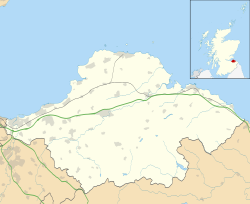
The Biel Water, locally known as the Biel Burn, flows through the Biel Estate, and Biel Mill is situated in a woodland.

The Biel Burn Flood of 1948 is still remembered by local residents. The latest flooding incident occurred in 2007.

See also

Related Research Articles

East Lothian Council area of Scotland

East Lothian is one of the 32 council areas of Scotland, as well as a historic county, registration county and lieutenancy area. The county was also known as Haddingtonshire.

Dunbar Town in East Lothian, Scotland

Dunbar is a town on the North Sea coast in East Lothian in the south-east of Scotland, approximately 30 miles east of Edinburgh and 30 mi (50 km) from the English border north of Berwick-upon-Tweed.

Pencaitland Village in East Lothian, Scotland

Pencaitland is a village in East Lothian, Scotland, about 12 miles south-east of Edinburgh, 5 mi (8 km) south-west of Haddington, and 1 mi (2 km) east of Ormiston.

Belhaven, Scotland Village in East Lothian, Scotland

Belhaven is a village in East Lothian, Scotland, and was originally the ancient port of Dunbar of which town the village has always been a part. Belhaven takes its name from its situation at the mouth of the Biel Water. The village is home to Belhaven Hill School, an independent co-educational prep school for children between the ages of 7–13.

Whittingehame Human settlement in Scotland

Whittingehame is a parish with a small village in East Lothian, Scotland, about halfway between Haddington and Dunbar, and near East Linton. The area is on the slopes of the Lammermuir Hills. Whittingehame Tower dates from the 15th century and remains a residence.

Sir Robert Lauder of the Bass was a Scottish knight, armiger, and Governor of the Castle at Berwick-upon-Tweed. He was also a member of the old Scottish Parliament. The Lauders held the feudal barony of The Bass, East Lothian, Edrington Castle and lands in the parish of Mordington, Berwickshire, Tyninghame in Haddingtonshire, and numerous other estates and properties elsewhere in Scotland.

Archerfield and Archerfield Links are a country house and pair of golf courses in the parish of Dirleton, East Lothian, Scotland. An older golf course, also called Archerfield Links, occupied the area before falling into disuse after World War II.

Linlithgow Town in Scotland

Linlithgow is a town in West Lothian, Scotland. It was historically West Lothian's county town, reflected in the county's historical name of Linlithgowshire. An ancient town, it lies in the Central Belt on an historic route between Edinburgh and Falkirk beside Linlithgow Loch. The town is sutauted approximately 20 miles west of Edinburgh.

Luffness Castle

Luffness Castle, also known as Luffness House, is a house built in a former fortification near the village of Aberlady, East Lothian, Scotland.

Preston Tower, East Lothian

Preston Tower is a ruined L-plan keep in the ancient Scottish village of Prestonpans. It is situated within a few metres of two other historic houses, Hamilton House and Northfield House.

Stenton Human settlement in Scotland

Stenton is a parish and village in East Lothian, Scotland. It is bounded on the north by parts of the parishes of Prestonkirk and Dunbar, on the east by Spott and on the west by Whittingehame. The name is said to be of Saxon derivation. The village has a number of houses, a school, and a church.

Garvald, East Lothian Human settlement in Scotland

Garvald is a village south-east of Haddington in East Lothian, Scotland. It lies on the Papana Water south of the B6370, east of Gifford. The combined parish of Garvald and Bara, borders Whittingehame to the East, Morham to the North, Yester to the West, and Lauder to the South. It is mainly an agricultural parish. The red freestone once constantly mined in this parish was well known throughout the whole country.

Cambo Estate

Cambo Estate lies close to the village of Kingsbarns in north-east Fife, Scotland. It is located in the East Neuk, 10 kilometres (6.2 mi) south-east of St Andrews. At the heart of the estate lies the 19th-century Cambo House, the home of Sir Peter Erskine, Bt and Lady Catherine Erskine. The gardens of Cambo are open to the public, and include the walled garden and seasonal snowdrop gardens. Elsewhere on the estate is the Kingsbarns Golf Links golf course, which co-hosts the Alfred Dunhill Links Championship every year.

Tyninghame House

Tyninghame House is a mansion in East Lothian, Scotland. It is located by the mouth of the River Tyne, 23-mile (1.1 km) east of Tyninghame, and 3+34 miles (6.0 km) west of Dunbar. There was a manor at Tyninghame in 1094, and it was later a property of the Lauder of The Bass family. In the 17th century, it was sold to the Earl of Haddington. The present building dates from 1829 when the 9th Earl of Haddington employed William Burn to greatly enlarge the house in the Baronial style. In 1987 the contents of the house were sold, and the house was divided into flats.

Biel House

Biel House is a historic house on the Biel Estate near Stenton, East Lothian, Scotland. It is a Category A listed building.

Spott, East Lothian Human settlement in Scotland

Spott is a small village on the eastern fringes of East Lothian in Scotland, just over 2 miles (3.2 km) south-west of Dunbar. The village straddles an unclassified road leading from the main A1 highway at grid reference NT673755.

Winton Castle

Winton Castle is a historic building set in a large estate between Pencaitland and Tranent in East Lothian, Scotland. The castle is situated off the B6355 road approximately 0.5 miles (0.80 km) north of Pencaitland at grid reference NT437694.

Biel Water

The Biel Water is a river running through the Biel Estate in Biel, East Lothian. It runs for 4.5 kilometres from the Luggate Burn and the Whittinghame Water, via Stenton, Biel House, West Barns, and finally to Belhaven Bay with its rather unusual bridge, whose ends are submerged at high tide.

Eliburn Human settlement in Scotland

Eliburn is an area, primarily residential, in Livingston, West Lothian, Scotland. Eliburn is borderd by Deans to the north, Ladywell to the west and Livingston Village to the south.

References