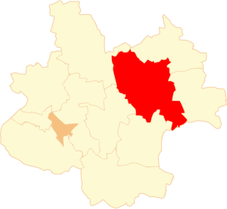
Chrusty is a village in the administrative district of Gmina Aleksandrów Kujawski, within Aleksandrów County, Kuyavian-Pomeranian Voivodeship, in north-central Poland. It lies 6 kilometres (4 mi) west of Aleksandrów Kujawski and 19 km (12 mi) south of Toruń.
Nowy Ciechocinek is a village in the administrative district of Gmina Aleksandrów Kujawski, within Aleksandrów County, Kuyavian-Pomeranian Voivodeship, in north-central Poland. It lies 5 kilometres (3 mi) east of Aleksandrów Kujawski and 21 km (13 mi) south-east of Toruń.
Dobiesławice is a village in the administrative district of Gmina Rojewo, within Inowrocław County, Kuyavian-Pomeranian Voivodeship, in north-central Poland. It lies approximately 5 kilometres (3 mi) south-east of Rojewo, 9 km (6 mi) north of Inowrocław, 29 km (18 mi) south-west of Toruń, and 35 km (22 mi) south-east of Bydgoszcz.
Dźwierzchno is a village in the administrative district of Gmina Złotniki Kujawskie, within Inowrocław County, Kuyavian-Pomeranian Voivodeship, in north-central Poland. It lies approximately 5 kilometres (3 mi) south-west of Złotniki Kujawskie, 15 km (9 mi) north-west of Inowrocław, 29 km (18 mi) south of Bydgoszcz, and 41 km (25 mi) south-west of Toruń.
Husaki is a village in the administrative district of Gmina Bielsk Podlaski, within Bielsk County, Podlaskie Voivodeship, in north-eastern Poland. It lies approximately 13 kilometres (8 mi) north-west of Bielsk Podlaski and 29 km (18 mi) south of the regional capital Białystok.
Porczyny is a village in the administrative district of Gmina Poddębice, within Poddębice County, Łódź Voivodeship, in central Poland. It lies approximately 8 kilometres (5 mi) south-west of Poddębice and 43 km (27 mi) west of the regional capital Łódź.
Zarudki is a village in the administrative district of Gmina Wilków, within Opole Lubelskie County, Lublin Voivodeship, in eastern Poland. It lies approximately 15 kilometres (9 mi) north-west of Opole Lubelskie and 50 km (31 mi) west of the regional capital Lublin.
Chechnówka is a village in the administrative district of Gmina Nasielsk, within Nowy Dwór Mazowiecki County, Masovian Voivodeship, in east-central Poland. It lies approximately 8 kilometres (5 mi) south-east of Nasielsk, 18 km (11 mi) north-east of Nowy Dwór Mazowiecki, and 39 km (24 mi) north of Warsaw.
Unieck is a village in the administrative district of Gmina Raciąż, within Płońsk County, Masovian Voivodeship, in east-central Poland. It lies approximately 12 kilometres (7 mi) north-east of Raciąż, 29 km (18 mi) north-west of Płońsk, and 91 km (57 mi) north-west of Warsaw.
Rosko is a village in the administrative district of Gmina Wieleń, within Czarnków-Trzcianka County, Greater Poland Voivodeship, in west-central Poland. It lies approximately 11 kilometres (7 mi) east of Wieleń, 18 km (11 mi) west of Czarnków, and 66 km (41 mi) north-west of the regional capital Poznań.
Anielin is a village in the administrative district of Gmina Żelazków, within Kalisz County, Greater Poland Voivodeship, in west-central Poland. It lies approximately 13 kilometres (8 mi) north of Kalisz and 101 km (63 mi) south-east of the regional capital Poznań.
Baranowiec is a village in the administrative district of Gmina Dąbie, within Koło County, Greater Poland Voivodeship, in west-central Poland. It lies approximately 5 kilometres (3 mi) north-east of Dąbie, 19 km (12 mi) south-east of Koło, and 137 km (85 mi) east of the regional capital Poznań.
Dąbrowa Mała is a village in the administrative district of Gmina Ślesin, within Konin County, Greater Poland Voivodeship, in west-central Poland. It lies approximately 3 kilometres (2 mi) south-west of Ślesin, 15 km (9 mi) north of Konin, and 92 km (57 mi) east of the regional capital Poznań.
Pępocin is a village in the administrative district of Gmina Słupca, within Słupca County, Greater Poland Voivodeship, in west-central Poland. It lies approximately 11 kilometres (7 mi) east of Słupca and 77 km (48 mi) east of the regional capital Poznań.
Romanowo is a village in the administrative district of Gmina Środa Wielkopolska, within Środa Wielkopolska County, Greater Poland Voivodeship, in west-central Poland. It lies approximately 4 kilometres (2 mi) north of Środa Wielkopolska and 29 km (18 mi) south-east of the regional capital Poznań.
Zielniki is a village in the administrative district of Gmina Środa Wielkopolska, within Środa Wielkopolska County, Greater Poland Voivodeship, in west-central Poland. It lies approximately 4 kilometres (2 mi) north of Środa Wielkopolska and 29 km (18 mi) south-east of the regional capital Poznań.
Rzymsko is a village in the administrative district of Gmina Dobra, within Turek County, Greater Poland Voivodeship, in west-central Poland. It lies approximately 5 kilometres (3 mi) south-east of Dobra, 19 km (12 mi) south-east of Turek, and 132 km (82 mi) south-east of the regional capital Poznań.
Skęczniew is a village in the administrative district of Gmina Dobra, within Turek County, Greater Poland Voivodeship, in west-central Poland. It lies approximately 7 kilometres (4 mi) south-east of Dobra, 21 km (13 mi) south-east of Turek, and 135 km (84 mi) south-east of the regional capital Poznań.
Brzeźno Stare is a village in the administrative district of Gmina Wągrowiec, within Wągrowiec County, Greater Poland Voivodeship, in west-central Poland. It lies approximately 10 kilometres (6 mi) north-east of Wągrowiec and 58 km (36 mi) north-east of the regional capital Poznań.
Konin is a village in the administrative district of Gmina Rędziny, within Częstochowa County, Silesian Voivodeship, in southern Poland. It lies approximately 13 kilometres (8 mi) north-east of Częstochowa and 71 km (44 mi) north of the regional capital Katowice.