
A bifurcation lake is a lake that has outflows into two different drainage basins and thus the drainage divide cannot be defined exactly because it is situated in the middle of the lake.
A bifurcation lake is a lake that has outflows into two different drainage basins and thus the drainage divide cannot be defined exactly because it is situated in the middle of the lake.
The examples and perspective in this article may not represent a worldwide view of the subject.(May 2022) |
Vesijako (the name Vesijako actually means "drainage divide") and Lummene in the Finnish Lakeland are two nearby lakes in Finland. Both drain in two directions: into the Kymijoki basin that drains into the Gulf of Finland and into the Kokemäenjoki basin that drains into the Gulf of Bothnia.
Similarly the lakes Isojärvi and Inhottu in the Karvianjoki basin in the Satakunta region of western Finland both have two outlets: from Inhottu the waters flow into the Gulf of Bothnia through the Eteläjoki River in Pori and into lake Isojärvi through the Pomarkunjoki River. From lake Isojärvi the waters flow to the Gulf of Bothnia through the Pohjajoki river in Pori and through the Merikarvianjoki river in Merikarvia. In the Karvianjoki basin there have formerly been two other bifurcations, both eradicated by human actions.
Another example is Bontecou Lake, a shallow, man-made bifurcation lake in Dutchess County, New York. [1]
Lake Diefenbaker in Saskatchewan is a reservoir created by damming South Saskatchewan River and Qu'Appelle River. The lake continues to drain into the two rivers, but the Qu'Appelle receives a much enlarged flow (in essence, a diversion of flow from the South Saskatchewan) from the damming. Both rivers eventually drain into Hudson Bay via Lake Winnipeg and the Nelson River.[ citation needed ] Also located in Saskatchewan is Wollaston Lake, which is the source of Fond du Lac River draining into the Arctic Ocean and of Cochrane River draining into Hudson Bay and the Atlantic Ocean.[ citation needed ]
Isa Lake in Yellowstone National Park is a natural bifurcated lake which drains into two oceans. Its eastern drainage is to the Gulf of Mexico (part of the Atlantic Ocean) via the Firehole River, while its western drainage is to the Pacific Ocean via the Lewis River.[ citation needed ]
Peeler Lake in California's Hoover Wilderness is a natural bifurcated lake that lies along the Great Basin Divide. It has two outlets, one of which drains east into the Great Basin, and one of which drains west to the Pacific Ocean.
Lake Okeechobee in Florida is a particularly rare example of a trifurcation lake. Via the artificial Okeechobee Waterway, it flows east to the Atlantic Ocean through the St. Lucie River and west to the Gulf of Mexico through the Caloosahatchee River. Meanwhile, part of the lake's water naturally flows south through the Everglades into the Florida Bay. As a result of this artificial trifurcation, the Eastern Continental Divide of North America terminates at the lake rather than further south near Miami.
Heavenly Lake on the North Korea–People's Republic of China border.
Lake Pedder in Tasmania, as a result of damming, drains east as the Huon River and west as the Serpentine, a tributary of the Gordon.

A distributary, or a distributary channel, is a stream that branches off and flows away from a main stream channel, a phenomenon known as river bifurcation. A distributary is effectively the opposite of a tributary, which is a stream that flows towards and into another stream or river. Distributaries are often found where a stream approaches a lake or an ocean; as such, they are a common feature of river deltas. They can also occur inland, on alluvial fans, or where a tributary stream bifurcates as it nears its confluence with a larger stream. In some cases, a minor distributary can divert so much water from the main channel that it can later become the main route.

The Continental Divide of the Americas is the principal, and largely mountainous, hydrological divide of the Americas. The Continental Divide extends from the Bering Strait to the Strait of Magellan, and separates the watersheds that drain into the Pacific Ocean from those river systems that drain into the Atlantic and Arctic Ocean, including those that drain into the Gulf of Mexico, the Caribbean Sea, and Hudson Bay.
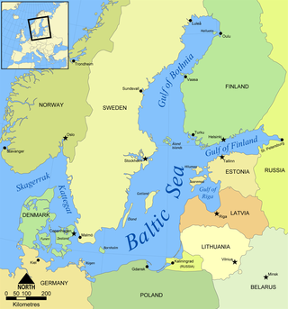
The Gulf of Bothnia is divided into the Bothnian Bay and Bothnian Sea, and it is the northernmost arm of the Baltic Sea, between Finland's west coast and Sweden's east coast. In the south of the gulf lies Åland, between the Sea of Åland and the Archipelago Sea.

A drainage basin is an area of land where all flowing surface water converges to a single point, such as a river mouth, or flows into another body of water, such as a lake or ocean. A basin is separated from adjacent basins by a perimeter, the drainage divide, made up of a succession of elevated features, such as ridges and hills. A basin may consist of smaller basins that merge at river confluences, forming a hierarchical pattern.
The Atlantic seaboard watershed is a watershed of the Atlantic Ocean in eastern North America along the Atlantic Canada (Maritimes) coast south of the Gulf of Saint Lawrence Watershed, and the East Coast of the United States north of the Kissimmee River watershed of Lake Okeechobee basin in the central Florida Peninsula.
The Eastern Continental Divide, Eastern Divide or Appalachian Divide is a hydrological divide in eastern North America that separates the easterly Atlantic Seaboard watershed from the westerly Gulf of Mexico watershed. The divide nearly spans the United States from south of Lake Ontario through the Florida peninsula, and consists of raised terrain including the Appalachian Mountains to the north, the southern Piedmont Plateau and lowland ridges in the Atlantic Coastal Plain to the south. Water including rainfall and snowfall, lakes, streams and rivers on the eastern/southern side of the divide drains to the Atlantic Ocean; water on the western/northern side of the divide drains to the Gulf of Mexico. The ECD is one of six continental hydrological divides of North America which define several drainage basins, each of which drains to a particular body of water.

A continental divide is a drainage divide on a continent such that the drainage basin on one side of the divide feeds into one ocean or sea, and the basin on the other side either feeds into a different ocean or sea, or else is endorheic, not connected to the open sea. Every continent on earth except Antarctica has at least one continental drainage divide; islands, even small ones like Killiniq Island on the Labrador Sea in Canada, may also host part of a continental divide or have their own island-spanning divide. The endpoints of a continental divide may be coastlines of gulfs, seas or oceans, the boundary of an endorheic basin, or another continental divide. One case, the Great Basin Divide, is a closed loop around an endoreic basin. The endpoints where a continental divide meets the coast are not always definite since the exact border between adjacent bodies of water is usually not clearly defined. The International Hydrographic Organization's publication Limits of Oceans and Seas defines exact boundaries of oceans, but it is not universally recognized. Where a continental divide meets an endorheic basin, such as the Great Divide Basin of Wyoming, the continental divide splits and encircles the basin. Where two divides intersect, they form a triple divide, or a tripoint, a junction where three watersheds meet.

Isojärvi is a medium-sized lake in Finland. It is situated in the region of Satakunta in Western Finland and in the municipalities of Pomarkku in south and Siikainen in north. The lake is a part of the Karvianjoki basin that drains into the Gulf of Bothnia.

Vehkajärvi is a medium-sized lake in Finland. It is located at the border of Pirkanmaa, Päijänne Tavastia and Central Finland regions in the Finnish Lakeland and there mostly in the municipality of Kangasala, and for lesser parts in the municipalities of Pälkäne, Padasjoki and Kuhmoinen.

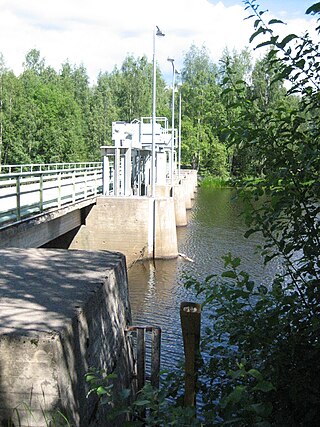
Vesijako is a lake in Finland. It is situated in Padasjoki in the region of Päijänne Tavastia.
Lummene is a lake in Finland in the municipality of Kuhmoinen in the Central Finland region.
Watersheds of North America are large drainage basins which drain to separate oceans, seas, gulfs, or endorheic basins. There are six generally recognized hydrological continental divides which divide the continent into seven principal drainage basins spanning three oceans and one endorheic basin. The basins are the Atlantic Seaboard basin, the Gulf of Mexico basin, the Great Lakes-St. Lawrence basin, the Pacific basin, the Arctic basin, the Hudson Bay basin, and the Great Basin. Together, the principal basins span the continent with the exception of numerous smaller endorheic basins.
Inhottu (Inhottujärvi) is a rather small lake in the Karvianjoki main catchment area. It is located in the region of Satakunta in Finland. It is a bifurcation lake because there are two outlets on the lake: the waters flow into the Gulf of Bothnia through the river Eteläjoki in Pori and into lake Isojärvi through the river Pomarkunjoki.

Geikie River is a river in the northern part of the Canadian province of Saskatchewan. The river's source is Costigan Lake, which is near the uranium producing areas around the Key Lake mine in the Athabasca Basin. It flows in a north-easterly direction and flows into Wollaston Lake.

Bontecou Lake, also known as Tamarack Swamp, is a shallow, man-made bifurcation lake in the towns of Stanford and Washington, in Dutchess County, New York, less than 5 mi (8 km) from the Village of Millbrook. Bontecou Lake straddles the drainage divide between the Wappinger Creek watershed to the west and the Tenmile River. Published estimates of its area vary between 113 acres (46 ha) and 135 acres (55 ha), placing it among the largest lakes in Dutchess County. The lake and surrounding land were protected as a nature preserve in 2022.

Moose Jaw River is a river in the Canadian province of Saskatchewan. It is located in the southern part of the province in a region called the Prairie Pothole Region of North America, which extends throughout three Canadian provinces and five U.S. states. It is also within Palliser's Triangle and the Great Plains ecoregion.
![]() Media related to Bifurcation lakes at Wikimedia Commons
Media related to Bifurcation lakes at Wikimedia Commons