
Gloucester County is a county in the U.S. state of New Jersey. As of the 2020 census, the county was the state's 14th-most populous county with a population of 302,294, its highest decennial count ever and an increase of 14,006 (+4.9%) from the 288,288 counted in the 2010 census, which in turn represented an increase of 33,615 (+13.2%) from the 2000 census population of 254,673. Its county seat is Woodbury.

Atlantic County is a county located along the Jersey Shore in the U.S. state of New Jersey. As of the 2020 census, the county was the state's 15th-most-populous county, with a population of 274,534, a drop of 15 from the 2010 census count of 274,549. Its county seat is the Mays Landing section of Hamilton Township. The county is part of the South Jersey region of the state.

Route 44 is a state highway located in Gloucester County in the U.S. state of New Jersey. It runs 10.28 mi (16.54 km) from Barker Avenue in Bridgeport to a cul-de-sac at a ramp from southbound Interstate 295 (I-295) and U.S. Route 130 in Thorofare. The route, which is mostly a two-lane undivided road, passes through the communities of Gibbstown and Paulsboro in the northern part of the county, a short distance south of the Delaware River. Route 44 generally runs a short distance to the north of I-295/US 130 for much of its length.

Mays Landing is an unincorporated community and census-designated place (CDP) located within Hamilton Township, Atlantic County, in the U.S. state of New Jersey. At the 2010 U.S. census, May's Landing's population was 2,135. It is the county seat of Atlantic County.
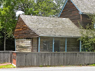
Gibbstown is an unincorporated community and census-designated place (CDP) located within Greenwich Township, in Gloucester County, in the U.S. state of New Jersey. As of the 2010 U.S. census, the CDP's population was 3,739. Gibbstown is the location of C. A. Nothnagle Log House, purportedly the oldest house in New Jersey and the oldest surviving log house in the U.S., dating to around 1638.
Greenwich Township is a township in Gloucester County, in the U.S. state of New Jersey. As of the 2020 United States census, the township's population was 4,917, an increase of 18 (+0.4%) from the 2010 census count of 4,899, which in turn reflected an increase of 20 (+0.4%) from the 4,879 counted in the 2000 census.

Paulsboro is a borough situated on the banks of the Delaware River within Gloucester County, in the U.S. state of New Jersey, within the Philadelphia metropolitan area. As of the 2020 United States census, the borough's population was 6,196, an increase of 99 (+1.6%) from the 6,097 recorded at the 2010 census, which in turn had reflected a decline of 63 (−1.0%) from the 6,160 counted at the 2000 census. Paulsboro and surrounding Gloucester County constitute part of South Jersey.

West Deptford Township is a township in Gloucester County, in the U.S. state of New Jersey. As of the 2020 United States census, the township's population was 22,197, an increase of 520 (+2.4%) from the 2010 census count of 21,677, which in turn reflected an increase of 2,309 (+11.9%) from the 19,368 counted in the 2000 census.
The Greenwich Township School District is a community public school district that serves students in kindergarten through eighth grade from Greenwich Township, Gloucester County, New Jersey, United States.
The Paulsboro Public Schools is a comprehensive community public school district that serves students in pre-kindergarten through twelfth grade from Paulsboro, in Gloucester County, New Jersey, United States.
Mount Royal is an unincorporated community and census-designated place located within East Greenwich Township in Gloucester County, in the U.S. state of New Jersey. The area is served as United States Postal Service ZIP Code 08061.

Mickleton is an unincorporated community and census-designated place located within East Greenwich Township in Gloucester County, in the U.S. state of New Jersey. The area is served as United States Postal Service ZIP Code 08056.
Paulsboro High School is a comprehensive community six-year public high school that serves students in seventh through twelfth grade from Paulsboro, in Gloucester County, in the U.S. state of New Jersey. It is the sole secondary school of the Paulsboro Public Schools.
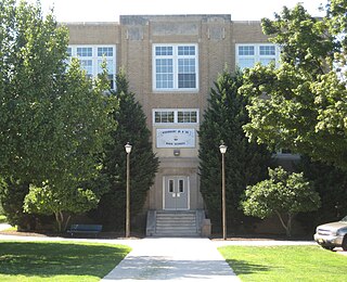
Woodbury Junior-Senior High School (WHS) is a comprehensive community middle school and public high school that serves students in sixth through twelfth grades from Woodbury, in Gloucester County, in the U.S. state of New Jersey, as part of the Woodbury Public Schools system. The class of 2003 was the school's 100th graduating class, making Woodbury High School one of the oldest secondary schools in South Jersey and the oldest in its athletic conference.
Franklinville is an unincorporated community and census-designated place (CDP) located within Franklin Township in Gloucester County, in the U.S. state of New Jersey. The area is served as United States Postal Service ZIP Code 08322.

Fort Billingsport, referred to as Fort Billings in some sources, was a Continental Army fort in Billingsport in Paulsboro, New Jersey in Gloucester County, New Jersey, during the American Revolutionary War. The site of the fort is now a public park of the same name, located at the Plains Terminal at the Port of Paulsboro between two oil refineries.
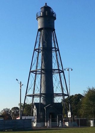
The Tinicum Island Rear Range Light is a lighthouse located in the Billingsport section of Paulsboro in Gloucester County, New Jersey, the rear of a pair of range lights marking a section of the channel in the Delaware River south of Philadelphia.

Route 44T, also known as the Gloucester County Tunnel, was a proposed state highway and vehicular tunnel during the 1930s from Gloucester County, New Jersey to Philadelphia County, Pennsylvania. The route was to begin at the state line near Paulsboro, New Jersey, heading eastward as a freeway through several southern New Jersey communities and providing access from New Jersey Route 42 to the Delaware River.
Wind power in New Jersey is in the early stages of development. New Jersey has just six wind turbines, but the state has plans to develop several major offshore wind projects on the continental shelf of the Atlantic Ocean off the southern Jersey Shore. Legislation has been enacted to support the industry through economic incentives and to permit wind turbines on existing piers.
The Port of Paulsboro is located on the Delaware River and Mantua Creek in and around Paulsboro, in Gloucester County, New Jersey, approximately 78 miles (126 km) from the Atlantic Ocean. Traditionally one of the nation's busiest for marine transfer operations, notably for crude oil and petroleum products, such as jet fuel and asphalt, it is a port of entry with several facilities within a foreign trade zone.


