
Salem County is a county located in the U.S. state of New Jersey. Its western boundary is formed by the Delaware River and it has the eastern terminus of the Delaware Memorial Bridge, connecting to New Castle, Delaware. Its county seat is Salem. The county is part of the Delaware Valley area. As of the 2017 Census estimate, the county's population was 62,607, making it the state's least populous county, representing a 5.1% decrease from the 66,083 enumerated at the 2010 Census, in turn increasing by 1,798 (+2.8%) from the 64,285 counted in the 2000 Census, retaining its position as the state's least populous county. The most populous place was Pennsville Township, with 13,409 residents at the time of the 2010 Census. Lower Alloways Creek Township covers 72.46 square miles (187.7 km2), the largest total area of any municipality.

Gloucester County is a county located in the U.S. state of New Jersey. As of the 2017 Census estimate, the county's population was 292,206, making it the state's 14th-most populous county, an increase of 1.4% from the 2010 United States Census, when its population was enumerated at 288,288, in turn an increase of 33,615 (+13.2%) from the 254,673 counted in the 2000 U.S. Census. The percentage increase in the county's population between 2000 and 2010 was the largest in New Jersey, almost triple the statewide increase of 4.5%, and the absolute increase in residents was the third highest. Its county seat is Woodbury.
Route 45 is a state highway in the southern part of New Jersey, United States. It runs 28.51 mi (45.88 km) from Route 49 in Salem, Salem County, northeast to U.S. Route 130 in Westville, Gloucester County. Much of the southern part of the route runs through rural areas of Salem and Gloucester counties, passing through the communities of Woodstown and Mullica Hill. North of Mullica Hill, Route 45 runs through suburban areas, with the portion of the route between the northern border of Mantua Township and the southern border of Woodbury a four-lane divided highway. The route intersects many highways, including US 40 in Woodstown, Route 77 and US 322 in Mullica Hill, and Interstate 295 (I-295) in West Deptford Township.

East Greenwich Township is a township in Gloucester County, New Jersey, United States. As of the 2010 United States Census, the township's population was 9,555, reflecting an increase of 4,125 (+76.0%) from the 5,430 counted in the 2000 Census, which had in turn increased by 172 (+3.3%) from the 5,258 counted in the 1990 Census.

Harrison Township is a township in Gloucester County, New Jersey, United States. As of the 2010 United States Census, the township's population was 12,417, reflecting an increase of 3,629 (+41.3%) from the 8,788 counted in the 2000 Census, which had in turn increased by 4,073 (+86.4%) from the 4,715 counted in the 1990 Census.

Logan Township is a township in Gloucester County, New Jersey, United States. As of the 2010 United States Census, the township's population was 6,042, reflecting an increase of 10 (+0.2%) from the 6,032 counted in the 2000 Census, which had in turn increased by 885 (+17.2%) from the 5,147 counted in the 1990 Census.

South Harrison Township is a township in Gloucester County, New Jersey, United States. As of the 2010 United States Census, the township's population was 3,162, reflecting an increase of 745 (+30.8%) from the 2,417 counted in the 2000 Census, which had in turn increased by 498 (+26.0%) from the 1,919 counted in the 1990 Census.

Swedesboro is a borough in Gloucester County, New Jersey, United States. As of the 2010 United States Census, the borough's population was 2,584, reflecting an increase of 529 (+25.7%) from the 2,055 counted in the 2000 Census, which had in turn increased by 31 (+1.5%) from the 2,024 counted in the 1990 Census.

Woolwich Township is a township in Gloucester County, New Jersey, United States. As of the 2010 United States Census, the township's population was 10,200, reflecting an increase of 7,168 (+236.4%) from the 3,032 counted in the 2000 Census, which had in turn increased by 1,573 (+107.8%) from the 1,459 counted in the 1990 Census.

Upper Pittsgrove Township is a township in Salem County, New Jersey, United States. As of the 2010 United States Census, the township's population was 3,505, reflecting an increase of 37 (+1.1%) from the 3,468 counted in the 2000 Census, which had in turn increased by 328 (+10.4%) from the 3,140 counted in the 1990 Census.
Route 77 is a state highway in the southern part of the U.S. state of New Jersey. It runs 22.55 mi (36.29 km) from an intersection with Route 49 in Bridgeton, Cumberland County north to a junction with Route 45 in Mullica Hill, Gloucester County. It is a mostly two-lane, undivided road traversing through farmland in Cumberland, Salem, and Gloucester Counties. Along the way, Route 77 intersects Route 56 in Upper Deerfield Township and U.S. Route 40 in Upper Pittsgrove Township.

South Jersey comprises the southern portion of the U.S. state of New Jersey, between the lower Delaware River and the Atlantic Ocean. The designation of southern New Jersey with a distinct toponym is a colloquial one rather than an administrative one, reflecting not only geographical but also perceived cultural differences from the northern part of the state, with no official definition. Though definitions of South Jersey may vary, most of South Jersey is generally considered to be part of the Philadelphia Metropolitan Area.
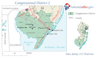
New Jersey's second congressional district, based in Southern New Jersey, is represented by Republican Jeff Van Drew. He was first elected as a Democrat in 2018, but announced on December 19, 2019 that he would be switching parties.

Whitehouse is an unincorporated community located within Readington Township in Hunterdon County, New Jersey, United States. The community lies along the Jersey Turnpike, just west of Mechanicsville.
Mantua Creek is a tributary of the Delaware River in Mantua Township, Gloucester County, New Jersey in the United States.

New Jersey's 3rd Legislative District is one of 40 in the state. As of the 2011 apportionment the district covers the Cumberland County municipalities of Bridgeton, Deerfield Township and Upper Deerfield Township; the Gloucester County municipalities of Clayton, East Greenwich Township, Elk Township, Franklin Township, Glassboro, Greenwich Township, Logan Township, National Park, Newfield, Paulsboro, South Harrison Township, Swedesboro, West Deptford Township, Woodbury Heights and Woolwich Township; and all Salem County municipalities, including Alloway Township, Carneys Point Township, Elmer, Elsinboro Township, Lower Alloways Creek Township, Mannington Township, Oldmans Township, Penns Grove, Pennsville Township, Pilesgrove Township, Pittsgrove Township, Quinton Township, Salem, Upper Pittsgrove Township and Woodstown.

Wagonhouse Winery is a winery in South Harrison Township in Gloucester County, New Jersey. Wagonhouse's original vineyard was first planted in 2004 in Mickleton, also in Gloucester County. The winery began sales of its wine in 2005, and opened a tasting room in South Harrison in 2011. Wagonhouse has 10 acres of grapes under cultivation, and produces 7,000 cases of wine per year. The winery is named for an old wagon house that is on their farm.


