
Walsall is a market town and administrative centre of the borough of the same name in the West Midlands, England. Historically part of Staffordshire, it is located 9 miles (14 km) northwest of Birmingham, 7 miles (11 km) east of Wolverhampton and 9 miles (14 km) southwest of Lichfield.

West Bromwich, commonly known as West Brom, is a market town in the borough of Sandwell, in the county of the West Midlands, England. Historically part of Staffordshire, it is 7 miles northwest of Birmingham. West Bromwich is part of the area known as the Black Country, in terms of geography, cultures and dialect. West Bromwich had a population of 103,112 in the 2021 Census.

Wednesbury is a market town in the Sandwell district, in the county of the West Midlands, England - historically in Staffordshire. It is located near the source of the River Tame, and is part of the Black Country. Wednesbury is situated 5 miles (8km) south-east of Wolverhampton, 3 miles (4.4km) south-west of Walsall, and 7 miles (11.8km) north-west of Birmingham. At the 2021 Census, the town's built-up area had a population of 20.313.
Sandwell is a metropolitan borough of the West Midlands county in England. The borough is named after the Sandwell Priory, and spans a densely populated part of the West Midlands conurbation. Sandwell Metropolitan Borough Council defines the borough as the six amalgamated towns of Oldbury, Rowley Regis, Smethwick, Tipton, Wednesbury and West Bromwich. Rowley Regis includes the towns of Blackheath and Cradley Heath.

Aldridge is a town in the Metropolitan Borough of Walsall in the West Midlands, England. It is historically, a village that was part of Staffordshire until 1974. The town is 3 miles (4.8 km) from Brownhills, 5 miles (8 km) from Walsall, 6 miles (9.7 km) from Sutton Coldfield and 7 miles (11 km) from Lichfield. The town is also the second-largest town in the Walsall Borough.
Bilston is a market town in the City of Wolverhampton in the West Midlands, England. It is close to the borders of Sandwell and Walsall. The nearest towns are Darlaston, Wednesbury, and Willenhall. Historically in Staffordshire, three wards of Wolverhampton City Council now cover the town: Bilston East and Bilston North, which almost entirely comprise parts of the historic Borough of Bilston, and Ettingshall, which comprises a part of Bilston and parts of Wolverhampton. The town had a population 34,639 at the 2021 Census.

Willenhall is a market town in the Walsall district, in the county of the West Midlands, England, with a population taken at the 2021 Census of 49,587. It is situated between Wolverhampton and Walsall, historically in the county of Staffordshire. It lies upon the River Tame, and is contiguous with both Wolverhampton and parts of South Staffordshire. The M6 motorway at Junction 10 separates it from Walsall.

Brownhills is a historic market and industrial town in the Metropolitan Borough of Walsall of the West Midlands, England. The town is located south of Cannock Chase and close to the large Chasewater reservoir, it is 6 miles (9.7 km) northeast of Walsall, a similar distance southwest of Lichfield and 13 miles (20.9 km) miles north-northwest of Birmingham. It is part of the Aldridge-Brownhills parliamentary constituency and neighbours the village of Pelsall and the suburban area of Walsall Wood. It lies within the boundaries of the historic county of Staffordshire.

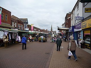
Bloxwich is a market town and civil parish in the Metropolitan Borough of Walsall, West Midlands, England. It is located between the towns of Walsall, Cannock, Willenhall and Brownhills.

Darlaston is an industrial and market town in the Metropolitan Borough of Walsall in the West Midlands of England. It is located near Bilston, Walsall, Wednesbury, West Bromwich, Willenhall and Wolverhampton. It was historically part of Staffordshire.

Leamore is a suburb of Bloxwich and Walsall in Metropolitan Borough of Walsall, West Midlands county, England. It is a mix of private and council housing built since the late 19th century. The most significant homes in the area are several multi-storey blocks of council flats, which were built in the 1960s.

Coseley is a village in the Dudley district, in the county of the West Midlands, England. It is situated three miles north of Dudley itself, on the border with Wolverhampton and Sandwell. It falls within the Tipton and Wednesbury parliamentary constituency.
Princes End is an area of Tipton, West Midlands, England, near the border with Coseley, which was heavily developed during the 19th century with the construction of factories. The population of the Sandwell ward taken at the 2011 census was 12,981. Several hundred terraced houses were built around the same time to accommodate the factory workers. Many council houses were built in the area between 1920 and 1980, as well as many private houses.

Walsall North was a constituency in the West Midlands represented in the House of Commons of the UK Parliament, created in 1955.
Walsall Metropolitan Borough Council elections are held three years out of every four, with a third of the council elected each time. Walsall Metropolitan Borough Council, which styles itself "Walsall Council", is the local authority for the metropolitan district of Walsall in the West Midlands, England. Since the last boundary changes in 2004, 60 councillors have been elected from 20 wards.

Rushall is a historic village and suburb in the Metropolitan Borough of Walsall in the West Midlands county of England. It is centred on the main road between Walsall and Lichfield. It is mentioned in the Domesday Book but has mostly developed since the 1920s. Rushall was historically a part of the county of Staffordshire before it was incorporated with much of the old Aldridge-Brownhills Urban District into the modern-day Walsall district.
North Walsall railway station was a station built by the Wolverhampton and Walsall Railway in 1872, and was operated by the Midland Railway from 1876 onwards. It served the north Walsall areas of Birchills and Leamore. It was located west of Bloxwich Road in a cutting.

Short Heath is a residential area situated north of the market town of Willenhall, in the Walsall district, in the county of the West Midlands, England. Short Heath is a ward in the Walsall North constituency, and is bordered by the neighbouring wards of Bentley and Darlaston North, Birchills Leamore, Willenhall North, and Willenhall South.

Walsall Council, formally Walsall Metropolitan Borough Council, is the local authority for the Metropolitan Borough of Walsall in the West Midlands, England. The town of Walsall had been a borough from medieval times, which was reformed on numerous occasions. Since 1974 the council has been a metropolitan borough council. It provides the majority of local government services in the borough. The council has been a member of the West Midlands Combined Authority since 2016.

Walsall and Bloxwich is a constituency of the House of Commons in the UK Parliament. Further to the completion of the 2023 Periodic Review of Westminster constituencies, it was first contested at the 2024 general election. The constituency is currently held by Valerie Vaz of the Labour Party, who held the previous Walsall South constituency prior to the boundary changes.

