
The Black Rock Desert is a semi-arid region of lava beds and playa, or alkali flats, situated in the Black Rock Desert–High Rock Canyon Emigrant Trails National Conservation Area, a silt playa 100 miles (160 km) north of Reno, Nevada that encompasses more than 300,000 acres (120,000 ha) of land and contains more than 120 miles (200 km) of historic trails. It is in the northern Nevada section of the Great Basin with a lakebed that is a dry remnant of Pleistocene Lake Lahontan.

Caesar Creek State Park is a public recreation area located in southwestern Ohio, five miles (8 km) east of Waynesville, in Warren, Clinton, and Greene counties. The park is leased by the State from the U.S. Army Corps of Engineers, who in the 1970s erected a dam on Caesar Creek to impound a 2,830-acre (1,150 ha) lake. The total park area, including the lake, is 7,530-acre (3,050 ha).

Adams Township is one of twelve townships in Warren County, Indiana. According to the 2010 census, its population was 512 and it contained 250 housing units.

Shades State Park is a state park in Montgomery, Parke, and Fountain Counties in Indiana. It is located 47 miles (76 km) west-northwest of Indianapolis, Indiana. In 2018–2019, Shades received nearly 87,000 visitors.
Kent Township is one of twelve townships in Warren County, Indiana, United States. According to the 2010 census, its population was 428 and it contained 196 housing units.
Liberty Township is one of twelve townships in Warren County, Indiana, United States. According to the 2010 census, its population was 896 and it contained 362 housing units.

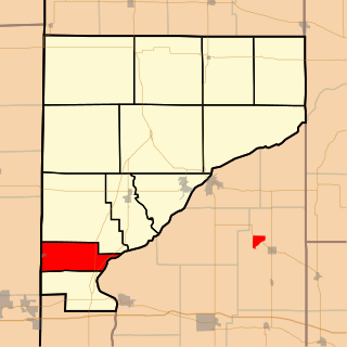
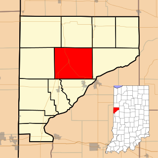
Mound Township is one of twelve townships in Warren County, Indiana, United States. According to the 2010 census, its population was 418 and it contained 183 housing units.

Pike Township is one of twelve townships in Warren County, Indiana, United States. According to the 2010 census, its population was 1,221 and it contained 529 housing units.

Pine Township is one of twelve townships in Warren County, Indiana, United States. According to the 2010 census, its population was 481 and it contained 213 housing units.

Warren Township is one of twelve townships in Warren County, Indiana, United States. According to the 2010 census, its population was 806 and it contained 324 housing units.

Washington Township is one of twelve townships in Warren County, Indiana, United States. It is the most populous township in the county; according to the 2010 census, its population was 2,298, with 1,898 of those living in Williamsport, and it contained 1,011 housing units. It has the highest population density of the Warren County townships at about 120 inhabitants per square mile (46/km2).
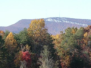
Keel Mountain is a mesa in Madison and Jackson Counties in Alabama. It is associated with the Cumberland Plateau, which it is separated from by the valley of the Paint Rock River. It is named for early pioneers Jesse and Priscilla (Whitaker) Keel, who settled there from North Carolina prior to 1810.
The Sauratown Mountains, which are sometimes called "the mountains away from the mountains", are an isolated mountain range located within Stokes and Surry counties in the U.S. state of North Carolina. The vast majority of the range is located in Stokes County. Although the range occupies only 5% of Stokes County's area, it dominates the county's scenery from almost every direction. The Sauras rise sharply 800 to 1,700 feet above the surrounding terrain.

The Galien River is a 30.0-mile-long (48.3 km) stream in the southwest region of the U.S. state of Michigan. The river begins at the outlet of Dayton Lake and flows in a predominantly westerly direction until it enters southeastern Lake Michigan at New Buffalo. The South Branch Galien River rises just north of the border with Indiana, at the confluence of Spring Creek and the Galena River, the latter rising in LaPorte County, Indiana.

Logan Township is one of eleven townships in Fountain County, Indiana, United States. As of the 2010 census, its population was 3,672 and it contained 1,685 housing units.

Black Mesa State Park is an Oklahoma state park in Cimarron County, near the western border of the Oklahoma panhandle and New Mexico. The park is located about 15 miles (24 km) away from its namesake, Black Mesa, the highest point in Oklahoma. The mesa was named for the layer of black lava rock that coats it.
Bluerock Mountain is a mountain in Western North Carolina, near the community of Bat Cave. It is split between Henderson and Rutherford counties, it is home of the Bat Cave Preserve and part of Chimney Rock State Park. Its elevation reaches 2,835 feet (864 m).
Beanblossom Creek is a stream in Monroe and Brown counties, Indiana, in the United States. The creek drains roughly 91.97 square miles into the two counties of south central Indiana.
Romine Corner is an extinct town that was located in Mound Township in Warren County, Indiana, west of the town of Covington.
Old Town is an extinct town located in Pike Township in Warren County, Indiana, and the original site of what is now the town of West Lebanon.


