Blackbull Queensland | |||||||||||||||
---|---|---|---|---|---|---|---|---|---|---|---|---|---|---|---|
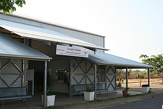
The Gulflander stopped at Blackbull siding, 2013 | |||||||||||||||
Coordinates | 17°48′21″S141°44′41″E / 17.8057°S 141.7447°E Coordinates: 17°48′21″S141°44′41″E / 17.8057°S 141.7447°E | ||||||||||||||
Postcode(s) | 4871 | ||||||||||||||
Area | 3,471.8 km2 (1,340.5 sq mi) | ||||||||||||||
LGA(s) | Shire of Croydon | ||||||||||||||
State electorate(s) | Traeger | ||||||||||||||
Federal Division(s) | Kennedy | ||||||||||||||
|
Blackbull is a locality in the Shire of Croydon, Queensland, Australia. [1]
Suburbs and localities are the names of geographic subdivisions in Australia, used mainly for address purposes. The term locality is used in rural areas, while the term suburb is used in urban areas. Australian postcodes closely align with the boundaries of localities and suburbs.
The Shire of Croydon is a local government area in western Queensland, Australia. The shire, administered from the town of Croydon, covers an area of 29,577.8 square kilometres (11,420.1 sq mi). The council consists of a mayor plus four councillors, each of whom represents the entire Shire.
Queensland is the second-largest and third-most populous state in the Commonwealth of Australia. Situated in the north-east of the country, it is bordered by the Northern Territory, South Australia and New South Wales to the west, south-west and south respectively. To the east, Queensland is bordered by the Coral Sea and Pacific Ocean. To its north is the Torres Strait, with Papua New Guinea located less than 200 km across it from the mainland. The state is the world's sixth-largest sub-national entity, with an area of 1,852,642 square kilometres (715,309 sq mi).
The Gulf Developmental Road passes through the locality from the south-east to the south-west. The Normanton to Croydon railway line runs immediately parallel to it with the locality being served by the Blackbull railway siding. [2] The only service that operates on the railway line is the weekly Gulflander, which operates as a tourist attraction and includes a morning tea stop at the Blackbull railway siding. [3]
The Gulf Developmental Road links the Cairns and Normanton regions in northern Queensland, Australia. It is the only sealed (asphalt) road linking these two regions.
The Normanton to Croydon railway line is a heritage-listed railway line in the Gulf Country of northern Queensland, Australia. The railway line linking Normanton in the Shire of Carpentaria to Croydon in the Shire of Croydon was built between 1888 and 1891 and is the last isolated line of Queensland Rail still in use. It utilises an innovative system of submersible track with patented steel sleepers and retains buildings of considerable architectural and technical interest at its terminus in Normanton. The only train to operate on the line is the weekly Gulflander service operated by a Gardner diesel propelled railmotor and carriages TP1809 and TP1811.
The Gulflander is an passenger train operated by Queensland Rail on the isolated Normanton to Croydon line in the Gulf Country of northern Queensland, Australia.
The Carron River "flows" through the locality from south-east to north-west, although in the dry season it is just a string of waterholes. It is a tributary of the Norman River which flows into the Gulf of Carpentaria. [2]
The Carron River is a river located in Far North Queensland, Australia.
The Norman River is a river in the Gulf Country, Queensland, Australia. The river originates in the Gregory Range 200 km southeast of Croydon, Queensland and flows 420 km northwest to the Gulf of Carpentaria. It is joined by three major tributaries, the Carron, Clara and Yappar Rivers. The river flows through Normanton before entering the Gulf of Carpentaria through the major fishing port of Karumba. The mouth of the river lies in the Gulf Plains Important Bird Area.
The Gulf of Carpentaria is a large, shallow sea enclosed on three sides by northern Australia and bounded on the north by the eastern Arafura Sea. The northern boundary is generally defined as a line from Slade Point, Queensland in the northeast, to Cape Arnhem, Northern Territory in the west.
The locality takes its name from the Blackbull railway siding on Normanton to Croydon railway line. [1] The railway siding was originally called Pattersons siding, but was renamed in 1891, reportedly after a black bull found during mustering by William and Joseph Taaffe. [4]
Normanton is a small cattle town and coastal locality in the Shire of Carpentaria in Queensland, Australia. In the 2016 census, Normanton had a population of 1,210 people of whom 743 were Indigenous Australians.
Croydon is a town and locality within the Shire of Croydon in Queensland, Australia. At the 2011 census, the town and surrounding area recorded a population of 312 people. It is a terminus for the Normanton to Croydon railway line, which operates the Gulflander tourist train.
Richmond is a town and locality in the Shire of Richmond in western Queensland, Australia. It is the administrative centre of the Richmond Shire. In the 2011 census, Richmond had a population of 522 people.
Cooran is a small hinterland town and locality in the Shire of Noosa in Queensland, Australia. Between 2008 and 2013 it was within Sunshine Coast Region. In the 2011 census, Cooran had a population of 1,457 people.
Thallon is a town and a locality in the Shire of Balonne, Queensland, Australia. In the 2016 census, Thallon had a population of 257 people.
Duchess is a town and a locality in the Shire of Cloncurry, Queensland, Australia.
Minnamoolka is a locality in the Tablelands Region, Queensland, Australia. In the 2016 census, Minnamoolka had a population of 38 people.
George Phillips was a surveyor, and member of the Queensland Legislative Assembly in Australia.
Croydon railway station is a heritage-listed railway station at Helen Street, Croydon, Shire of Croydon, Queensland, Australia. It was built from c. 1888 to c. 1891. It is on the Normanton to Croydon railway line. It was added to the Queensland Heritage Register on 21 October 1992.
Burns Philp Building is a heritage-listed former warehouse at the corner of Landsborough Street and Caroline Street, Normanton, Shire of Carpentaria, Queensland, Australia. It was built by Andrew Murphy. It was added to the Queensland Heritage Register on 14 October 2011.
Bungunya is a town and locality in the Goondiwindi Region, Queensland, Australia. In the 2011 census, Bungunya had a population of 189 people.
Conjuboy is a remote locality in the Shire of Etheridge, Queensland, Australia.
Biboohra is a town and a locality in the Shire of Mareeba, Queensland, Australia.
Stokes is a locality in the Shire of Carpentaria, Queensland, Australia. In the 2016 census, Stokes had a population of 84 people.
Carpentaria is a coastal locality in the Shire of Carpentaria, Queensland, Australia. In the 2016 census, Carpentaria had a population of 14 people.
Howitt is a coastal locality in the Shire of Carpentaria, Queensland, Australia. In the 2016 census, Howitt had a population of 24 people.
Fielding is a locality in the Shire of Carpentaria, Queensland, Australia. In the 2016 census, Fielding had a population of 6 people.
Karron is a locality in the Shire of Croydon, Queensland, Australia. In the 2016 census, Karron had a population of 0 people.