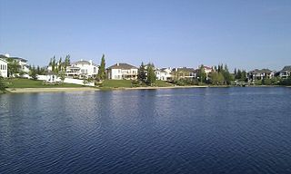
Blackmud Creek, Edmonton

Last updated
Blackmud Creek
Neighbourhood
Edmonton agglomeration-blank.svg
Red pog.svg
Blackmud Creek
Location of Blackmud Creek in Edmonton
Coordinates: 53°25′12″N113°30′43″W / 53.420°N 113.512°W / 53.420; -113.512
CountryFlag of Canada (Pantone).svg  Canada
Province Flag of Alberta.svg  Alberta
City Edmonton
Quadrant [1] SW
Ward [1] Ipiihkoohkanipiaohtsi
Sector [2] Southwest
Area [3] [4] Heritage Valley
Government
[5]
  Administrative body Edmonton City Council
  CouncillorJennifer Rice
Area
[6]
  Total0.78 km2 (0.30 sq mi)
Elevation
689 m (2,260 ft)
Population
 (2012) [7]
  Total2,577
  Density3,303.8/km2 (8,557/sq mi)
  Change (2009–12)
Increase2.svg0.6%
  Dwellings
942

Blackmud Creek is a new residential neighbourhood in south west Edmonton, Alberta, Canada.

Contents

The neighbourhood is bounded on the west by the James Mowat Trail (111 Street), and on the north by Ellerslie Road. To the east and south, the neighbourhood overlooks the Blackmud Creek Ravine.

The community is represented by the Blackmud Creek Community League, established in 2006, which unlike many other community leagues in Edmonton, does not maintain a community hall of its own. [8] [9]

Demographics

In the City of Edmonton's 2012 municipal census, Blackmud Creek had a population of 2,577 living in 942 dwellings, [7] a 0.6% change from its 2009 population of 2,561. [10] With a land area of 0.78 km2 (0.30 sq mi), [6] it had a population density of 3,303.8 people/km2 in 2012. [7] [6] >

Residential development

Blackmud Creek is a neighbourhood that developed after the 2001 federal census.

According to the 2005 municipal census, the most common type or residence in the neighbourhood is the single-family dwelling. These account for nine out of every ten (88%) residences in the neighbourhood. The remaining residences are duplexes [11] (7%) and apartment style condominiums in low-rise buildings with fewer than five stories. Substantially all (96%) residences in the neighbourhood are owner-occupied. [12]

Surrounding neighbourhoods

See also

Related Research Articles

<span class="mw-page-title-main">Twin Brooks, Edmonton</span> Neighbourhood in Edmonton, Alberta, Canada

Twin Brooks is a residential neighbourhood in south Edmonton, Alberta, Canada. It is located at the confluence of the Whitemud Creek and the Blackmud Creek, hence the origin of the name Twin Brooks. An artificial lake is situated in the neighbourhood, with George P. Nicholson Elementary School located near it.

Minchau is a residential neighbourhood in the Mill Woods area of Edmonton, Alberta, Canada. It is named for August Minchau, a Prussian immigrant who settled in the Mill Woods area in the late 19th century.

Sherwood is a small neighbourhood in west Edmonton, Alberta, Canada. Originally part of the Town of Jasper Place, it became a part of Edmonton when Jasper Place amalgamated with Edmonton in 1964.

Ellerslie is a residential neighbourhood in southeast Edmonton, Alberta, Canada. While City of Edmonton documents note that there are diverse stories related to Scottish settlers introducing the name Ellerslie, it is known that the name was applied to the local school district by 1895, and to the local post office in 1896, when it was still a rural area many kilometers south of the early boundaries of the recently (1892) incorporated Town of Edmonton.

Elmwood Park is a neighbourhood in north central Edmonton, Alberta, Canada.

Rutherford is a neighbourhood in south Edmonton, Alberta, Canada. It is named after Alexander Cameron Rutherford, Alberta's first premier.

Kenilworth is a residential neighbourhood in south east Edmonton, Alberta, Canada located just to the north of Whyte Avenue.

Terrace Heights is a roughly triangle-shaped residential neighbourhood in south east Edmonton, Alberta, Canada.

Allendale is a residential neighbourhood located in south west Edmonton, Alberta, Canada. The neighbourhood is named for the Allen family, who owned a farm there. It was annexed by the City of Strathcona in 1907.

Hazeldean is a residential neighbourhood in south east Edmonton, Alberta, Canada. The neighbourhood overlooks the Mill Creek Ravine.

Skyrattler is a residential neighbourhood in south west Edmonton, Alberta, Canada. The neighbourhood is named after Chief Skyrattler of the Winterburn band.

Bearspaw, a residential neighbourhood located in southwest Edmonton, Alberta, Canada, is named after the Stony Indian Chief Masgwaahisd (Bearspaw). It is located close to the shopping and services located in Century Park, Gateway Boulevard, and South Edmonton Common.

Blue Quill is a residential neighbourhood located in south west Edmonton, Alberta, Canada. Blue Quill and the adjacent neighbourhood of Blue Quill Estates are named to honour Chief Blue Quill of the Saddle Lake Band.

Fulton Place is a residential neighbourhood in east Edmonton, Alberta, Canada. It is named for the creek which runs along the neighbourhood's west boundary. It is part of a broader area of surrounding communities known as Greater Hardisty.

Rosslyn is a residential neighbourhood in north west Edmonton, Alberta, Canada. The neighbourhood has good access to shopping services at Northgate Centre and North Town Mall.

Richford is a newer neighbourhood in south west Edmonton, Alberta, Canada overlooking the Blackmud Creek Ravine. According to the 2005 municipal census, there were 161 residences in the neighbourhood.

<span class="mw-page-title-main">Queen Alexandra, Edmonton</span> Neighbourhood in Edmonton, Alberta, Canada

Queen Alexandra is a mixed residential and commercial neighbourhood in south west Edmonton, Alberta, Canada. The neighbourhood, once part of the City of Strathcona, is named for Alexandra of Denmark. The north edge of the neighbourhood, along Whyte Avenue is part of Old Strathcona, a popular commercial and cultural area of Edmonton.

Blackburne is a neighbourhood in southwest Edmonton, Alberta, Canada. It is an irregularly shaped neighbourhood whose southwest boundary overlooks the Blackmud Creek Ravine. It is bounded by Anthony Henday Drive to the north and by Calgary Trail to the east. A small portion of the neighbourhood extends across Blackmud Creek to 111 Street in the west.

Hodgson is a newer residential neighbourhood located in south west Edmonton, Alberta, Canada, with all residential development occurring after 2001.

Ogilvie Ridge is a residential neighbourhood in south west Edmonton, Alberta, Canada overlooking the Whitemud Creek ravine. It is bounded by the ravine to the east and north. On the west the neighbourhood is bounded by Rabbit Hill Road and on the south by a utility corridor located just north of 29 Avenue.

References

  1. 1 2 "City of Edmonton Wards & Standard Neighbourhoods" (PDF). City of Edmonton. Archived from the original (PDF) on May 3, 2014. Retrieved February 13, 2013.
  2. "Edmonton Developing and Planned Neighbourhoods, 2011" (PDF). City of Edmonton. Archived from the original (PDF) on September 4, 2013. Retrieved February 13, 2013.
  3. "The Way We Grow: Municipal Development Plan Bylaw 15100" (PDF). City of Edmonton. 2010-05-26. Archived from the original (PDF) on May 2, 2015. Retrieved February 13, 2013.
  4. "City of Edmonton Plans in Effect" (PDF). City of Edmonton. November 2011. Archived from the original (PDF) on October 17, 2013. Retrieved February 13, 2013.
  5. "City Councillors". City of Edmonton. Retrieved February 13, 2013.
  6. 1 2 3 "Neighbourhoods (data plus kml file)". City of Edmonton. Retrieved February 13, 2013.
  7. 1 2 3 "Municipal Census Results – Edmonton 2012 Census". City of Edmonton. Retrieved February 22, 2013.
  8. "Blackmud Creek Community League". Blackmud Creek Community League. Retrieved October 7, 2017.
  9. "Find a Facility/League". Edmonton Federation of Community Leagues. Retrieved October 7, 2017.
  10. "2009 Municipal Census Results". City of Edmonton. Retrieved February 22, 2013.
  11. Duplexes include triplexes and fourplexes.
  12. http://censusdocs.edmonton.ca/C05002/MUNICIPAL%202005/Neighbourhood/BLACKMUD%20CREEK.pdf [ bare URL PDF ]