| Blair Precinct | |
|---|---|
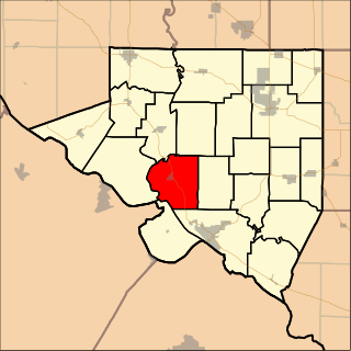
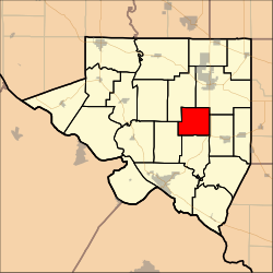 Location in Randolph County | |
| Coordinates: 38°02′39″N089°44′33″W / 38.04417°N 89.74250°W Coordinates: 38°02′39″N089°44′33″W / 38.04417°N 89.74250°W | |
| Country | United States |
| State | Illinois |
| County | Randolph |
| Area | |
| • Total | 17.52 sq mi (45.38 km2) |
| • Land | 17.44 sq mi (45.18 km2) |
| • Water | 0.08 sq mi (0.20 km2) 0.004% |
| Elevation | 512 ft (156 m) |
| Population (2000) | |
| • Total | 290 |
| • Density | 16.6/sq mi (6.42/km2) |
| GNIS feature ID | 1928447 [1] |
Blair Precinct was a district of Randolph County, Illinois, USA. As of the 2000 census, its population was 290. [2] As of the 2010 census, it had been split between Central Precinct and Palestine Precinct.

Randolph County is a county located in the U.S. state of Illinois. According to the 2010 census, it had a population of 33,476. Its county seat is Chester.

Illinois is a state in the Midwestern region of the United States. It has the 5th largest Gross Domestic Product by state, is the 6th-most populous U.S. state and 25th-largest state in terms of land area. Illinois is often noted as a microcosm of the entire United States. With Chicago in the northeast, small industrial cities and great agricultural productivity in northern and central Illinois, and natural resources such as coal, timber, and petroleum in the south, Illinois has a diverse economic base, and is a major transportation hub. Chicagoland, Chicago's metropolitan area, contains over 65% of the state's population. The Port of Chicago connects the state to other global ports around the world from the Great Lakes, via the Saint Lawrence Seaway, to the Atlantic Ocean; as well as the Great Lakes to the Mississippi River, via the Illinois Waterway on the Illinois River. The Mississippi River, the Ohio River, and the Wabash River form parts of the boundaries of Illinois. For decades, Chicago's O'Hare International Airport has been ranked as one of the world's busiest airports. Illinois has long had a reputation as a bellwether both in social and cultural terms and, through the 1980s, in politics.

The United States of America (USA), commonly known as the United States or America, is a country composed of 50 states, a federal district, five major self-governing territories, and various possessions. At 3.8 million square miles, the United States is the world's third or fourth largest country by total area and is slightly smaller than the entire continent of Europe's 3.9 million square miles. With a population of over 327 million people, the U.S. is the third most populous country. The capital is Washington, D.C., and the largest city by population is New York City. Forty-eight states and the capital's federal district are contiguous in North America between Canada and Mexico. The State of Alaska is in the northwest corner of North America, bordered by Canada to the east and across the Bering Strait from Russia to the west. The State of Hawaii is an archipelago in the mid-Pacific Ocean. The U.S. territories are scattered about the Pacific Ocean and the Caribbean Sea, stretching across nine official time zones. The extremely diverse geography, climate, and wildlife of the United States make it one of the world's 17 megadiverse countries.