
Adjuntas is a small mountainside town and municipality in Puerto Rico located central midwestern portion of the island on the Cordillera Central, north of Yauco, Guayanilla, and Peñuelas; southeast of Utuado; east of Lares and Yauco; and northwest of Ponce. Adjuntas is spread over 16 barrios and Adjuntas Pueblo. Adjuntas is about two hours by car westward from the capital, San Juan.

Utuado is a town and municipality of Puerto Rico located in the central mountainous region of the island known as the Cordillera Central. It is located north of Adjuntas and Ponce; south of Hatillo and Arecibo; east of Lares; and west of Ciales and Jayuya. It is the third-largest municipality in land area in Puerto Rico. According to the 2020 US Census, the municipality has a population of 28,287 spread over 24 barrios and Utuado pueblo.
This is a list of properties and historic districts that are listed on the National Register of Historic Places (NRHP) in Puerto Rico, not to be confused with the Puerto Rico Register of Historic Sites and Zones. There are more than 375 listings in Puerto Rico, with one or more listing in each of Puerto Rico's 78 municipalities.
The Viví River is a river in Puerto Rico that runs through the town of Utuado and Adjuntas, Puerto Rico. It is about 11 miles long.

Puerto Rico Highway 10 (PR-10) is a major highway in Puerto Rico. The primary state road connects the city of Ponce in the south coast to Arecibo in the north; it is also the shortest route between the two cities.

Puerto Rico Highway 123 (PR-123) is a secondary highway that connects the city Arecibo to the city of Ponce. It runs through the towns of Utuado and Adjuntas, before reaching Ponce. A parallel road is being built, PR-10, that is expected to take on most of the traffic currently using PR-123.

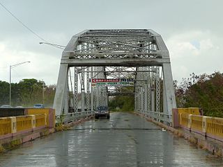
The Las Cabañas Bridge is a historic highway bridge in Adjuntas municipality, Puerto Rico. Built in 1919 to provide access to a key coffee-producing region, it was financed by nearby plantations through public subscription. Designer Rafael Nones and builder Félix Benítez Rexach, two of the most prominent figures in Puerto Rican bridge construction in the early 20th century, used a unique combination of steel and concrete technologies to produce a girder design unlike any other on the island and possibly beyond.

The Puente Blanco is a historic railway bridge that spans hundred and fifty feet deep and thirty six metres wide gorge across the Quebrada Mala Canyon, near Quebradillas, Puerto Rico. The bridge is the only reinforced concrete bridge in the area and the highest of its kind in Puerto Rico. It was built in 1922 by the American Railroad Company to replace a 1907 steel bridge as part of the construction of the national railway system that connected the island during the first half of the twentieth century. It was built on a concrete platform that held the existing steel bridge without interrupting the passage of the railway. The new bridge could hold two locomotives of 84 tons each. It was designed by Etienne Totti from Yauco who was the head engineer for the company. The bridge was restored by the municipality of Quebradillas, unfortunately as part of the repair the base was widened altering the character of the structure and hindering the view of the bridge. It was listed on the National Register of Historic Places in 1984 and on the Puerto Rico Register of Historic Sites and Zones in 2000.

The Arenas Bridge is a truss bridge built in 1894 between the municipalities of Cayey and Cidra in Puerto Rico. Also known as Puente Rio La Plata, it was the longest bridge constructed in Puerto Rico during the Spanish colonial period. It crosses the Rio de la Plata, the longest river in Puerto Rico. According to the U.S. National Park Service, "[t]his is the most important metal bridge in Puerto Rico from the period." The bridge is still standing.
The Carretera Central is a historic north–south central highway in Puerto Rico, linking the cities of San Juan and Ponce by way of Río Piedras, Caguas, Cayey, Aibonito, Coamo, and Juana Díaz. It crosses the Cordillera Central. Plans for the road started in the first half of the 19th century, and the road was fully completed in 1898. At the time the United States took possession of Puerto Rico in 1898, the Americans called it "the finest road in the Western Hemisphere."

This portion of National Register of Historic Places listings in Puerto Rico is along the central mountain region, from Las Marías and Maricao in the central-west to Juncos in the central-east, including the slopes of the Cordillera.
Porta Cordillera, or simply Central Region, is a land-locked tourism region located in the central mountainous area of Puerto Rico. Porta Cordillera was officially launched in July 2012 by the Puerto Rico Tourism Company. It consists of 16 municipalities: Aguas Buenas, Cidra, Cayey, Comerío, Aibonito, Naranjito, Barranquitas, Corozal, Orocovis, Morovis, Ciales, Jayuya, Florida, Utuado, Adjuntas and Lares.

The Puente de Trujillo Alto is a Pennsylvania through truss bridge built during 1939–1941 in Puerto Rico in the Trujillo Alto municipality of Puerto Rico. At was the longest single-span bridge in Puerto Rico.

The General Norzagaray Bridge is a brick and masonry barrel vault bridge built in 1855 in San Juan, Puerto Rico. Also known as Puente de los Frailes, it brings what is now Puerto Rico Highway 873 across Frailes Creek, a tributary to the Guaynabo River. It has eight 9.8-metre (32 ft) barrel vault spans. Its total length is 120.7 metres (396 ft) and its roadway width is 7.00 metres (22.97 ft). It was listed on the National Register of Historic Places (NRHP) in 1995, and on the Puerto Rico Register of Historic Sites and Zones in 2000.
The Puente de Añasco, also called Puente Salcedo, is a bridge spanning between Añasco, Puerto Rico and Mayagüez, Puerto Rico. It was listed on the National Register of Historic Places in 2011. It is located at Kilometer 146.1 of Highway 2.

Cambalache Bridge or Puente Francés is a bridge built in 1893 which spans the Río Grande de Arecibo from Cambalache barrio to Tanamá barrio in Arecibo. It is located 100 meters west of Puerto Rico Highway 2, at kilometer 72.

The Mavilla Bridge, or Bridge 354, is located at kilometer 17.7 on Puerto Rico Highway 159 between Corozal and Bayamón, Puerto Rico. The bridge has maintained most of its original design and structure over the years. It was constructed in 1903 replacing a wooden bridge that had been at the location since 1853, and served as a road between Toa Alta and Bayamón municipalities, in the 19th century.

Marqués de la Serna Bridge, also known as Bayamón Bridge and Bridge #379, is a historic rolled iron segmented arch bridge that crosses the Bayamón River, located between the barrios of Bayamón Pueblo and Juan Sánchez in the Puerto Rican municipality of Bayamón. Its lowered arches, similar to those of the Pont d'Arcole in Paris, are unique in Puerto Rico. The bridge was added to the United States National Register of Historic Places on July 19, 1995, and to the Puerto Rico Register of Historic Sites and Zones in 2000.
Padre Íñigo Bridge, also known as the Coamo Bridge or Bridge #174, is a historic lattice girder bridge that crosses the Coamo River in the municipality of the same name in southern Puerto Rico. It was added to the United States National Register of Historic Places in 1995, and to the Puerto Rico Register of Historic Sites and Zones in 2001.
The Prieto River Bridge, also known as Bridge #261 and better known as the "Del Treinta" Bridge, is a historic bridge located in the Indiera Alta barrio of the municipality of Maricao, Puerto Rico. It was built in 1924 as part of a highway construction boom that occurred in the island during the 1920s. The bridge spans across the Prieto River in the Luis Muñoz Marín Scenic Route and was added to the National Register of Historic Places in 1995 and to the Puerto Rico Register of Historic Sites and Zones in 2001.


