
The A69 is a major northern trunk road in England, running east–west across the Pennines, through the counties of Tyne and Wear, Northumberland and Cumbria. Originally, the road started in the centre of Newcastle upon Tyne then later near Birtley, but since the creation of the A1 Western Bypass around Newcastle upon Tyne, it now starts at Denton Burn, a suburb of Newcastle upon Tyne.

The Metropolitan Borough of Gateshead is a metropolitan borough in the metropolitan county of Tyne and Wear, North East England. It includes Gateshead, Rowlands Gill, Whickham, Blaydon, Ryton, Felling, Birtley, Pelaw, Dunston and Low Fell. The borough forms part of the Tyneside conurbation, centred on Newcastle upon Tyne.

The High Level Bridge is a road and railway bridge spanning the River Tyne between Newcastle upon Tyne and Gateshead in North East England. It is considered the most notable historical engineering work in the city. It was built by the Hawks family from 5,050 tons of iron. George Hawks, Mayor of Gateshead, drove in the last key of the structure on 7 June 1849, and the bridge was officially opened by Queen Victoria later that year.

Blaydon is a town in the Metropolitan Borough of Gateshead, Tyne and Wear, England, and historically in County Durham. Blaydon, and neighbouring Winlaton, which Blaydon is now contiguous with, form the postal town of Blaydon-on-Tyne. The Blaydon/Winlaton resident population in 2011 was 13,896.
Rowlands Gill is a town situated along the A694, between Winlaton Mill and Hamsterley Mill, on the north bank of the River Derwent, in the Metropolitan Borough of Gateshead, Tyne and Wear, England. Within Gateshead's greenbelt, the town has a picturesque setting with much open space and views across the valley to Gibside Estate, now owned by the National Trust.
"Blaydon Races" is a Geordie folk song, the words for which were written in the 19th century by Geordie Ridley, in a style deriving from music hall. Ridley's words were set to an existing American tune labelled "Brighton" in early publications of Ridley's song, which refers to an American song called "On the Road to Brighton". It is frequently sung by supporters of Newcastle United Football Club, Newcastle Falcons rugby club, and Durham County Cricket Club.

The Quayside is an area along the banks (quay) of the River Tyne in Newcastle upon Tyne and Gateshead in Tyne and Wear, North East England, United Kingdom.
The Redheugh Bridge is a road bridge spanning the River Tyne west of Newcastle upon Tyne city centre on the north bank and Gateshead town centre on the south bank, in North East England. It currently carries the A189 road.
Winlaton is a village situated in the Metropolitan Borough of Gateshead, Tyne and Wear. Once in County Durham, it became incorporated into the metropolitan county of Tyne and Wear and Borough of Gateshead in 1974. In 2011 the village was absorbed into the Gateshead MBC ward of Winlaton and High Spen. The population of this ward at the 2011 census was 8,342.

The Stella power stations were a pair of now-demolished coal-fired power stations in the North East of England that were a landmark in the Tyne valley for over 40 years. The stations stood on either side of a bend of the River Tyne: Stella South power station, the larger, near Blaydon in Gateshead, and Stella North power station near Lemington in Newcastle. Their name originated from the nearby Stella Hall, a manor house close to Stella South that by the time of their construction had been demolished and replaced by a housing estate. They operated from shortly after the nationalisation of the British electrical supply industry until two years after the Electricity Act of 1989, when the industry passed into the private sector.

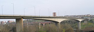
Scotswood Bridge is one of the main bridges crossing the River Tyne in North East England. It links the west end of Newcastle upon Tyne on the north bank of the river with the MetroCentre and Blaydon in Gateshead on the south bank. It is situated 5.2 km (3.2 mi) upstream of the better-known city centre bridges.

Tyne and Wear is a metropolitan area covering the cities of Newcastle upon Tyne and Sunderland, as well as North and South Tyneside, Gateshead and Washington.

The Tyne Valley Line is a 58-mile (93 km) route, linking Newcastle upon Tyne with Hexham and Carlisle, England. The line follows the course of the River Tyne through Tyne and Wear and Northumberland. Five stations and two viaducts on the route are listed structures.
Elswick railway station was a railway station in the Elswick area of Newcastle upon Tyne, England. It was located on the former route of the Newcastle and Carlisle Railway from Newcastle upon Tyne to Carlisle. The station opened in 1889 and closed in 1967.
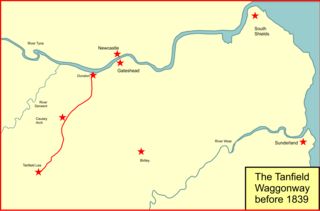
The Brandling Junction Railway was an early railway in County Durham, England. It took over the Tanfield Waggonway of 1725 that was built to bring coal from Tanfield to staiths on the River Tyne at Dunston. The Brandling Junction Railway itself opened in stages from 1839, running from Gateshead to Wearmouth and South Shields. Wearmouth was regarded at the time as the "Sunderland" terminal.

The Newcastle & Carlisle Railway (N&CR) was an English railway company formed in 1825 that built a line from Newcastle upon Tyne on Britain's east coast, to Carlisle, on the west coast. The railway began operating mineral trains in 1834 between Blaydon and Hexham, and passengers were carried for the first time the following year. The rest of the line opened in stages, completing a through route between Carlisle and Gateshead, south of the River Tyne in 1837. The directors repeatedly changed their intentions for the route at the eastern end of the line, but finally a line was opened from Scotswood to a Newcastle terminal in 1839. That line was extended twice, reaching the new Newcastle Central Station in 1851.
The A1 road around Gateshead and Newcastle upon Tyne after arriving from the south as the A1(M) from its origin in London, currently runs from the A1(M) terminus at Birtley. It then swings to the west of both Gateshead and Newcastle via Coal House, Lobley Hill, Metrocentre, Swalwell, Blaydon Bridge, West Denton, Fawdon and Wideopen to Seaton Burn interchange before continuing north towards Edinburgh.

National Cycle Network (NCN) Route 141 is a Sustrans Regional Route. It is 11.2 km (7.0 mi) long. It provides a connection between Route 14 and Route 72 along the south bank of the River Tyne through Gateshead. The full length of the route is part of the Keelmans Way. It is fully signed and open after the section between Wylam and Ryton Golf Course recently reopened after repairs following a landslip.
The ceremonial county of Tyne and Wear has returned 12 MPs to the UK Parliament since 2010. It was created under the Local Government Act 1972, which came into effect on 1 April 1974, comprising the urban areas around the mouths of the Rivers Tyne and Wear, previously parts of the historic counties of Northumberland and Durham.

