Blenheim, Leeds

Last updated

Blenheim
Blenheim Square - Blackman Lane - geograph.org.uk - 411544.jpg
Blenheim Square
Leeds UK location map.svg
Red pog.svg
Blenheim
West Yorkshire UK location map.svg
Red pog.svg
Blenheim
Location within West Yorkshire
Metropolitan borough
Metropolitan county
Region
Country England
Sovereign state United Kingdom
Post town LEEDS
Postcode district LS2
Dialling code 0113
Police West Yorkshire
Fire West Yorkshire
Ambulance Yorkshire
UK Parliament
List of places
UK
England
Yorkshire
53°48′30″N1°32′53″W / 53.8083°N 1.5480°W / 53.8083; -1.5480

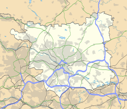
Blenheim is a small area of inner-city Leeds, West Yorkshire, England. It is situated north of the city centre between Little London, Lovell Park and Woodhouse and is generally made of early 20th century terraced housing. Blenheim falls within the Hyde Park and Woodhouse ward of Leeds City Council.

The Georgian/Victorian Blenheim Square is a Conservation Area. [1]

Related Research Articles

<span class="mw-page-title-main">Hyde Park, Leeds</span> Human settlement in England

Hyde Park is an inner-city residential area of north-west Leeds, West Yorkshire, England, situated between the University of Leeds and Headingley. It sits in the Headingley and Hyde Park ward of Leeds City Council.

<span class="mw-page-title-main">Lovell Park</span> Area of Leeds in West Yorkshire, England

Lovell Park is an inner-city area of Leeds, West Yorkshire, England. The area falls within the Hyde Park and Woodhouse ward of the Leeds Metropolitan Council.

<span class="mw-page-title-main">Meanwood</span> Suburb of Leeds in West Yorkshire, England

Meanwood is a suburb and former village in north-west Leeds, West Yorkshire, England.

<span class="mw-page-title-main">Woodhouse, Leeds</span>

Woodhouse is a largely residential area just north of the city centre of Leeds and close to the University of Leeds. The area considered as Woodhouse is partly in the Little London and Woodhouse ward and partly in the Headingley & Hyde Park ward of City of Leeds metropolitan district.

<span class="mw-page-title-main">Rawdon, West Yorkshire</span> Village and civil parish in West Yorkshire, England

Rawdon is a village and civil parish in the metropolitan borough of the City of Leeds, West Yorkshire, England. It sits on the River Aire and on the A65 south of Yeadon.

<span class="mw-page-title-main">Leeds Central (UK Parliament constituency)</span> Parliamentary constituency in the United Kingdom, 1983–2024

Leeds Central was a constituency represented in the House of Commons of the UK Parliament. The constituency first existed from 1885 until it was abolished in 1955. It was recreated in 1983.

<span class="mw-page-title-main">Leeds city centre</span> Central business district of Leeds, West Yorkshire, England

Leeds city centre is the central business district of Leeds, West Yorkshire, England. It is roughly bounded by the Inner Ring Road to the north and the River Aire to the south and can be divided into several quarters.

<span class="mw-page-title-main">A660 road</span> Road in West Yorkshire, England

The A660 is a major road in the Leeds and Bradford districts of West Yorkshire, England that runs from Leeds city centre to Burley-in-Wharfedale where it meets the A65. The A660 is approximately 10 miles (16 km) long, and crosses the watershed from Airedale to lower Wharfedale. For most of its length the road is in the metropolitan district of the City of Leeds; the last 0.4 miles (0.6 km) is in City of Bradford district.

<span class="mw-page-title-main">Apperley Bridge</span> Village in West Yorkshire, England

Apperley Bridge is a village in the metropolitan borough of the City of Bradford, in West Yorkshire, England in the Idle and Thackley Ward. Apperley Bridge is north-east of Bradford on the boundary with the City of Leeds bounded in the east by Carr Beck and to the south by Greengates. The village straddles the Leeds and Liverpool Canal and the River Aire. It takes its name from the old bridge over the river on Apperley Lane.

<span class="mw-page-title-main">Woodhouse Moor</span>

Woodhouse Moor is an open space approximately one mile (1.6 km) from Leeds city centre, West Yorkshire, England. Today it consists of 3 parts: a formal park, Woodhouse Moor, of around 26 hectares in area on the west of Woodhouse Lane, and two other open areas on the east of it. These are known as the Monument and Cinder Moors which are used for events such as circuses and sporting matches, and sometimes car parking. Woodhouse Moor is north-west of Leeds city centre and is bounded by Woodhouse, the University of Leeds, Burley, Hyde Park, and Headingley.

<span class="mw-page-title-main">Meanwood Valley Trail</span> Walking route in Leeds, England

The Meanwood Valley Trail is a waymarked footpath and the title of an annual (March/April) footrace that takes place on parts of the trail in Leeds, West Yorkshire, England. It runs for a distance of 7 miles (11 km) from the statue of Henry Rowland Marsden, 1878, on Woodhouse Moor, close to the University of Leeds, through Headingley, Meanwood and Adel to Breary Marsh, Golden Acre Park, where it meets the Leeds Country Way. For most of its route it is the official Leeds link to the Dales Way. Along the way are signs giving information about the local wildlife. The first stages of the White Rose Way follow part of the trail also before continuing to Scarborough.

<span class="mw-page-title-main">Architecture of Leeds</span> Buildings of Leeds, West Yorkshire, England

The architecture of Leeds, a city and metropolitan borough in West Yorkshire, England, encompasses a wide range of architectural styles and notable buildings. As with most northern industrial centres, much of Leeds' prominent architecture is of the Victorian era. However, the City of Leeds also contains buildings from as early as the Middle Ages such as Kirkstall Abbey, one of Britain's best preserved ruined Cistercian monasteries, as well as examples of 20th century industrial architecture, particularly in the districts of Hunslet and Holbeck.

<span class="mw-page-title-main">Woodhouse Ridge</span>

Woodhouse Ridge is a strip of woodland on the South West hillside of the Meanwood valley in urban area of Leeds, West Yorkshire, England. Locally known as 'The Ridge', the area is notable as a significant area of mature woodland in an otherwise highly developed urban area. The woods are centred at grid reference 53.820061, -1.560144 and are enclosed by Meanwood Road to the east and by Headingley to the north and Woodhouse, Leeds to the South.

The 1952 Leeds municipal elections were held on Thursday 8 May 1952, with one third of the council to be elected.

The 1954 Leeds municipal elections were held on Thursday 14 May 1954, with one third of the council up for election.

The 1945 Leeds municipal elections were held on Thursday 1 November 1945. Although a third of the council would ordinarily be up for election, the suspension of elections during World War II meant the council had last held elections in 1938, and with the amount of vacancies and co-options throughout near to two-thirds of the council needed electing.

<span class="mw-page-title-main">Little London and Woodhouse (ward)</span> Electoral ward in Leeds, England

Little London and Woodhouse is an electoral ward of Leeds City Council in Leeds, West Yorkshire, covering the urban areas of Little London and Woodhouse to the north of the city centre. It was created in advance of the 2018 council election.

<span class="mw-page-title-main">St Augustine's Church, Wrangthorn</span> Church in Leeds, West Yorkshire, England

St Augustine's Church, Wrangthorn, usually referred to as simply Wrangthorn, is the church of the parish of Woodhouse and Wrangthorn, Leeds, West Yorkshire, England. It is near Hyde Park Corner at the top of Woodhouse Moor. It shares a benefice and clergy with St George's Church in the city centre, although the parishes remain separate. It was paid for by the Leeds Church Extension Society in 1866 and completed in 1871. The church, which is a Grade II listed building is on a ridge of land between Meanwood Beck and the Aire Valley, on the north-west side of the city. Its architect, James Barlow Fraser (1835–1922), took advantage of this prominent location by including a three-stage pointed steeple; its blackened stone is a local landmark. The church is built in local gritstone ashlar in the Gothic Revival style and is adjoined by the smaller church hall of 1934.

Hyde Park and Woodhouse are areas in the metropolitan borough of the City of Leeds, West Yorkshire, England. The areas contain 149 listed buildings that are recorded in the National Heritage List for England. Of these, five are listed at Grade II*, the middle of the three grades, and the others are at Grade II, the lowest grade. The areas are largely residential, and also contain the University of Leeds. Many of the university buildings are listed, some of which are newly built, and others have been converted from pre-existing buildings. Most of the other listed buildings are houses and associated structures, and the rest include churches and memorials in churchyards, a public house, statues and other memorials, buildings in the former Woodhouse Cemetery, schools and associated structures, a cross, and public buildings.

References

  1. "Blenheim Square Conservation Area" (PDF). Leeds City Council. Archived from the original (PDF) on 10 June 2011. Retrieved 11 May 2009.