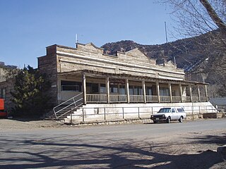
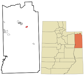
Kenilworth is a census-designated place in northern Carbon County, Utah, United States.

Menoken is an unincorporated community and a census-designated place (CDP) in southwestern Burleigh County, North Dakota, United States. It was designated as part of the U.S. Census Bureau's Participant Statistical Areas Program on June 10, 2010. It was not counted separately during the 2000 Census, but was included in the 2010 Census, where a population of 70 was reported.
Grouse Creek is an unincorporated community in the nearly unpopulated northwestern region of Box Elder County, Utah, United States, near the Idaho and Nevada borders. The community lies along unpaved roads north of State Route 30 in the Grouse Creek Mountains. Its elevation is 5,331 feet (1,625 m). It has a post office with the ZIP code 84313.
Altonah is an unincorporated community in central Duchesne County, Utah, United States.
Fruitland is an unincorporated community in western Duchesne County, Utah, United States, on the Uintah and Ouray Indian Reservation.
Hanna is an unincorporated community in western Duchesne County, Utah, United States, on the Uintah and Ouray Indian Reservation.
Jensen is a census-designated place in eastern Uintah County, Utah, United States. The population was 372 at the 2020 census. It lies along the Green River and U.S. Route 40, southeast of the city of Vernal, the county seat of Uintah County, and about 17 miles west of the Colorado border. Although Jensen is unincorporated, it has a post office, with the ZIP code of 84035.

Mountain Home is an unincorporated community in central Duchesne County, Utah, United States, adjacent to the Uintah and Ouray Indian Reservation.

Peoa is an unincorporated census-designated place in southwestern Summit County, Utah, United States, between Jordanelle and Rockport State Parks. It lies along State Route 32, south of the city of Coalville, the county seat of Summit County. Its elevation is 6,191 feet (1,887 m). The population was 253 at the 2010 census. Peoa is unincorporated with the ZIP code of 84061.
Tridell is an unincorporated community in the Uinta Basin in western Uintah County, Utah, United States.

Central is a census-designated place in north-central Washington County, Utah, United States. The population was 613 at the 2010 census. Central lies along State Route 18, on the edge of the Dixie National Forest, north of the city of St. George.
Greenwich is an unincorporated community in northeastern Piute County, Utah, United States, just east of the Fishlake National Forest. It lies along State Route 62 northeast of the town of Junction, the county seat of Piute County. Its elevation is 6,854 feet (2,089 m). Although Greenwich is unincorporated, it has a post office, with the ZIP code of 84732. Greenwich is said to be an anglicized form of a Native American name.

Modena is an unincorporated community in far western Iron County, near the Nevada border in southwestern Utah, United States.

Newcastle is an unincorporated community and census-designated place (CDP) in southwestern Iron County, Utah, United States. It lies along State Route 56, 30 miles (48 km) west of Cedar City. Its elevation is 5,312 feet (1,619 m) above sea level. Newcastle has a post office with the ZIP code of 84756. The population was 247 at the 2010 census. Newcastle was founded in 1910 by citizens of the more isolated Pinto.

Teasdale is a census-designated place in western Wayne County, Utah, United States, between the Dixie and Fishlake National Forests and near Capitol Reef National Park. The population was 191 at the 2010 census. Teasdale lies along local roads south of State Route 24, southeast of the town of Loa, the county seat of Wayne County. Teasdale has a post office with the ZIP code 84773.

Veyo is a census-designated place in western Washington County, Utah, United States, on the edge of the Dixie National Forest. The population was 483 at the 2010 census. The town lies along State Route 18 north of the city of St. George.

Keystone is an unincorporated community and census-designated place in central Keith County, Nebraska, United States. As of the 2010 census its population was 59.

Beulah is a census-designated place (CDP) in eastern Crook County, Wyoming, United States, along Sand Creek, a tributary of the Belle Fourche River. According to local residents, the population is 33. When the 2010 census reported the population as 73, the highway sign at the town entrance was changed. In 2012, Beulah residents succeeded in appealing to the Wyoming Governor to remove the new sign and replace it with one that proclaimed the population to be 33.
Farnsworth is a census designated place in western Ochiltree County, Texas, United States. It lies at the intersection of State Highway 15 with FM376, southwest of the city of Perryton, the county seat of Ochiltree County. Its elevation is 2,995 feet (913 m). Although Farnsworth is unincorporated, it has a post office, with the ZIP code of 79033; the ZCTA for ZIP code 79033 had a population of 106 at the 2000 census.

Animas is an unincorporated community and census-designated place (CDP) in west-central Hidalgo County, New Mexico, United States, in the southwestern corner of the state. As of the 2010 census it had a population of 237.

