
Duchesne County is a county in the northeast part of the U.S. state of Utah. As of the 2010 United States Census, the population was 18,607. Its county seat is Duchesne, and the largest city is Roosevelt.

Altamont is a town in Duchesne County, Utah, United States. The population was 225 at the 2010 census, an increase over the 2000 figure of 178.

Duchesne is a city in and the county seat of Duchesne County, Utah, United States. The population was 1,588 at the 2020 census.

Roosevelt is a city in Duchesne County, Utah, United States. The population was 6,046 at the 2010 census, with an estimated population of 7,070 in 2018.

Gould City is an unincorporated community in Mackinac County in the U.S. state of Michigan. The community is located within Newton Township. As an unincorporated community, Gould City has no legal autonomy of its own but does have its own post office with the 49838 ZIP Code.
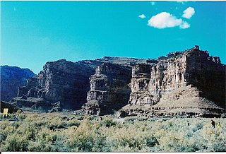
Ninemile Canyon is a canyon, approximately 40 miles (64 km) long, located in Carbon and Duchesne counties in eastern Utah, United States. Promoted as "the world's longest art gallery", the canyon is known for its extensive rock art, most of it created by the Fremont culture and the Ute people. The rock art, shelters, and granaries left behind by the Fremont make Ninemile Canyon a destination for archaeologists and tourists alike.

The Dinosaur Diamond is a 486-mile (782 km) scenic and historic byway loop through the dinosaur fossil laden Uinta Basin of the U.S. states of Utah and Colorado. The byway comprises the following two National Scenic Byways:
Hanna is an unincorporated community in western Duchesne County, Utah, United States, on the Uintah and Ouray Indian Reservation.

State Route 121 (SR-121) is a state highway that is an alternative to US-40 and US-191. It serves the communities of Vernal, Lapoint, Neola, Cedarview, and Roosevelt. From Vernal to Neola, it is signed as an east–west route. Then, from Neola to State Street in Roosevelt, it is signed as a north–south route. The route is once-more signed east–west from Roosevelt to US-40/US-191.
Strawberry is an unincorporated community in western Duchesne County, Utah, United States. Most of the inhabitants live along the Strawberry River between the Strawberry River pinnacles and Starvation Reservoir west of the city of Duchesne, the county seat of Duchesne County.

Barlow, Pennsylvania is a populated place between the Gettysburg Battlefield and the Mason–Dixon line at the intersection of Rock Creek and Pennsylvania Route 134. North of the creek on the road summit is the principal facility of the rural community: the 1939 community hall at the Barlow Volunteer Fire Company fire station. The hall is a Cumberland Township polling place and was used by Mamie & Dwight D. Eisenhower after purchasing their nearby farm. Horner's Mill was the site of an 1861 Union Civil War encampment, and the covered bridge was used by the II Corps and General George G. Meade en route to the 1863 Battle of Gettysburg.
Secor, previously known as Xenia and Delanti, is a ghost town in Hardin County, Iowa, United States. The community was 3.5 miles (5.6 km) south-southeast of Eldora. In its early years, the community was the site of one of the few bridges across the Iowa River in Hardin County. By the mid-20th century, however, the community had lost its school, mill, post office, and businesses, and Secor was considered a ghost town.
Cedarview or Cedar View may refer to:
Diamond is a ghost town in eastern Juab County, Utah, United States. The Diamond Cemetery is listed on the National Register of Historic Places.
Ioka is an unincorporated community in eastern Duchesne County, Utah, United States.

Upalco is an unincorporated community in eastern Duchesne County, Utah, United States.
Utahn is an unincorporated community and near-ghost town in Duchesne County, Utah, United States.
Duchesne County School District (DCSD) is a school district headquartered in Roosevelt, Utah. It serves all of Duchesne County.
Castle Rock, also known as "Frenchies" is a ghost town in Summit County, Utah, United States. The location is currently the site of an automotive junk yard. Some buildings, such as the town's gas station, still stand.


