
Agusan del Norte, officially the Province of Agusan del Norte, is a province in the Caraga region of the Philippines. Its de jure capital is the city of Cabadbaran with several government offices located in the highly-urbanized city of Butuan, which is the largest city and its de facto capital as well as the regional center of Caraga Region. It is bordered on the northwest by Butuan Bay; northeast by Surigao del Norte; mid-east by Surigao del Sur; southeast by Agusan del Sur, and southwest by Misamis Oriental.

Agusan del Sur, officially the Province of Agusan del Sur, is a province in Caraga region, Mindanao, Philippines. Its capital is the municipality of Prosperidad. It is bordered on the northwest by Agusan del Norte and Misamis Oriental; east by Surigao del Sur; southeast by Davao Oriental; mid-south by Davao de Oro; southwest by Davao del Norte and, mid-west by Bukidnon. It is the fourth largest province in the country in terms of area, with the size of 3,856 sq miles.

Caraga, officially the Caraga Administrative Region and designated as Region XIII, is an administrative region in the Philippines occupying the northeastern section of Mindanao. The region was created through Republic Act No. 7901 on February 23, 1995. The region comprises five provinces: Agusan del Norte, Agusan del Sur, Dinagat Islands, Surigao del Norte, and Surigao del Sur; six cities: Bayugan, Bislig, Butuan, Cabadbaran, Surigao and Tandag; 67 municipalities and 1,311 barangays. Butuan, the most urbanized city in Caraga, serves as the regional administrative center.

Tandag, officially the City of Tandag, is a 5th class component city and capital of the province of Surigao del Sur, Philippines. According to the 2020 census, it has a population of 62,669 people.
Sibagat, officially the Municipality of Sibagat, is a 1st class municipality in the province of Agusan del Sur, Philippines. According to the 2020 census, it has a population of 33,957 people.
Butuan, officially the City of Butuan, is a 1st class highly urbanized city and the regional center of Caraga, Philippines. It is the de facto capital of the province of Agusan del Norte where it is geographically situated but has an administratively independent government. According to the 2020 census, it has a population of 372,910 people making it the most populous city in Caraga Region.

Las Nieves,, officially the Municipality of Las Nieves, is a 2nd class municipality in the province of Agusan del Norte, Philippines. According to the 2020 census, it has a population of 30,240 people.

Remedios T. Romualdez, officially the Municipality of Remedios T. Romualdez, is a 5th class municipality in the province of Agusan del Norte, Philippines. According to the 2020 census, it has a population of 17,155 people, making it the least populated town in the province.
Bayugan, officially the City of Bayugan, is a 5th class component city in the province of Agusan del Sur, Philippines. According to the 2020 census, it has a population of 109,499 people..

Esperanza, officially the Municipality of Esperanza, is a 1st class municipality in the province of Agusan del Sur, Philippines. According to the 2020 census, it has a population of 59,353 people.

San Francisco, officially the Municipality of San Francisco, is a 1st class municipality in the province of Agusan del Sur, Philippines. According to the 2020 census, it has a population of 80,760 people.
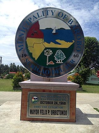
Barobo, officially the Municipality of Barobo is a 3rd class municipality in the province of Surigao del Sur, Philippines. According to the 2020 census, it has a population of 53,146 people.
The Wawa River is a river located in Caraga, in northeastern Mindanao, in the southern Philippine island. Its headwaters traverse the municipality of Sibagat, Bayugan, and Esperanza. The Wawa River is a tributary of the larger Agusan River.
Camponay Falls is located in Camponay Village in barangay Tabontabon, Sibagat, Agusan del Sur in the southern Philippine island of Mindanao. A cave can be found in the middle of the waterfalls within a secondary forests which is a potential for local outdoor and recreation site. Listed as one of the attractive landmarks in the Province of Agusan del Sur.

The Sibagat River is a stream located in Sibagat, Agusan del Sur, Caraga Region, Philippines. It is a tributary of the larger Wawa River with headwaters located in the northeastern mountain boundaries of Sibagat and Butuan.

The Butuan–Cagayan de Oro–Iligan Road, or Butuan–Cagayan de Oro–Iligan–Tukuran Road, is a 416-kilometer (258 mi), two-to-six lane major thoroughfare, connecting the provinces of Agusan del Norte, Misamis Oriental, Lanao del Norte, and Zamboanga del Sur.
Managong Falls is known to be the biggest and tallest waterfalls in the province of Agusan del Sur. Located in barangay Padiay in the municipality of Sibagat, Agusan del Sur, Caraga Region, in the southern Philippine island of Mindanao, is one of the tourist attractions and ecotourism sites of Sibagat.
The Tambagoko River is a stream located in Sibagat, Agusan del Sur, Caraga Region, Philippines. It is a tributary of the Sibagat River with headwaters located in the hinterlands of Barangays Perez and Sta. Cruz.
The Andanan River is a stream located in Sibagat, Agusan del Sur and Bayugan, Caraga Region, Philippines. It is a tributary of the larger Wawa River.
The Tago River is a stream located in Sibagat, Agusan del Sur, and the municipalities of San Miguel and Tago, Surigao del Sur, Caraga Region, in northeastern Mindanao, in southern Philippines.

