Bolton, Kansas

Last updated

Bolton, Kansas
Map of Montgomery Co, Ks, USA.png
USA Kansas location map.svg
Red pog.svg
Bolton
Usa edcp location map.svg
Red pog.svg
Bolton
Coordinates: 37°09′24″N95°48′20″W / 37.15667°N 95.80556°W / 37.15667; -95.80556 [1]
Country United States
State Kansas
County Montgomery
Founded1886
Platted 1886
Elevation
[1]
820 ft (250 m)
Time zone UTC-6 (CST)
  Summer (DST) UTC-5 (CDT)
Area code 620
FIPS code 20-07900
GNIS ID 484441 [1]

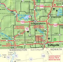
Bolton is an unincorporated community in Montgomery County, Kansas, United States. [1]

Contents

History

Bolton was laid out in 1886 when the railroad was extended to that point. [2]

Related Research Articles

Montgomery County may refer to:

<span class="mw-page-title-main">Montgomery County, Kansas</span> County in Kansas, United States

Montgomery County is a county located in Southeast Kansas. Its county seat is Independence, and its most populous city is Coffeyville. As of the 2020 census, the county population was 31,486. The county was named after Richard Montgomery, a major general during the American Revolutionary War.

<span class="mw-page-title-main">Wilson County, Kansas</span> County in Kansas, United States

Wilson County is a county located in Southeast Kansas. Its county seat is Fredonia. As of the 2020 census, the county population was 8,624. The county was named after Hiero Wilson, a colonel in the American Civil War.

<span class="mw-page-title-main">Metropolitan Borough of Bolton</span> Borough of Greater Manchester, England

The Metropolitan Borough of Bolton is a metropolitan borough in Greater Manchester, England, named after its largest town, Bolton, but covering a larger area which includes Blackrod, Farnworth, Horwich, Kearsley, Westhoughton, and part of the West Pennine Moors. It had a population of 276,800 at the 2011 census, making it the fourth-most populous district in Greater Manchester.

<span class="mw-page-title-main">Kansas's 2nd congressional district</span> U.S. House district for Kansas

Kansas' 2nd congressional district is a congressional district in the U.S. state of Kansas that covers most of the eastern part of the state, except for the core of the Kansas City Metropolitan Area. The district encompasses less than a quarter of the state. The state capital of Topeka, the cities of Emporia, Junction City and Leavenworth and most of Kansas City are located within this district. The district is currently represented by Republican Jake LaTurner.

<span class="mw-page-title-main">Jeff Montgomery (baseball)</span> American baseball player

Jeffrey Thomas Montgomery is an American former Major League Baseball relief pitcher. During a 13-year baseball career, he pitched from 1987 to 1999, primarily for the Kansas City Royals.

<span class="mw-page-title-main">National Register of Historic Places listings in Kansas</span>

There are over 1,400 buildings, sites, districts, and objects in Kansas listed on the National Register of Historic Places in Kansas. NRHP listings appear in 101 of the state's 105 counties.

<span class="mw-page-title-main">Southeast Kansas</span> Region of Kansas, US

Southeast Kansas is a region of the U.S. state of Kansas. It can be roughly defined by Woodson County in the northwest, Bourbon County in the northeast, Cherokee County in the southeast, and Montgomery County in the southwest. Geographically it is dominated by a broad rolling landscape located between the Flint Hills to the west and includes the Ozarks to the southeast. Some notable towns there include Pittsburg, Parsons, Coffeyville, Independence, Chanute, Fort Scott, and Iola.

<span class="mw-page-title-main">James Montgomery (colonel)</span>

James Montgomery was a Jayhawker during the Bleeding Kansas era and a controversial Union colonel during the American Civil War. Montgomery was a staunch supporter of abolitionist principles and individual liberty. He liberated slaves during his raids. He also burned and looted pro-slavery populations.

The four-state area or quad-state area, is the area where the states of Arkansas, Kansas, Missouri, and Oklahoma almost touch: Arkansas and Kansas share no boundary. The Tulsa, Oklahoma; Joplin, Missouri; and Fayetteville–Springdale–Rogers, Arkansas, metropolitan areas are located within the region. Notable cities and towns in the area are Tulsa and Miami, Oklahoma; Pittsburg, Kansas; Joplin, Springfield, and Monett, Missouri; and Fayetteville, Springdale, Rogers, and Bentonville, Arkansas.

<span class="mw-page-title-main">Bolton Township, Cowley County, Kansas</span> Township in Kansas, United States

Bolton Township is a township in Cowley County, Kansas, USA. As of the 2000 census, its population was 1,754.

<span class="mw-page-title-main">Sycamore, Kansas</span> Unincorporated community in Montgomery County, Kansas

Sycamore is an unincorporated community in northern Montgomery County, Kansas, United States. As of the 2020 census, the population of the community and nearby areas was 70. It is located along U.S. Route 75 north of the city of Independence.

Montgomery County Courthouse may refer to:

<span class="mw-page-title-main">National Register of Historic Places listings in Montgomery County, Kansas</span>

This is a list of the National Register of Historic Places listings in Montgomery County, Kansas.

<span class="mw-page-title-main">Jefferson, Kansas</span> Unincorporated community in Montgomery County, Kansas

Jefferson is an unincorporated in Montgomery County, Kansas, United States.

<span class="mw-page-title-main">1976 United States presidential election in Maryland</span> U.S. presidential election in Maryland

The 1976 United States presidential election in Maryland was held on November 2, 1976 as part of the 1976 United States presidential election. Incumbent Republican President Gerald Ford of Michigan and his running mate Senator Bob Dole of Kansas lost to the Democratic challengers, Governor Jimmy Carter of Georgia and Senator Walter Mondale of Minnesota. Carter and Mondale won Maryland with 53.04% of the vote compared to Ford and Dole’s 46.96% – a comfortable margin of 6.08%.

<span class="mw-page-title-main">1964 United States presidential election in Kansas</span> Election in Kansas

The 1964 United States presidential election in Kansas took place on November 3, 1964, as part of the 1964 United States presidential election. Voters chose seven representatives, or electors, to the Electoral College, who voted for president and vice president.

<span class="mw-page-title-main">1982 Kansas gubernatorial election</span> Election for the governorship of the U.S. state of Kansas

The 1982 Kansas gubernatorial election was held on November 2, 1982. Incumbent Democrat John W. Carlin defeated Republican nominee Sam Hardage with 53.2% of the vote.

<span class="mw-page-title-main">Nick Bolton</span> American football player (born 2000)

Nicholas Bolton is an American football linebacker for the Kansas City Chiefs of the National Football League (NFL). He played college football at Missouri, and was drafted by the Chiefs in the second round of the 2021 NFL Draft.

References

  1. 1 2 3 4 U.S. Geological Survey Geographic Names Information System: Bolton, Kansas
  2. Duncan, L. Wallace (1903). History of Montgomery County, Kansas. Press of Iola Register. pp.  81.

Further reading