
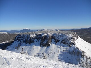
Mount Bachelor, formerly named Bachelor Butte, is a dormant stratovolcano atop a shield volcano in the Cascade Volcanic Arc and the Cascade Range of central Oregon, United States. Named Mount Bachelor because it stands apart from the nearby Three Sisters, it lies in the eastern segment of the central portion of the High Cascades, the eastern segment of the Cascade Range. The volcano lies at the northern end of the 15-mile (24 km) long Mount Bachelor Volcanic Chain, which underwent four major eruptive episodes during the Pleistocene and the Holocene. The United States Geological Survey considers Mount Bachelor a moderate threat, but Bachelor poses little threat of becoming an active volcano in the near future. It remains unclear whether the volcano is extinct or just inactive.

Mount Jefferson is a stratovolcano in the Cascade Volcanic Arc, part of the Cascade Range in the U.S. state of Oregon. The second highest mountain in Oregon, it is situated within Linn County, Jefferson County, and Marion County and forms part of the Mount Jefferson Wilderness. Due to the ruggedness of its surroundings, the mountain is one of the hardest volcanoes to reach in the Cascades. It is also a popular tourist destination despite its remoteness, with recreational activities including hiking, backpacking, mountaineering, and photography. Vegetation at Mount Jefferson is dominated by Douglas fir, silver fir, mountain hemlock, ponderosa pine, lodgepole pine, and several cedar species. Carnivores, insectivores, bats, rodents, deer, birds, and various other species inhabit the area.

Mount McLoughlin is a dormant steep-sided stratovolcano, or composite volcano, in the Cascade Range of southern Oregon and within the United States Sky Lakes Wilderness. It is one of the volcanic peaks in the Cascade Volcanic Arc, within the High Cascades sector. A prominent landmark for the Rogue River Valley, the mountain is north of Mount Shasta, and south-southwest of Crater Lake. It was named around 1838 after John McLoughlin, a Chief Factor for the Hudson's Bay Company. Mount McLouglin's prominence has made it a landmark to Native American populations for thousands of years.
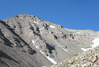
Castle Peak is the ninth highest summit of the Rocky Mountains of North America and the U.S. state of Colorado. The prominent 14,272-foot (4350.20 m) fourteener is the highest summit of the Elk Mountains and the Maroon Bells-Snowmass Wilderness. The peak is located 11.6 miles (18.7 km) northeast by north of the Town of Crested Butte, Colorado, United States, on the drainage divide separating Gunnison National Forest and Gunnison County from White River National Forest and Pitkin County. The summit of Castle Peak is the highest point of both counties.
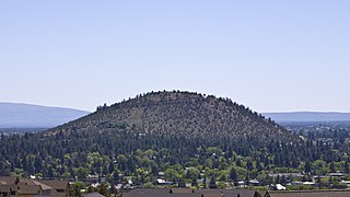
Pilot Butte is a lava dome that was created from an extinct volcano located in Bend, Oregon. It is a cinder cone butte which rises nearly 500 feet (150 m) above the surrounding plains. Bend is one of six cities in the United States to have a volcano within its boundaries. The other examples are Mount Tabor in Portland, Oregon, Jackson Volcano in Jackson, Mississippi, Diamond Head in Honolulu, Glassford Hill in Prescott Valley and Pilot Knob in Austin, Texas.

The Boring Lava Field is a Plio-Pleistocene volcanic field of cinder cones, small shield volcanoes, and lava flows in the northern Willamette Valley of the U.S. state of Oregon and adjacent southwest Washington. The volcanic field is named for the town of Boring, Oregon, located 12 miles (20 km) southeast of downtown Portland and on the edge of the densest cluster of volcanic vents. The zone became volcanically active about 2.7 million years ago, with long periods of eruptive activity interspersed with quiescence. Its last eruptions took place about 57,000 years ago at the Beacon Rock cinder cone volcano. The individual volcanic vents of the field are considered extinct, but the field itself is not.

Black Butte is an extinct stratovolcano in the U.S. state of Oregon. Located in Jefferson County, it is part of Deschutes National Forest. Black Butte forms part of the Cascade volcanic arc. The butte lies just south of the Metolius Springs, which merge to form the headwaters of the Metolius River. The Metolius River's basin sustains a wide array of plant life, large and small mammals, and more than 80 bird species.

Powell Butte is an extinct cinder cone butte in Portland, Oregon, United States. It is part of the Boring Lava Field, which includes more than 80 small volcanic edifices and lava flows in the Portland–Vancouver metropolitan area. The region around Powell Butte has a cool climate, and the butte and its surroundings feature meadows, rivers, and mixed forests. Powell Butte hosts the Powell Butte Nature Park, which includes about 612 acres (2.48 km2) of trails for biking, hiking, and horseback riding.

Olallie Butte is a steep-sided shield volcano in the Cascade Range of the northern part of the U.S. state of Oregon. It is the largest volcano and highest point in the 50-mile (80 km) distance between Mount Hood and Mount Jefferson. Located just outside the Olallie Scenic Area, it is surrounded by more than 200 lakes and ponds fed by runoff, precipitation, and underground seepage, which are popular spots for fishing, boating, and swimming. The butte forms a prominent feature in the Mount Jefferson region and is usually covered with snow during the winter and spring seasons.
Hayrick Butte is a tuya, a type of subglacial volcano, in Linn County, Oregon. Located in the Willamette National Forest near Santiam Pass, it lies adjacent to the cinder cone Hoodoo Butte, which has a ski area. Hayrick Butte likely formed when lava erupted underneath an overlying glacier or ice sheet, producing the flat top with near-vertical walls along the ice-contact margin as the lava cooled and hardened. Hayrick Butte has a nearly flat plateau about 0.5 miles (0.80 km) across and steep walls rising about 700 feet (0.21 km) above its surroundings. A cartographer accidentally switched the names for nearby Hoodoo Butte and Hayrick Butte; the word "hoodoo" usually refers to rock piles and pinnacles like those observed at Hayrick Butte.

Pelican Butte is a steep-sided shield volcano in the Cascade Range of southern Oregon. It is located 28 miles (45 km) due south of Crater Lake and 12 miles (19 km) northeast of Mount McLoughlin. Pelican Butte is the most prominent shield volcano in the southern Oregon Cascades and has a large volume at 4.8 cubic miles (20 km3), making it one of the bigger Quaternary volcanoes in the region, approaching the size of some of the range's stratovolcanoes. While still part of the Cascades, Pelican Butte is disconnected from the main axis, forming above faults along the eastern border of the range. Pelican Butte is part of the Quaternary Mount McLoughlin Reach, a volcanic vent zone that runs from the volcano to Aspen Lake, encompassing 33 vents over an area of 357 square miles (925 km2). Ice age glaciers carved a large cirque into the northeast flank of the mountain, but despite this erosion, its original shape is largely preserved. Several proposals have been made over the last few decades for the development of a ski area on this flank, but none have been implemented.
Aspen Butte is a steep-sided shield volcano in the Cascade Range of southern Oregon. It is located 15 miles (24 km) south of Pelican Butte and 15 miles (24 km) southeast of Mount McLoughlin. It rises over 4,000 feet (1,200 m) above the nearby shore of Upper Klamath Lake. Ice Age glaciers carved three large cirques into the north and northeast flanks of the mountain removing most of the original summit area including any evidence of a crater. The summit is now the high point along the curving ridge which bounds the southern edge of the cirques above steep cliffs.
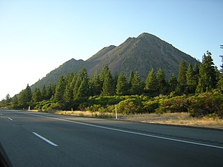
Black Butte is a cluster of overlapping dacite lava domes in a butte, a satellite cone of Mount Shasta. It is located directly adjacent to the northbound lanes of Interstate 5 at milepost 742 between the cities of Mount Shasta and Weed, California. The I-5 freeway crosses a 3,912 ft (1,192 m) pass, Black Butte Summit, at the western base of the lava domes. The lava domes were extruded at the foot of the cone of Shastina following the period of its major eruptions about 9,000–10,000 years ago.

The Crooked River is a tributary, 125 miles (201 km) long, of the Deschutes River in the U.S. state of Oregon. The river begins at the confluence of the South Fork Crooked River and Beaver Creek in southeastern Crook County. Of the two tributaries, the South Fork Crooked River is the larger and is sometimes considered part of the Crooked River proper. A variant name of the South Fork Crooked River is simply "Crooked River". The Deschutes River flows north into the Columbia River.

Little Butte Creek is a 17-mile-long (27 km) tributary of the Rogue River in the U.S. state of Oregon. Its drainage basin consists of approximately 354 square miles (917 km2) of Jackson County and another 19 square miles (49 km2) of Klamath County. Its two forks, the North Fork and the South Fork, both begin high in the Cascade Range near Mount McLoughlin and Brown Mountain. They both flow generally west until they meet near Lake Creek. The main stem continues west, flowing through the communities of Brownsboro, Eagle Point, and White City, before finally emptying into the Rogue River about 3 miles (5 km) southwest of Eagle Point.
Big Butte Creek is a 12-mile-long (19 km) tributary of the Rogue River in the U.S. state of Oregon. It drains approximately 245 square miles (635 km2) of Jackson County. Its two forks, the North Fork and the South Fork, both begin high in the Cascade Range near Mount McLoughlin. Flowing predominantly west, they meet near the city of Butte Falls. The main stem flows generally northwest until it empties into the Rogue Falls was incorporated in 1911, and remains the only incorporated town within the watershed's boundaries.
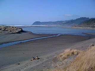
The Pistol River is a coastal stream that meanders for 21 miles (34 km) through the Southern Oregon Coast Range to the Pacific Ocean near the unincorporated community of Pistol River in the U.S. state of Oregon. Flowing generally southwest from its origin near Sugarloaf Mountain in the Siskiyou National Forest, the river enters the sea at Pistol River State Scenic Viewpoint, 10 miles (16 km) south of Gold Beach. The river received its name after pioneer James Mace lost his pistol in it in 1853.

Poston Butte, formerly called Primrose Hill, is a hill located along Hunt Highway in Florence, Pinal County, Arizona, United States, near the eastern end of the Santan Mountains. Geologically, it is characterized by basalts overlying altered granite.

Hager Mountain is a volcanic peak in Oregon in the northwest corner of the Basin and Range Province in the United States. The mountain is located south of the small unincorporated community of Silver Lake in south-central Oregon, and it is in the Fremont–Winema National Forest. On the summit, there is a fire lookout operated during the summer and fall by the United States Forest Service. There are several hiking trails that lead to the lookout station.
